File:New York state geographic map-en.svg

Original file (SVG file, nominally 2,811 × 2,000 pixels, file size: 18.34 MB)
Captions
Captions
Summary[edit]
| Description |
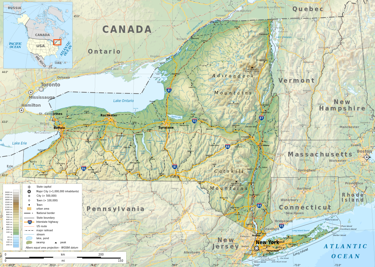
English: Geographic map of New York state in English. Geographic limits of the map:
|
| Date | |
| Source |
Own work
|
| Creator | |
| Permission (Reusing this file) |
Any use of this map is subject of the license(s) stated below with the condition that you credit (Wikimedia Commons user: Ikonact) as the author . A message with a reply address would also be greatly appreciated. |
| Georeferencing | If inappropriate please set warp_status = skip to hide. |
|

|
This SVG file contains embedded text that can be translated into your language, using any capable SVG editor, text editor or the SVG Translate tool. For more information see: About translating SVG files. |
Licensing[edit]
| This work contains information from OpenStreetMap, which is made available under the Open Database License (ODbL).
The ODbL does not require any particular license for maps produced from ODbL data. Prior to 1 August 2020, map tiles produced by the OpenStreetMap Foundation were licensed under the CC-BY-SA-2.0 license. Maps produced by other people may be subject to other licences. |
- You are free:
- to share – to copy, distribute and transmit the work
- to remix – to adapt the work
- Under the following conditions:
- attribution – You must give appropriate credit, provide a link to the license, and indicate if changes were made. You may do so in any reasonable manner, but not in any way that suggests the licensor endorses you or your use.
- share alike – If you remix, transform, or build upon the material, you must distribute your contributions under the same or compatible license as the original.
File history
Click on a date/time to view the file as it appeared at that time.
| Date/Time | Thumbnail | Dimensions | User | Comment | |
|---|---|---|---|---|---|
| current | 12:15, 2 November 2023 | | 2,811 × 2,000 (18.34 MB) | Ikonact (talk | contribs) | corrected some typos in names // Editing SVG source code using c:User:Rillke/SVGedit.js |
| 10:22, 14 October 2019 |  | 2,811 × 2,000 (18.41 MB) | Ikonact (talk | contribs) | better dealing with fall back font | |
| 21:19, 12 October 2019 |  | 2,811 × 2,000 (20.53 MB) | Ikonact (talk | contribs) | + fall back font, more towns and islands, provinces | |
| 23:33, 11 October 2019 |  | 2,811 × 2,000 (20.47 MB) | Ikonact (talk | contribs) | error corrected | |
| 23:23, 11 October 2019 |  | 2,811 × 2,000 (20.47 MB) | Ikonact (talk | contribs) | river and lake names added | |
| 21:58, 8 October 2019 |  | 2,811 × 2,000 (20.33 MB) | Ikonact (talk | contribs) | some improvements, roads and cities in Canada | |
| 07:40, 22 September 2019 |  | 2,811 × 2,000 (14.39 MB) | Ikonact (talk | contribs) | small corrections | |
| 20:49, 21 September 2019 |  | 2,811 × 2,000 (14.39 MB) | Ikonact (talk | contribs) | + road names | |
| 20:23, 21 September 2019 |  | 2,811 × 2,000 (14.31 MB) | Ikonact (talk | contribs) | +names | |
| 22:01, 20 September 2019 |  | 2,811 × 2,000 (15.37 MB) | Ikonact (talk | contribs) | == {{int:filedesc}} == {{Information |description={{en|1=Geographic map of New York state in English. Geographic limits of the map:}} *N: 45.30° N *S: 40.30° N *W: 80.20° W *E: 71.00° W Albers equal area projection; WGS 84 datum |date=2019-09-21 |source={{own}} *Sources of data:<br/> **Topography: ETOPO1 (public domain);<br/> **Public domain data provided by the National Atlas of the United States of America;<br/> *Tool:<br/> **The map is created with Octave scripts d... |
You cannot overwrite this file.
File usage on Commons
More than 100 pages use this file. The following list shows the first 100 pages that use this file only. A full list is available.
- User talk:Ikonact
- Commons:Featured pictures/Non-photographic media/Maps
- Category:1879 in New York (state)
- Category:1880 in New York (state)
- Category:1899 in New York (state)
- Category:1900 in New York (state)
- Category:1901 in New York (state)
- Category:1902 in New York (state)
- Category:1903 in New York (state)
- Category:1904 in New York (state)
- Category:1905 in New York (state)
- Category:1906 in New York (state)
- Category:1907 in New York (state)
- Category:1908 in New York (state)
- Category:1909 in New York (state)
- Category:1910 in New York (state)
- Category:1911 in New York (state)
- Category:1914 in New York (state)
- Category:1916 in New York (state)
- Category:1917 in New York (state)
- Category:1918 in New York (state)
- Category:1919 in New York (state)
- Category:1921 in New York (state)
- Category:1944 in New York (state)
- Category:1954 in New York (state)
- Category:1963 in New York (state)
- Category:2007 in New York (state)
- Category:Archaeological sites in New York (state)
- Category:Art of New York (state)
- Category:Baseball in New York (state)
- Category:Basketball players from New York (state)
- Category:Beaches of New York (state)
- Category:Bodies of water in New York (state)
- Category:Botanical gardens in New York (state)
- Category:Bridges in New York (state)
- Category:Buildings in New York (state)
- Category:Canals in New York (state)
- Category:Cemeteries in New York (state)
- Category:Churches in New York (state)
- Category:Cities in New York (state)
- Category:Culture of New York (state)
- Category:Dams in New York (state)
- Category:Energy in New York (state)
- Category:Flora of New York (state)
- Category:Fountains in New York (state)
- Category:Higher education institutions in New York (state)
- Category:Hospitals in New York (state)
- Category:Ice hockey venues in New York (state)
- Category:Indoor arenas in New York (state)
- Category:Islands of New York (state)
- Category:Lakes of New York (state)
- Category:Libraries in New York (state)
- Category:Lighthouses in New York (state)
- Category:Maps of New York (state)
- Category:Mountains of New York (state)
- Category:National Historic Landmarks in New York (state)
- Category:New York (state)
- Category:New York (state) by decade
- Category:New York (state) in the 1770s
- Category:New York (state) in the 1780s
- Category:New York (state) in the 1790s
- Category:New York (state) in the 17th century
- Category:New York (state) in the 1800s
- Category:New York (state) in the 1810s
- Category:New York (state) in the 1820s
- Category:New York (state) in the 1830s
- Category:New York (state) in the 1840s
- Category:New York (state) in the 1850s
- Category:New York (state) in the 1860s
- Category:New York (state) in the 1870s
- Category:New York (state) in the 1880s
- Category:New York (state) in the 1890s
- Category:New York (state) in the 18th century
- Category:New York (state) in the 1900s
- Category:New York (state) in the 1910s
- Category:New York (state) in the 1920s
- Category:New York (state) in the 1940s
- Category:New York (state) in the 1950s
- Category:New York (state) in the 1960s
- Category:New York (state) in the 1970s
- Category:New York (state) in the 1980s
- Category:New York (state) in the 1990s
- Category:New York (state) in the 19th century
- Category:New York (state) in the 2000s
- Category:New York (state) in the 20th century
- Category:New York (state) in the 21st century
- Category:Nuclear power plants in New York (state)
- Category:Parks in New York (state)
- Category:Piers in New York (state)
- Category:Rail transport in New York (state)
- Category:Religion in New York (state)
- Category:Reservoirs in New York (state)
- Category:Rivers of New York (state)
- Category:Roads in New York (state)
- Category:Schools in New York (state)
- Category:Streets in New York (state)
- Category:Towers in New York (state)
- Category:Tunnels in New York (state)
- Category:Water transport in New York (state)
- Category:Waterfalls in New York (state)
View more links to this file.
File usage on other wikis
The following other wikis use this file:
- Usage on af.wikipedia.org
- Usage on ang.wikipedia.org
- Usage on az.wikipedia.org
- Usage on be.wikipedia.org
- Usage on bg.wikipedia.org
- Usage on bn.wikipedia.org
- Usage on ca.wikipedia.org
- Usage on en.wikipedia.org
- Usage on eo.wikipedia.org
- Usage on fr.wikipedia.org
- Usage on ga.wikipedia.org
- Usage on gl.wikipedia.org
- Usage on ha.wikipedia.org
- Usage on hu.wikipedia.org
- Usage on hy.wikipedia.org
- Usage on id.wikipedia.org
- Usage on lt.wikipedia.org
- Usage on mhr.wikipedia.org
- Usage on ml.wikipedia.org
- Usage on os.wikipedia.org
- Usage on pcd.wikipedia.org
- Usage on pl.wikipedia.org
- Usage on sh.wikipedia.org
- Usage on tg.wikipedia.org
- Usage on tr.wikipedia.org
- Usage on tt.wikipedia.org
- Usage on uk.wikipedia.org
- Usage on www.wikidata.org