File:Location of Yazd province in Iran.svg
Jump to navigation
Jump to search

Size of this PNG preview of this SVG file: 672 × 600 pixels. Other resolutions: 269 × 240 pixels | 538 × 480 pixels | 861 × 768 pixels | 1,147 × 1,024 pixels | 2,295 × 2,048 pixels | 1,200 × 1,071 pixels.
Original file (SVG file, nominally 1,200 × 1,071 pixels, file size: 470 KB)
Captions
Captions
Add a one-line explanation of what this file represents
Summary[edit]
| Description |
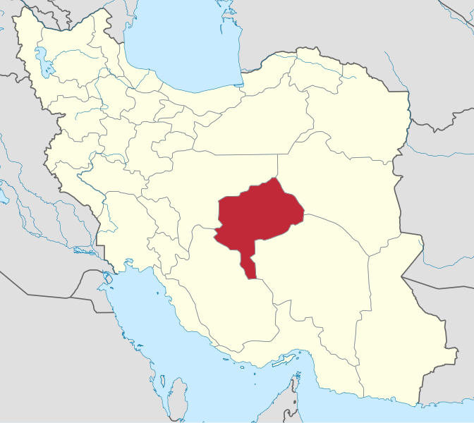
English: IranYazd |
| Date | |
| Source | Iran location map.svg |
| Author | Yamaha5 |
| SVG development |
Licensing[edit]
This file is licensed under the Creative Commons Attribution-Share Alike 3.0 Unported license.
- You are free:
- to share – to copy, distribute and transmit the work
- to remix – to adapt the work
- Under the following conditions:
- attribution – You must give appropriate credit, provide a link to the license, and indicate if changes were made. You may do so in any reasonable manner, but not in any way that suggests the licensor endorses you or your use.
- share alike – If you remix, transform, or build upon the material, you must distribute your contributions under the same or compatible license as the original.
File history
Click on a date/time to view the file as it appeared at that time.
| Date/Time | Thumbnail | Dimensions | User | Comment | |
|---|---|---|---|---|---|
| current | 02:36, 17 April 2017 | | 1,200 × 1,071 (470 KB) | Oganesson007 (talk | contribs) | Standard |
| 12:21, 23 June 2013 |  | 1,200 × 1,071 (303 KB) | BasilLeaf (talk | contribs) | بروزرسانی مرزها | |
| 10:54, 12 April 2013 |  | 1,200 × 1,071 (303 KB) | Yamaha5 (talk | contribs) | User created page with UploadWizard |
You cannot overwrite this file.
File usage on Commons
More than 100 pages use this file. The following list shows the first 100 pages that use this file only. A full list is available.
- File:IranYazd-SVG.svg (file redirect)
- File:IranYazd.png
- Category:Ab anbars in Yazd Province
- Category:Agricultural buildings in Yazd Province
- Category:Agriculture in Yazd Province
- Category:Animals of Yazd Province
- Category:Architectural elements in Yazd Province
- Category:Architecture of Yazd Province
- Category:Art of Yazd Province
- Category:Automobiles in Yazd Province
- Category:Baths in Yazd Province
- Category:Births in Yazd Province
- Category:Bodies of water in Yazd Province
- Category:Building interiors in Yazd Province
- Category:Buildings in Yazd Province
- Category:Caravanserais in Yazd Province
- Category:Castles in Yazd Province
- Category:Cemeteries in Yazd Province
- Category:Cisterns in Yazd Province
- Category:Cities in Yazd Province
- Category:Commerce buildings in Yazd Province
- Category:Commerce in Yazd Province
- Category:Counties of Yazd Province
- Category:Cultural buildings in Yazd Province
- Category:Culture of Yazd Province
- Category:Dams in Yazd Province
- Category:Dovecotes in Yazd Province
- Category:Education in Yazd Province
- Category:Events in Yazd Province
- Category:Flora of Yazd Province
- Category:Food in Yazd Province
- Category:Food shops in Yazd Province
- Category:Funerary buildings in Yazd Province
- Category:Gardens in Yazd Province
- Category:Geography of Yazd Province
- Category:Hammams in Yazd Province
- Category:Health in Yazd Province
- Category:History of Yazd Province
- Category:Hotels in Yazd Province
- Category:Houses in Yazd Province
- Category:Icehouses in Yazd Province
- Category:Industry buildings in Yazd Province
- Category:Industry in Yazd Province
- Category:Infrastructure in Yazd Province
- Category:Interiors in Yazd Province
- Category:Islam in Yazd Province
- Category:Lakes of Yazd Province
- Category:Land transport in Yazd Province
- Category:Landscape architecture in Yazd Province
- Category:Mausoleums in Yazd Province
- Category:Mosques in Yazd Province
- Category:Motorcycles in Yazd Province
- Category:Mountains of Yazd Province
- Category:Mourning of Muharram in Yazd Province
- Category:Museums in Yazd Province
- Category:Nature of Yazd Province
- Category:Palaces in Yazd Province
- Category:Pedestrian transport in Yazd Province
- Category:People of Yazd Province
- Category:Politics of Yazd Province
- Category:Populated places in Yazd Province
- Category:Public services in Yazd Province
- Category:Religion in Yazd Province
- Category:Religious buildings in Yazd Province
- Category:Residential buildings in Yazd Province
- Category:Restaurants in Yazd Province
- Category:Retail buildings in Yazd Province
- Category:Retail in Yazd Province
- Category:Rivers of Yazd Province
- Category:Road transport in Yazd Province
- Category:Road transport infrastructure in Yazd Province
- Category:Road vehicles in Yazd Province
- Category:Roads in Yazd Province
- Category:Sanitation in Yazd Province
- Category:Schools in Yazd Province
- Category:Shopping malls in Yazd Province
- Category:Shops in Yazd Province
- Category:Shrines in Yazd Province
- Category:Society of Yazd Province
- Category:Sports in Yazd Province
- Category:Squares in Yazd Province
- Category:Storage buildings in Yazd Province
- Category:Streets in Yazd Province
- Category:Tekiyehs in Yazd Province
- Category:Temples in Yazd Province
- Category:Tombs in Yazd Province
- Category:Tourism in Yazd Province
- Category:Towers in Yazd Province
- Category:Transport buildings in Yazd Province
- Category:Transport in Yazd Province
- Category:Transport infrastructure in Yazd Province
- Category:Trees in Yazd Province
- Category:Vehicles in Yazd Province
- Category:Villages in Yazd Province
- Category:Visitor attractions in Yazd Province
- Category:Walking in Yazd Province
- Category:Walking infrastructure in Yazd Province
- Category:Water in Yazd Province
- Category:Water supply in Yazd Province
- Category:Waterfalls in Yazd Province
View more links to this file.
File usage on other wikis
The following other wikis use this file:
- Usage on ar.wikipedia.org
- محافظات إيران
- يزد (محافظة)
- بافق
- أردكان
- أبر كوه
- تفت
- مهريز
- اشكذر
- حميديا
- أحمد أباد (يزد)
- ديهوك
- عشق أباد (طبس)
- هرات (يزد)
- مهردشت
- ندوشن
- نير (يزد)
- شاهديه
- زارتش
- عقدا
- خضر أباد (صدوق)
- اسفند أباد (اسفندار)
- أحمد أباد (تيرجرد)
- أسد أباد (اسفندار)
- أسد أباد السفلى (مهر أباد)
- أسد أباد العليا (مهر أباد)
- بند ميان (فراغة)
- بيداف (مهر أباد)
- تشاه بشير كارغر (مهر أباد)
- تشاه بنياد صدوق (اسفندار)
- تشاه جعفر أحمدي (اسفندار)
- تشاه حاج حسين (تيرجرد)
- تشاه حاج محمود (تيرجرد)
- تشاه رضا فرهمند (اسفندار)
- تشاه علي باقري (اسفندار)
- تشاه علي سربازي (اسفندار)
- تشاه علي ناجي (اسفندار)
- تشاه علي ناجي الثانية (اسفندار)
- تشاه محمد علي فرهمند (مهر أباد)
- تشاه محمد يزدي (مهر أباد)
- تشاه مهندس (مهر أباد)
- تشاه ناز أباد (فراغة)
- تقي أباد (اسفندار)
- تيجرد (أبركوه)
- تيزوك (تيرجرد)
- جلال أباد (فراغة)
- حسين أباد 17 (مهر أباد)
- حسين أباد 20 (مهر أباد)
- حشمت أباد (اسفندار)
- حميد أباد (فراغة)
- خرم أباد (اسفندار)
View more global usage of this file.