File:Kosovo 1941.png
Jump to navigation
Jump to search

Size of this preview: 515 × 600 pixels. Other resolutions: 206 × 240 pixels | 412 × 480 pixels | 663 × 772 pixels.
Original file (663 × 772 pixels, file size: 54 KB, MIME type: image/png)
Captions
Captions
Add a one-line explanation of what this file represents
Summary[edit]
| Description |
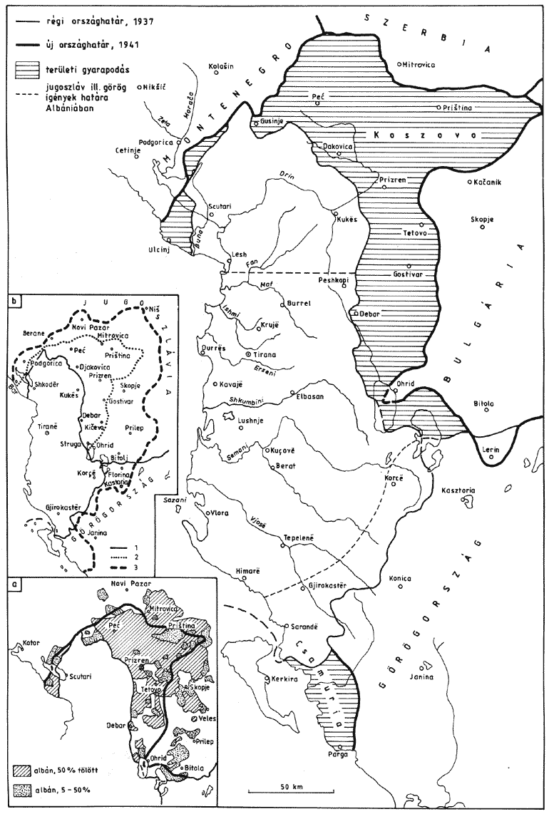
English: Division of modern-day territory of Kosovo between Axis states in 1941.
Українська: Косово, 1941 р. |
| Date | 2 June 2009 (original upload date) |
| Source | No machine-readable source provided. Own work assumed (based on copyright claims). |
| Author | PANONIAN |
Licensing[edit]
| I, the copyright holder of this work, release this work into the public domain. This applies worldwide. In some countries this may not be legally possible; if so: I grant anyone the right to use this work for any purpose, without any conditions, unless such conditions are required by law. |
References[edit]
- Istorijski atlas, Geokarta, Beograd, 1999.
- Denis Šehić - Demir Šehić, Istorijski atlas Sveta, Beograd, 2007.
- Školski istorijski atlas, Zavod za izdavanje udžbenika SR Srbije, Beograd, 1970.
- Sve srpske mape - od šestog veka do Pariza, Specijalno izdanje BLICA, Decembar 1995. godine.
- The Times History of Europe, Times Books, London, 2002.
- Richard Overy, The Times History of the 20th Century, Times Books, London, 2004.
- Dr Tomislav Bogavac, Nestajanje Srba, Niš, 1994.
- Noel Malcolm, Kosovo - A Short History, London, 2002.
- Džon R. Lempi, Jugoslavija kao istorija, Beograd, 2004.
- Tim Džuda, Srbi: istorija, mit i razaranje Jugoslavije, Beograd, 2003.
- Fransisko Veiga, Balkanska zamka (1804-2001), Beograd, 2003.
- Petrit Imami, Srbi i Albanci kroz vekove, Beograd, 2000.
- Peter Bartl, Albanci, Clio, Beograd, 2001.
- Valter Manošek, Holokaust u Srbiji, Beograd, 2007.
- Nenad Stefanović, Jedan Svet na Dunavu, Beograd, 2003.
- http://terkepek.adatbank.transindex.ro/kepek/netre/257.gif
- http://www.marxists.org/subject/yugoslavia/images/maps/1941-dismemberment.jpg
- http://lh6.ggpht.com/_WzQWv26EoIc/RlYxZ8QcGHI/AAAAAAAAAHw/poEpEv_g_0o/YU-Nazi-division.jpg
- http://www.svetskirat.net/slike/razbijanje/zazbijanje_jugoslavije_1941.jpg
- http://anamnesis.info/resources/Albania_during_WW2.gif
- http://tenc.net/kosovomap.jpg
File history
Click on a date/time to view the file as it appeared at that time.
| Date/Time | Thumbnail | Dimensions | User | Comment | |
|---|---|---|---|---|---|
| current | 19:46, 4 November 2012 | | 663 × 772 (54 KB) | PANONIAN (talk | contribs) | improved version |
| 17:13, 27 January 2010 |  | 665 × 857 (55 KB) | PANONIAN (talk | contribs) | aesthetics | |
| 07:23, 3 June 2009 |  | 665 × 857 (55 KB) | PANONIAN (talk | contribs) | ||
| 21:57, 2 June 2009 |  | 665 × 857 (51 KB) | PANONIAN (talk | contribs) | ==Description== Kosovo in 1941 ==Licence== self-made map by user:PANONIAN {{PD-self|PANONIAN}} Category:Maps of the history of Kosovo Category:Maps of Yugoslavia during World War II |
You cannot overwrite this file.
File usage on Commons
The following 2 pages use this file:
File usage on other wikis
The following other wikis use this file:
- Usage on af.wikipedia.org
- Usage on be.wikipedia.org
- Usage on br.wikipedia.org
- Usage on bs.wikipedia.org
- Usage on de.wikipedia.org
- Usage on en.wikipedia.org
- Usage on es.wikipedia.org
- Usage on et.wikipedia.org
- Usage on fr.wikipedia.org
- Usage on gl.wikipedia.org
- Usage on hr.wikipedia.org
- Usage on hu.wikipedia.org
- Usage on it.wikipedia.org
- Usage on ja.wikipedia.org
- Usage on la.wikipedia.org
- Usage on lv.wikipedia.org
- Usage on mk.wikipedia.org
- Usage on no.wikipedia.org
- Usage on pl.wikipedia.org
- Usage on pt.wikipedia.org
- Usage on ru.wikipedia.org
- Usage on sh.wikipedia.org
- Usage on sv.wikipedia.org
- Usage on tr.wikipedia.org
- Usage on uk.wikipedia.org