File:Czechia-geographic map-fr.svg
Jump to navigation
Jump to search

Size of this PNG preview of this SVG file: 800 × 493 pixels. Other resolutions: 320 × 197 pixels | 640 × 394 pixels | 1,024 × 630 pixels | 1,280 × 788 pixels | 2,560 × 1,576 pixels | 1,949 × 1,200 pixels.
Original file (SVG file, nominally 1,949 × 1,200 pixels, file size: 14.56 MB)
Captions
Captions
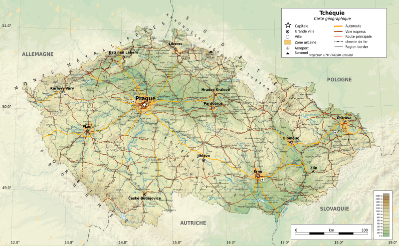
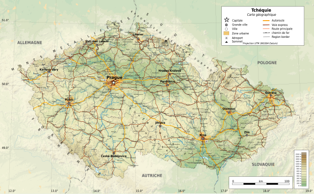
Geographical map of Czechia
Summary[edit]
| Description |
Français : Carte géographique de la f fr:Tchéquie.
English: Geographical map of Czechia
Čeština: Geografická mapa Česka |
| Date | |
| Source | CzechRepublic-geographic map-fr.svg |
| Author |
Touam Edited by Martin Tauchman |
Licensing[edit]
This file is licensed under the Creative Commons Attribution-Share Alike 4.0 International license.
- You are free:
- to share – to copy, distribute and transmit the work
- to remix – to adapt the work
- Under the following conditions:
- attribution – You must give appropriate credit, provide a link to the license, and indicate if changes were made. You may do so in any reasonable manner, but not in any way that suggests the licensor endorses you or your use.
- share alike – If you remix, transform, or build upon the material, you must distribute your contributions under the same or compatible license as the original.
File history
Click on a date/time to view the file as it appeared at that time.
| Date/Time | Thumbnail | Dimensions | User | Comment | |
|---|---|---|---|---|---|
| current | 13:18, 1 June 2021 | | 1,949 × 1,200 (14.56 MB) | Martin Tauchman (talk | contribs) | Uploaded a work by Touam Edited by Martin Tauchman from File:CzechRepublic-geographic map-fr.svg with UploadWizard |
You cannot overwrite this file.
File usage on Commons
The following 2 pages use this file:
File usage on other wikis
The following other wikis use this file:
- Usage on fr.wikipedia.org
- Usage on gcr.wikipedia.org