File:Norderney Landsat7.png
Jump to navigation
Jump to search

Size of this preview: 800 × 278 pixels. Other resolutions: 320 × 111 pixels | 1,152 × 400 pixels.
Original file (1,152 × 400 pixels, file size: 522 KB, MIME type: image/png)
Captions
Captions
Add a one-line explanation of what this file represents
Summary[edit]
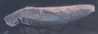
Deutsch: Aufnahme der deutschen Insel Norderney durch Community Landsat 7.
English: Picture of german island Norderney taken by Community Landsat 7.
Source: NASA World Wind, originally uploaded to de:Bild:Landsat7ney.png by de:Benutzer:Elvaube: 17:47, 21. Jul 2005 . . Elvaube . . 1152 x 400 (534483 Byte) (Beschreibung: Community Landsat 7 Aufnahme von Norderney Quelle: NASA World Wind Lizenz: public domain)
Licensing[edit]
| This image is in the public domain because it is a screenshot from NASA’s globe software World Wind using a public domain layer, such as Blue Marble, MODIS, Landsat, SRTM, USGS or GLOBE.
|
 |
File history
Click on a date/time to view the file as it appeared at that time.
| Date/Time | Thumbnail | Dimensions | User | Comment | |
|---|---|---|---|---|---|
| current | 19:42, 29 December 2005 | 1,152 × 400 (522 KB) | Dabbelju (talk | contribs) | ==Description== {{de|Aufnahme der deutschen Insel Norderney durch Community Landsat 7.}} {{en|Picture of german island Norderney taken by Community Landsat 7.}} '''Source:''' NASA World Wind, originally uploaded to de:Bild:Landsat7ney.png b |
You cannot overwrite this file.
File usage on Commons
The following page uses this file:
File usage on other wikis
The following other wikis use this file:
- Usage on cs.wikipedia.org
- Usage on de.wikipedia.org
- Usage on eo.wikipedia.org
- Usage on fy.wikipedia.org
- Usage on hy.wikipedia.org
- Usage on nn.wikipedia.org
- Usage on simple.wikipedia.org
- Usage on vi.wikipedia.org