File:Francoprovencal-Geo-Map-1.jpg
Jump to navigation
Jump to search
No higher resolution available.
Francoprovencal-Geo-Map-1.jpg (473 × 473 pixels, file size: 211 KB, MIME type: image/jpeg)
Captions
Captions
Add a one-line explanation of what this file represents

|
This linguistic map image could be re-created using vector graphics as an SVG file. This has several advantages; see Commons:Media for cleanup for more information. If an SVG form of this image is available, please upload it and afterwards replace this template with
{{vector version available|new image name}}.
It is recommended to name the SVG file “Francoprovencal-Geo-Map-1.svg”—then the template Vector version available (or Vva) does not need the new image name parameter. |


Summary[edit]
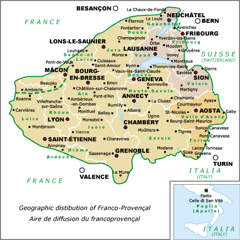
| Description | Franco-Provençal language map showing cities & political divisions, Revision 1 | ||
| Date | |||
| Source | self-made, after: Tuaillon, G.(1972), "Le francoprovençal. Progrès d'une définition", in Travaux de Linguistique et de littérature X, 1, p. 337 | ||
| Author | Charvex | ||
| Permission (Reusing this file) |
|
||
| Other versions | Replacement for Francoprovencal-Geo-Map.jpg |
File history
Click on a date/time to view the file as it appeared at that time.
| Date/Time | Thumbnail | Dimensions | User | Comment | |
|---|---|---|---|---|---|
| current | 10:32, 7 December 2007 | | 473 × 473 (211 KB) | Charvex (talk | contribs) | {{Information |Description=Franco-Provençal language map showing cities & political divisions, Revision 1 |Source=self-made |Date=7 December 2007 |Author= Charvex |Permission=Public Domain |other_versions=Replacement for Francoprovencal- |
You cannot overwrite this file.
File usage on Commons
There are no pages that use this file.
File usage on other wikis
The following other wikis use this file:
- Usage on en.wikipedia.org
- Usage on frp.wikipedia.org
- Usage on sq.wikipedia.org
- Usage on vec.wikipedia.org
- Usage on zh.wikipedia.org