File:Total Fertility Rate Map by Country.svg
Jump to navigation
Jump to search

Size of this PNG preview of this SVG file: 800 × 410 pixels. Other resolutions: 320 × 164 pixels | 640 × 328 pixels | 1,024 × 525 pixels | 1,280 × 656 pixels | 2,560 × 1,312 pixels | 1,104 × 566 pixels.
Original file (SVG file, nominally 1,104 × 566 pixels, file size: 1.68 MB)
Captions
Captions
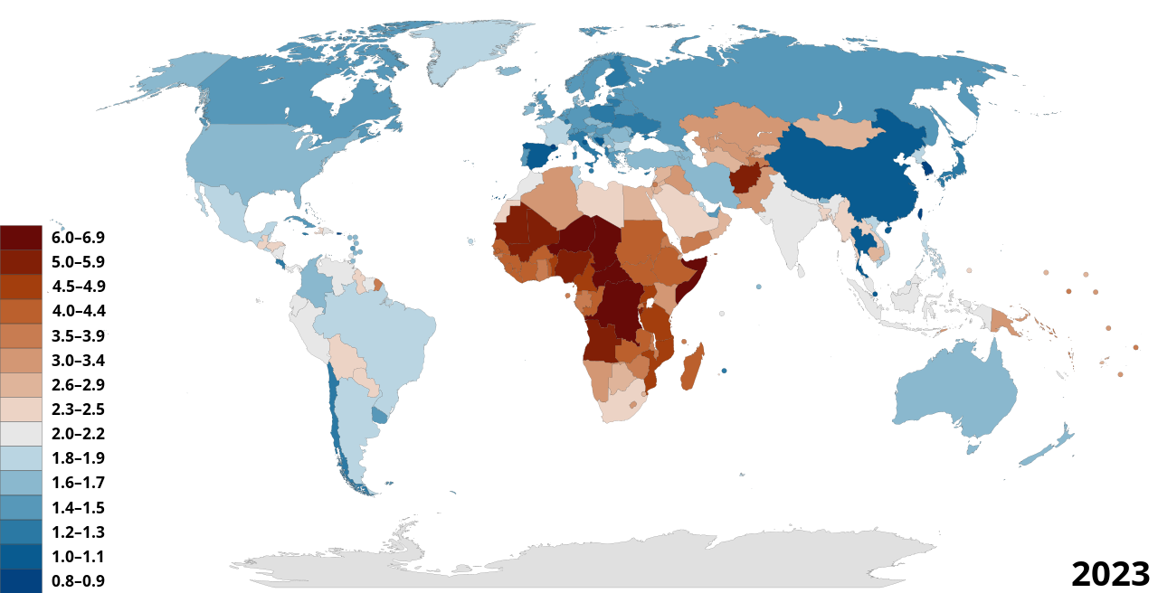
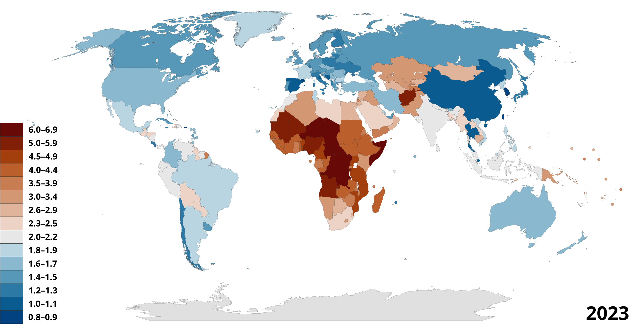
Global map of total fertility rates by country

|
This file may be updated to reflect new information. If you wish to use a specific version of the file without new updates being mirrored, please upload the required version as a separate file. |
Summary[edit]
| Description |
English: Total fertility rates of sovereign states plus Greenland, French Guiana, New Caledonia, and Puerto Rico.
Data from Population Reference Bureau's World Population Data Sheet. Greenland data from CIA Factbook. Derived from BlankMap-World-Sovereign_Nations by RedGolpe. Crimea status in data unknown, I've gone with default of the original map. Total fertility rates on the left refer to the average number of children that are born to a woman over her lifetime. |
| Date | |
| Source | Own work |
| Author | Korakys |
Licensing[edit]
I, the copyright holder of this work, hereby publish it under the following license:
This file is licensed under the Creative Commons Attribution-Share Alike 4.0 International license.
- You are free:
- to share – to copy, distribute and transmit the work
- to remix – to adapt the work
- Under the following conditions:
- attribution – You must give appropriate credit, provide a link to the license, and indicate if changes were made. You may do so in any reasonable manner, but not in any way that suggests the licensor endorses you or your use.
- share alike – If you remix, transform, or build upon the material, you must distribute your contributions under the same or compatible license as the original.
File history
Click on a date/time to view the file as it appeared at that time.
| Date/Time | Thumbnail | Dimensions | User | Comment | |
|---|---|---|---|---|---|
| current | 08:51, 7 January 2024 | | 1,104 × 566 (1.68 MB) | Korakys (talk | contribs) | Changed colour scheme to vik100 scientific colours. |
| 07:01, 19 December 2023 |  | 1,104 × 566 (1.68 MB) | Korakys (talk | contribs) | Updated to 2023 figures. | |
| 04:01, 17 August 2023 |  | 1,104 × 566 (1.68 MB) | Korakys (talk | contribs) | Updated Greenland. | |
| 03:36, 17 August 2023 |  | 1,104 × 566 (1.68 MB) | Korakys (talk | contribs) | Changed colour scheme to a two shade method. Designed to provide better descrimination at a regional level. Added year legend to indicate data age. | |
| 11:09, 4 September 2022 |  | 1,104 × 566 (1.68 MB) | Korakys (talk | contribs) | Updated to 2022 PRB figures, removed middle orange colour and therefore retinted the other two orange shades | |
| 04:07, 19 August 2021 |  | 1,104 × 566 (1.68 MB) | Korakys (talk | contribs) | Updated to 2021 data. Colours tweaked to increase contrast. | |
| 08:23, 22 August 2020 |  | 1,104 × 566 (1.68 MB) | Korakys (talk | contribs) | Moved the key labels outside the key colour boxes to improve readability. | |
| 20:37, 16 August 2020 |  | 1,104 × 566 (1.68 MB) | Korakys (talk | contribs) | Enlarged key, tweaked colours once again. | |
| 11:25, 15 August 2020 |  | 1,104 × 566 (1.68 MB) | Korakys (talk | contribs) | Further updated colour scheme. | |
| 10:47, 15 August 2020 |  | 1,104 × 566 (1.68 MB) | Korakys (talk | contribs) | Updated colour scheme |
You cannot overwrite this file.
File usage on Commons
The following 3 pages use this file:
File usage on other wikis
The following other wikis use this file:
- Usage on ar.wikipedia.org
- Usage on as.wikipedia.org
- Usage on bcl.wikipedia.org
- Usage on be.wikipedia.org
- Usage on bg.wikipedia.org
- Usage on bn.wikipedia.org
- Usage on bs.wikipedia.org
- Usage on ceb.wikipedia.org
- Usage on da.wikipedia.org
- Usage on de.wikipedia.org
- Usage on el.wikipedia.org
- Usage on en.wikipedia.org
- Woman
- Poverty
- Infant mortality
- Human population planning
- Developing country
- Mother
- Family planning
- Fertility
- Total fertility rate
- Sub-replacement fertility
- Population decline
- Population pyramid
- Gender equality
- List of countries by total fertility rate
- Poverty in Africa
- Sexual and reproductive health
- Human overpopulation
- Demographics of Africa
- Maternal health
- Family
- Birth control
- World population
- Family planning in India
- Projections of population growth
- Portal:Countries
- Generation Alpha
- Sustainable population
- User:Lexsta/sandbox
- Demographics of Generation Alpha
- Usage on en.wikibooks.org
- Usage on eu.wikipedia.org
- Usage on fa.wikipedia.org
View more global usage of this file.