File:Religious denominations in Germany, 2011 Census, self-identification of the population.svg

Original file (SVG file, nominally 744 × 1,052 pixels, file size: 9.66 MB)
Captions
Captions
Summary[edit]
| Description |
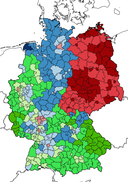
English: Green the Catholic Church, Blue is for the Evangelical Church while Red indicated people who don't belong to any religion.
Lighter shades indicate a relative majority (the largest confession comprises less than 50%), dark shades indicate an absolute majority between 50 and 75% and the darkest shades indicate an absolute majority over 75%. The data comes from the 2011 Census of Germany using the self-identification question, and thus the map doesn't show the official church membership data of the two major churches, but rather how the population felt to identify. The data can be gathered from the following link manually adding the geographies or by asking the german Federal Bureau of Statistics for a ready-made excel table. The data was then imported into QGIS using the shapefile of Germany as of the 1st January, 2011 and then the map was exported as an .SVG file.Italiano: In verde la Chiesa Cattolica, in blue la Chiesa Evangelica Tedesca mentre in Rosso chi non appartiene a nessuna religione.
Sfumature più chiare indicano una maggioranza relativa (la confessione più grande comprende meno del 50% della popolazione), le sfumature scure indicano una maggioranza relativa (dal 50 al 75%) mentre le sfumature più scure indicano una maggioranza relativa con più del 75%. I dati provengono dal censimento tedesco del 2011, utilizzando la domanda basata sull'autoidentificazione, e quindi la mappa non mostra il numero dei membri ufficiali delle due chiese principali, ma come la popolazione si sente di appartenere. I dati possono essere ottenuti dal seguente collegamento aggiungendo manualmente le variabili geografiche, o chiedendo all'Ufficio di Statistica Federale una tabella già pronta. I dati sono poi stati importati nel programma QGIS utilizzando il file geografico della Germania del primo gennaio 2011, e successivamente la mappa è stata esportata in formato .SVG |
| Date | |
| Source | Own work |
| Author | FrankCesco26 |
Licensing[edit]
- You are free:
- to share – to copy, distribute and transmit the work
- to remix – to adapt the work
- Under the following conditions:
- attribution – You must give appropriate credit, provide a link to the license, and indicate if changes were made. You may do so in any reasonable manner, but not in any way that suggests the licensor endorses you or your use.
- share alike – If you remix, transform, or build upon the material, you must distribute your contributions under the same or compatible license as the original.
File history
Click on a date/time to view the file as it appeared at that time.
| Date/Time | Thumbnail | Dimensions | User | Comment | |
|---|---|---|---|---|---|
| current | 16:03, 4 September 2019 | | 744 × 1,052 (9.66 MB) | FrankCesco26 (talk | contribs) | User created page with UploadWizard |
You cannot overwrite this file.
File usage on Commons
There are no pages that use this file.
File usage on other wikis
The following other wikis use this file:
- Usage on el.wikipedia.org
- Usage on en.wikipedia.org
- Usage on fa.wikipedia.org
- Usage on fi.wikipedia.org
- Usage on fr.wikipedia.org
- Usage on ko.wikipedia.org
- Usage on ku.wikipedia.org
- Usage on mt.wikipedia.org
- Usage on sq.wikipedia.org
- Usage on tr.wikipedia.org
- Usage on uk.wikipedia.org