File:911 - FEMA - WTC impacts (graphic).svg
Jump to navigation
Jump to search

Size of this PNG preview of this SVG file: 744 × 501 pixels. Other resolutions: 320 × 215 pixels | 640 × 431 pixels | 1,024 × 690 pixels | 1,280 × 862 pixels | 2,560 × 1,724 pixels.
Original file (SVG file, nominally 744 × 501 pixels, file size: 127 KB)
Captions
Captions
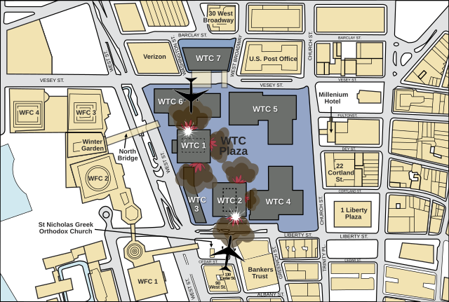
A top-down diagram showing the area surrounding the WTC, and how the planes hit the towers on 9/11/2001.
Summary[edit]
.svg&action=edit§ion=1)
| Description |
English: Illustrative guide to the relative positioning of the planes that caused the 9/11 disaster. |
| Date | |
| Source | FEMA (Page 5) |
| Author | Fred the Oyster |
| Other versions |
.png) |
| SVG development | This map was created with Adobe Illustrator. |
Licensing[edit]
.svg&action=edit§ion=2)
This image is a work of a Federal Emergency Management Agency employee, taken or made as part of that person's official duties. As works of the U.S. federal government, all FEMA images are in the public domain in the United States. Additional media usage information may be found at https://www.fema.gov/photo-video-audio-use-guidelines
|
File history
Click on a date/time to view the file as it appeared at that time.
| Date/Time | Thumbnail | Dimensions | User | Comment | |
|---|---|---|---|---|---|
| current | 04:19, 11 September 2022 | | 744 × 501 (127 KB) | YitzhakNat (talk | contribs) | using inkscapeː update fonts, improve text visibility |
| 01:57, 23 August 2021 |  | 744 × 501 (93 KB) | Praça de Maio (talk | contribs) | File uploaded using svgtranslate tool (https://svgtranslate.toolforge.org/). Added translation for tr. | |
| 20:36, 10 December 2011 |  | 744 × 501 (83 KB) | Fred the Oyster (talk | contribs) | correct building name | |
| 23:04, 28 October 2011 |  | 744 × 501 (83 KB) | Fred the Oyster (talk | contribs) | change font face name | |
| 22:39, 28 October 2011 |  | 744 × 501 (83 KB) | Fred the Oyster (talk | contribs) | =={{int:filedesc}}== {{Information |Description ={{en|1=Illustrative guide to the relative positioning of the planes that caused the 9/11 disaster.}} |Source =[http://www.fema.gov/pdf/library/fema403_ch1.pdf FEMA] (Page 5) |Author =[[Us |
You cannot overwrite this file.
File usage on Commons
The following page uses this file:
File usage on other wikis
The following other wikis use this file:
- Usage on bg.wikipedia.org
- Usage on br.wikipedia.org
- Usage on cs.wikipedia.org
- Usage on da.wikipedia.org
- Usage on de.wikipedia.org
- Usage on el.wikipedia.org
- Usage on en.wikipedia.org
- Usage on en.wikiquote.org
- Usage on fa.wikipedia.org
- Usage on fr.wikipedia.org
- Usage on hi.wikipedia.org
- Usage on hu.wikipedia.org
- Usage on hy.wikipedia.org
- Usage on it.wikipedia.org
- Usage on ja.wikipedia.org
- Usage on ko.wikipedia.org
- Usage on ms.wikipedia.org
- Usage on my.wikipedia.org
- Usage on nn.wikipedia.org
- Usage on pl.wikipedia.org
- Usage on pt.wikipedia.org
- Usage on ru.wikipedia.org
- Usage on sr.wikipedia.org
- Usage on vi.wikipedia.org
- Usage on yo.wikipedia.org
- Usage on zh.wikipedia.org
.svg&oldid=771492226)