File:Soviet caucasus1922.png
Jump to navigation
Jump to search

Size of this preview: 800 × 571 pixels. Other resolutions: 320 × 229 pixels | 640 × 457 pixels | 1,024 × 731 pixels | 1,280 × 914 pixels | 1,613 × 1,152 pixels.
Original file (1,613 × 1,152 pixels, file size: 127 KB, MIME type: image/png)
Captions
Captions
Add a one-line explanation of what this file represents
Summary[edit]
| Description |
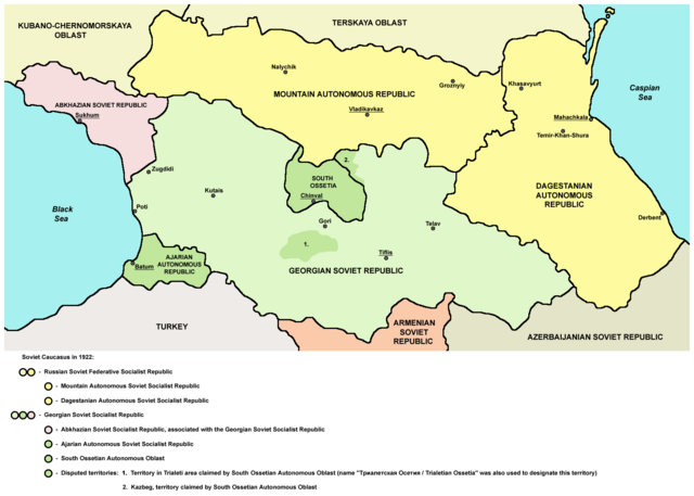
English: Northern part of Soviet Caucasus in 1922 - Mountain Autonomous Soviet Socialist Republic, Dagestanian Autonomous Soviet Socialist Republic, Georgian Soviet Socialist Republic, Abkhazian Soviet Socialist Republic, Ajarian Autonomous Soviet Socialist Republic, South Ossetian Autonomous Oblast and disputed territories claimed by South Ossetian Autonomous Oblast (Trialeti area / Trialetian Ossetia and Kazbeg). |
| Date | |
| Source | Own work |
| Author | PANONIAN |
| Other versions |
|

Licensing[edit]
| I, the copyright holder of this work, release this work into the public domain. This applies worldwide. In some countries this may not be legally possible; if so: I grant anyone the right to use this work for any purpose, without any conditions, unless such conditions are required by law. |
References[edit]
Made according to these sources:
- http://www.iriston.com/books/cuciev_-_etno_atlas/cuciev_etno-polit_map.htm - 50 maps from book "АТЛАС ЭТНОПОЛИТИЧЕСКОЙ ИСТОРИИ КАВКАЗА", Цуциев А.А, Москва: Издательство «Европа», 2007. ("Atlas of ethnopolitical history of Caucasus", Tsutsiev A.A, Moscow: Publisher «Evropa», 2007), inluding a map of Soviet Caucasus in 1921, which show Mountain Autonomous Soviet Socialist Republic, Dagestanian Autonomous Soviet Socialist Republic, Georgian Soviet Socialist Republic, Abkhazian Soviet Socialist Republic, Ajarian Autonomous Soviet Socialist Republic, and disputed territories inhabited by Ossetians: South Ossetia, Trialetian Ossetia and Kazbeg.
- http://dic.academic.ru/pictures/wiki/files/84/Tsutsiev.jpg - map from book "АТЛАС ЭТНОПОЛИТИЧЕСКОЙ ИСТОРИИ КАВКАЗА", Цуциев А.А ("Atlas of ethnopolitical history of Caucasus", Tsutsiev A.A), inluding a map of Soviet Caucasus in 1921, which show Mountain Autonomous Soviet Socialist Republic, Dagestanian Autonomous Soviet Socialist Republic, Georgian Soviet Socialist Republic, Abkhazian Soviet Socialist Republic, Ajarian Autonomous Soviet Socialist Republic, and disputed territories inhabited by Ossetians: South Ossetia, Trialetian Ossetia and Kazbeg.
- http://www.iriston.com/nogbon/pictures/Tabol/cuciev_karta_6.jpg - map of Soviet Caucasus in 1922, created by Tsutsiev A.A, which show Mountain Autonomous Soviet Socialist Republic and South Ossetian Autonomous Oblast.
File history
Click on a date/time to view the file as it appeared at that time.
| Date/Time | Thumbnail | Dimensions | User | Comment | |
|---|---|---|---|---|---|
| current | 17:03, 26 December 2015 | | 1,613 × 1,152 (127 KB) | PANONIAN (talk | contribs) | Reverted to version as of 14:47, 27 March 2010 (UTC) - please upload your version under different filename |
| 10:56, 26 December 2015 |  | 1,613 × 1,090 (115 KB) | Ercwlff (talk | contribs) | corrected georgian city names | |
| 10:45, 26 December 2015 |  | 1,613 × 1,090 (114 KB) | Ercwlff (talk | contribs) | corrected | |
| 10:42, 26 December 2015 |  | 1,613 × 1,090 (117 KB) | Ercwlff (talk | contribs) | ~~~~ | |
| 14:47, 27 March 2010 |  | 1,613 × 1,152 (127 KB) | PANONIAN (talk | contribs) | on the second thought, this map is focused on the history of Ossetians and other north Caucasian peoples and therefore disputes areas claimed by Armenia and Azerbaijan are not very relevant subject here | |
| 22:04, 26 March 2010 |  | 1,613 × 1,216 (134 KB) | PANONIAN (talk | contribs) | corrected one description | |
| 22:54, 25 March 2010 |  | 1,613 × 1,216 (132 KB) | PANONIAN (talk | contribs) | new version | |
| 23:52, 23 March 2010 |  | 1,613 × 1,122 (121 KB) | PANONIAN (talk | contribs) | correction | |
| 18:51, 23 March 2010 |  | 1,613 × 1,122 (121 KB) | PANONIAN (talk | contribs) | significant improvement - I hope that this is a final version | |
| 16:32, 23 March 2010 |  | 1,227 × 915 (88 KB) | PANONIAN (talk | contribs) | corrections |
You cannot overwrite this file.
File usage on Commons
The following 8 pages use this file:
File usage on other wikis
The following other wikis use this file:
- Usage on ar.wikipedia.org
- Usage on ast.wikipedia.org
- Usage on bg.wikipedia.org
- Usage on bn.wikipedia.org
- Usage on br.wikipedia.org
- Usage on ca.wikipedia.org
- Usage on ce.wikipedia.org
- Usage on de.wikipedia.org
- Usage on en.wikipedia.org
- Usage on eo.wikipedia.org
- Usage on es.wikipedia.org
- Usage on et.wikipedia.org
- Usage on fi.wikipedia.org
- Usage on fr.wikipedia.org
- Usage on it.wikipedia.org
- Usage on ja.wikipedia.org
- Usage on kk.wikipedia.org
- Usage on ko.wikipedia.org
- Usage on ku.wikipedia.org
- Usage on lt.wikipedia.org
- Usage on lv.wikipedia.org
- Usage on mk.wikipedia.org
- Usage on no.wikipedia.org
- Usage on os.wikipedia.org
- Usage on pl.wikipedia.org
View more global usage of this file.
Categories:
- Maps of the history of the Caucasus under Soviet rule
- Maps of the history of Russia
- Maps of the history of Karachay-Cherkessia
- Maps of the history of Kabardino-Balkaria
- Maps of the history of North Ossetia – Alania
- Maps of the history of Chechnya
- Maps of the history of Dagestan
- Maps of the history of Georgia
- Maps of the history of Abkhazia
- Maps of the history of Ajaria
- Maps of the history of South Ossetia
- Maps of the Georgian Soviet Socialist Republic
- 1922 maps
- Maps of the Caucasus by some users