File:Map of Tallinn, 1810.jpg
Jump to navigation
Jump to search

Size of this preview: 747 × 600 pixels. Other resolutions: 299 × 240 pixels | 598 × 480 pixels | 957 × 768 pixels | 1,276 × 1,024 pixels | 1,748 × 1,403 pixels.
Original file (1,748 × 1,403 pixels, file size: 1.7 MB, MIME type: image/jpeg)
Captions
Captions
Add a one-line explanation of what this file represents
Summary[edit]
| Description |
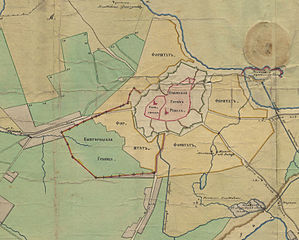
English: Extract from a 1810 map of Tallinn, showing the borders of Toompea and the rest of town.
Toompea (Вышгородъ) on the left, Tallinn (Lower Town - Губернской Городъ Ревелъ) on the right. Border of the territory of Toompea is shown with a red line (Вышгородцкая Граница). Русский: Специальная геометрическая карта, показывающая границы губернского города Ревеля, в которой означены также границы наследственно городу принадлежащей мыза Габерст и городских выгонов и сенокосов. 1810 |
|||||||||
| Date | ||||||||||
| Source | Collection of plans and maps of Tallinn City Archives: [1] | |||||||||
| Creator |
Unknown author |
|||||||||
| Geotemporal data | ||||||||||
| Bounding box |
|
|||||||||
| Georeferencing | ||||||||||
Licensing[edit]
|
This is a faithful photographic reproduction of a two-dimensional, public domain work of art. The work of art itself is in the public domain for the following reason:
The official position taken by the Wikimedia Foundation is that "faithful reproductions of two-dimensional public domain works of art are public domain".
This photographic reproduction is therefore also considered to be in the public domain in the United States. In other jurisdictions, re-use of this content may be restricted; see Reuse of PD-Art photographs for details. | ||||
File history
Click on a date/time to view the file as it appeared at that time.
| Date/Time | Thumbnail | Dimensions | User | Comment | |
|---|---|---|---|---|---|
| current | 22:49, 16 December 2009 | | 1,748 × 1,403 (1.7 MB) | Hannu~commonswiki (talk | contribs) | {{Information |Description={{en|1=Extract from a 1810 map of Tallinn, showing the borders of Toompea and the rest of town.}} {{ru|1=Специальная геометрическая карта, показывающая г |
You cannot overwrite this file.
File usage on Commons
The following page uses this file:
File usage on other wikis
The following other wikis use this file:
- Usage on de.wikipedia.org
- Usage on en.wikipedia.org
- Usage on es.wikipedia.org
- Usage on et.wikipedia.org
- Usage on it.wikipedia.org
- Usage on ro.wikipedia.org
- Usage on sl.wikipedia.org
- Usage on sr.wikipedia.org
- Usage on uk.wikipedia.org