File:OrteliusWorldMap.jpeg
Jump to navigation
Jump to search
Size of this preview: 800 × 545 pixels. Other resolutions: 320 × 218 pixels | 640 × 436 pixels | 1,024 × 697 pixels | 1,280 × 872 pixels | 2,560 × 1,744 pixels | 5,788 × 3,942 pixels.
Original file (5,788 × 3,942 pixels, file size: 26.95 MB, MIME type: image/jpeg)
Captions
Captions
Add a one-line explanation of what this file represents
Summary[edit]
| Description |
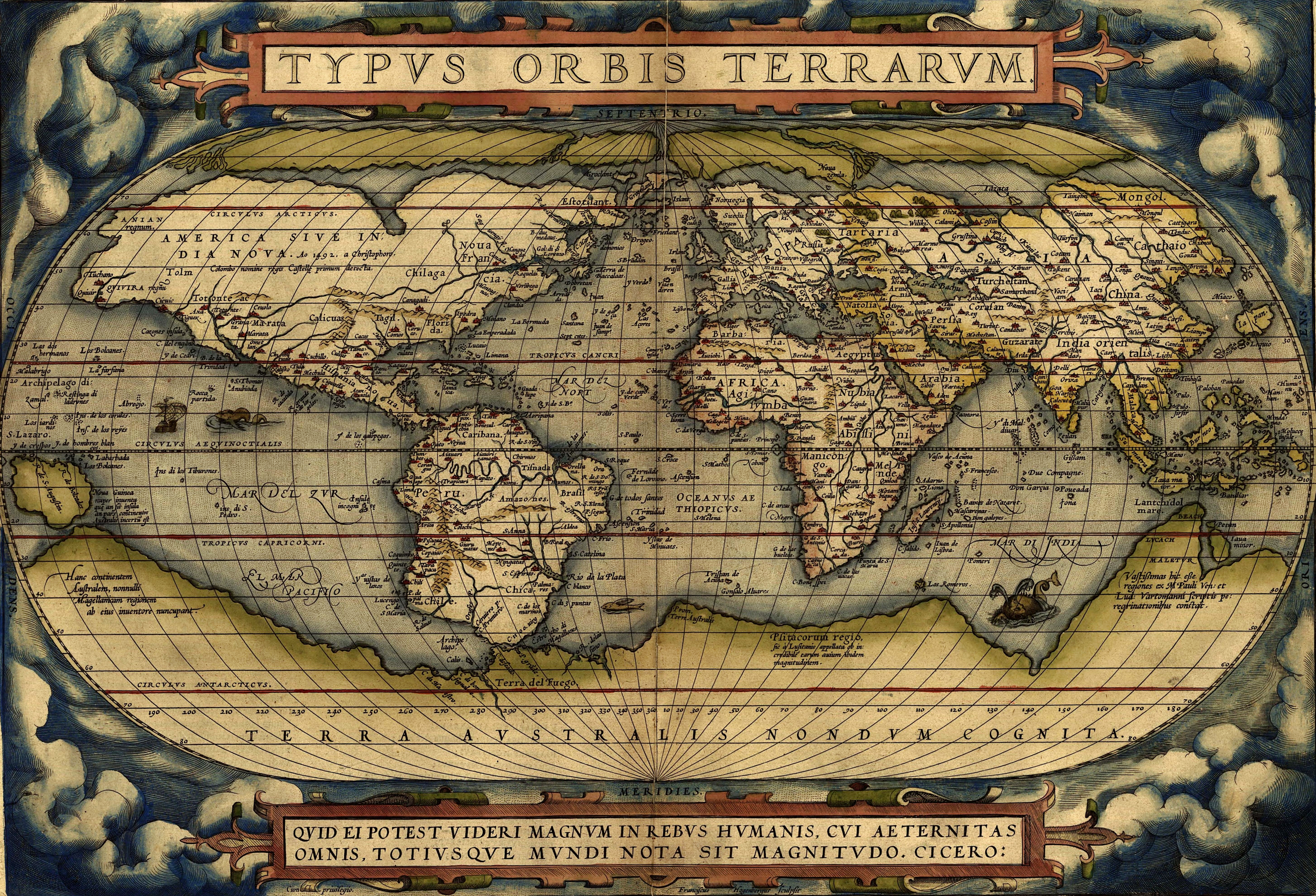
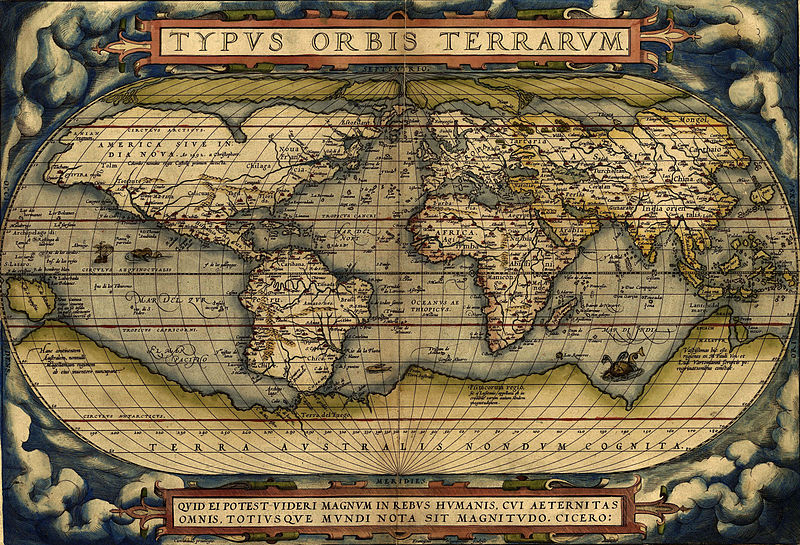
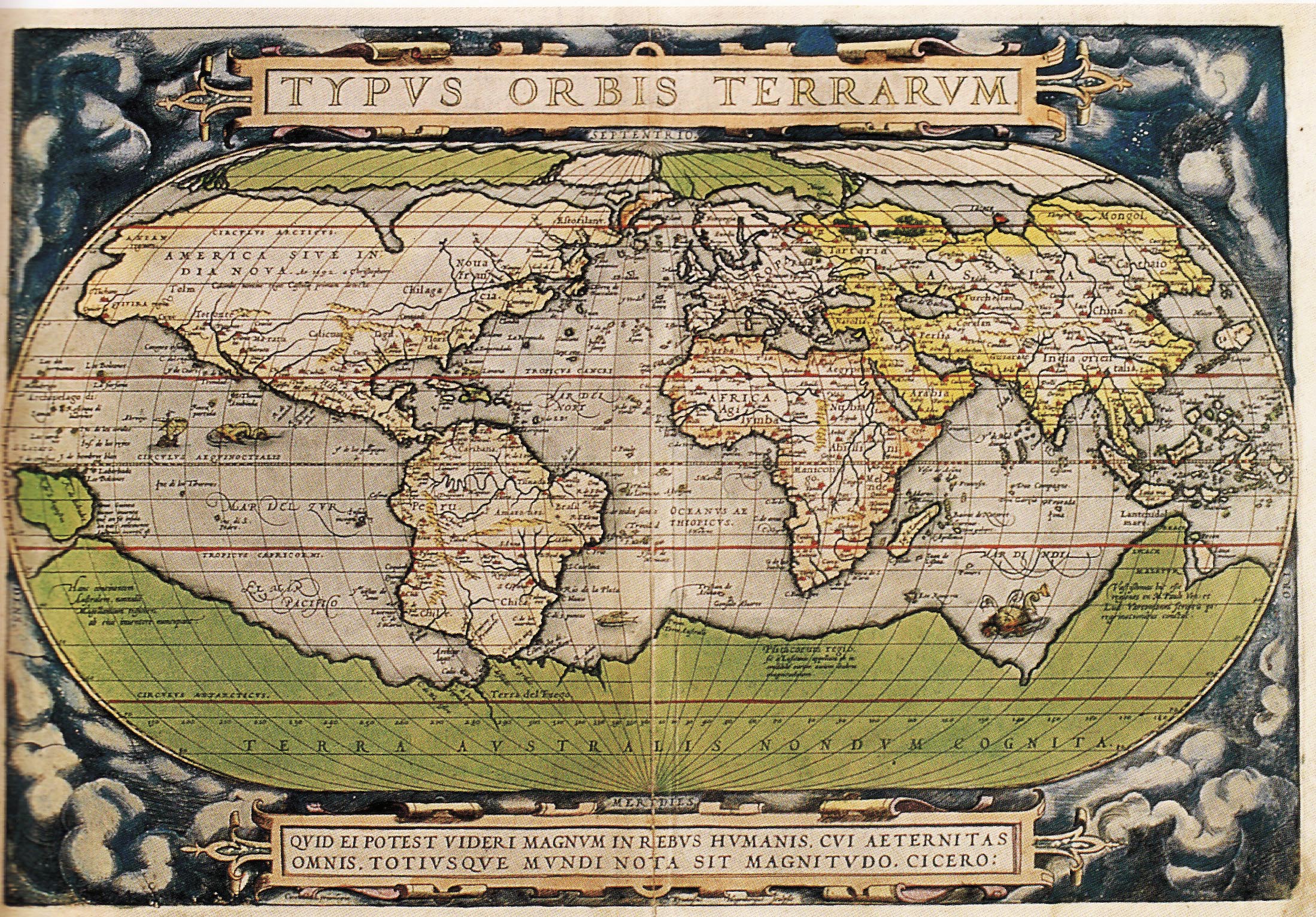
English: Ortelius world map 1570
Español: Mapa Mundial de Ortelius, 1570
Türkçe: Ortelius'un dünya haritası, 1570
עברית: מפת העולם מתוך אטלס אורטליוס |
|||||||||||||||||||||||
| Date | ||||||||||||||||||||||||
| Source | http://www.britishempire.co.uk/images4/ortelius1570maplarge.jpg | |||||||||||||||||||||||
| Author |
|
|||||||||||||||||||||||

Licensing[edit]
|
This is a faithful photographic reproduction of a two-dimensional, public domain work of art. The work of art itself is in the public domain for the following reason:
The official position taken by the Wikimedia Foundation is that "faithful reproductions of two-dimensional public domain works of art are public domain".
This photographic reproduction is therefore also considered to be in the public domain in the United States. In other jurisdictions, re-use of this content may be restricted; see Reuse of PD-Art photographs for details. | ||||
File history
Click on a date/time to view the file as it appeared at that time.
| Date/Time | Thumbnail | Dimensions | User | Comment | |
|---|---|---|---|---|---|
| current | 08:37, 1 February 2015 | | 5,788 × 3,942 (26.95 MB) | Hello world (talk | contribs) | new |
| 08:30, 1 February 2015 |  | 2,198 × 1,532 (6.79 MB) | Hello world (talk | contribs) | new | |
| 08:23, 1 February 2015 |  | 2,198 × 1,532 (6.79 MB) | Hello world (talk | contribs) | new | |
| 11:46, 13 June 2005 |  | 616 × 424 (100 KB) | ¡0-8-15! (talk | contribs) | Ortelius world map 1570 {{PD-Old}} |
You cannot overwrite this file.
File usage on Commons
More than 100 pages use this file. The following list shows the first 100 pages that use this file only. A full list is available.
- Facsimile atlas
- Maps of the world
- Old maps
- User:Kanchelskis/Atlante
- File:1570 Typus Ortelius mr.jpg
- File:1572 Typus Orbis Terrarum Ortelius.jpg
- File:OrteliusWorldMap1570.jpg
- Category:Geography
- Category:Geography by country
- Category:Geography of Aachen
- Category:Geography of Alagoas
- Category:Geography of Almaty Region
- Category:Geography of Anhui
- Category:Geography of Athens
- Category:Geography of Biscay
- Category:Geography of Cantabria
- Category:Geography of Chhattisgarh
- Category:Geography of Crimea
- Category:Geography of Dadra and Nagar Haveli and Daman and Diu
- Category:Geography of Dagestan
- Category:Geography of Delhi
- Category:Geography of Dublin
- Category:Geography of Finnmark
- Category:Geography of Friesland
- Category:Geography of Fujian
- Category:Geography of Gansu
- Category:Geography of Goiás
- Category:Geography of Guangxi
- Category:Geography of Guizhou
- Category:Geography of Hainan
- Category:Geography of Haryana
- Category:Geography of Hebei
- Category:Geography of Heilongjiang
- Category:Geography of Henan
- Category:Geography of Hubei
- Category:Geography of Inner Mongolia
- Category:Geography of Jharkhand
- Category:Geography of Jiangxi
- Category:Geography of Jilin
- Category:Geography of Kabardino-Balkaria
- Category:Geography of Kaliningrad Oblast
- Category:Geography of Karachay-Cherkessia
- Category:Geography of Karaganda Region
- Category:Geography of Khakassia
- Category:Geography of Khyber Pakhtunkhwa
- Category:Geography of Komi
- Category:Geography of Kurgan Oblast
- Category:Geography of La Rioja (Spain)
- Category:Geography of Liaoning
- Category:Geography of Lower Saxony
- Category:Geography of Lublin Voivodeship
- Category:Geography of Madhya Pradesh
- Category:Geography of Mecklenburg-Vorpommern
- Category:Geography of Meghalaya
- Category:Geography of Mordovia
- Category:Geography of Munich
- Category:Geography of Namur
- Category:Geography of Navarre
- Category:Geography of New Orleans
- Category:Geography of Ningxia
- Category:Geography of North Ossetia – Alania
- Category:Geography of Olsztyn
- Category:Geography of Oulu
- Category:Geography of Perm Krai
- Category:Geography of Punjab, India
- Category:Geography of Rajasthan
- Category:Geography of Rome
- Category:Geography of Rondônia
- Category:Geography of Saarland
- Category:Geography of Sabah
- Category:Geography of Saint-Martin (France)
- Category:Geography of San Francisco
- Category:Geography of Sardinia
- Category:Geography of Saxony
- Category:Geography of Schleswig-Holstein
- Category:Geography of Seoul
- Category:Geography of Sergipe
- Category:Geography of Shaanxi
- Category:Geography of Shanxi
- Category:Geography of Sichuan
- Category:Geography of South Georgia and the South Sandwich Islands
- Category:Geography of Sverdlovsk Oblast
- Category:Geography of Tokyo
- Category:Geography of Tripura
- Category:Geography of Troms
- Category:Geography of Vienna
- Category:Geography of Volyn Oblast
- Category:Geography of Xinjiang
- Category:Geography of Yunnan
- Category:Geography of the Region of Murcia
- Category:Geography of the West Bank
- Category:Geography of the canton of Appenzell Ausserrhoden
- Category:Geography of the canton of Appenzell Innerrhoden
- Category:Geography of the canton of Geneva
- Category:Geography of the canton of Jura
- Category:Geography of the canton of St. Gallen
- Category:Geography of the canton of Thurgau
- Category:Geography of the canton of Uri
- Category:Geography of the canton of Valais
- Category:Geography of the canton of Vaud
View more links to this file.
File usage on other wikis
The following other wikis use this file:
- Usage on af.wikipedia.org
- Usage on ang.wikipedia.org
- Usage on ar.wikipedia.org
- جغرافيا
- عصر الاستكشاف
- تاريخ أوروبا
- التاريخ البشري
- تاريخ القارة القطبية الجنوبية
- قالب:شريط جانبي تاريخ الجغرافيا
- الجغرافيا في عصر الحضارة الإسلامية
- قائمة البلدان من حيث عدد السكان لعام 1900م
- بوابة:المحيط الأطلسي
- بوابة:المحيط الأطلسي/مقالة مختارة/أرشيف
- بوابة:المحيط الأطلسي/مقالة مختارة/2
- الجغرافيا اليونانية الرومانية
- تاريخ الأرجنتين
- جغرافيا تاريخية
- تيرا أستراليس
- ويكيبيديا:ويكيبيديا للمدارس/مرحبا/جغرافيا
- Usage on arz.wikipedia.org
- Usage on ast.wikipedia.org
- Usage on az.wikipedia.org
- Usage on ba.wikipedia.org
- Usage on be-tarask.wikipedia.org
- Usage on bg.wikipedia.org
- Usage on bh.wikipedia.org
- Usage on bn.wikipedia.org
- Usage on br.wikipedia.org
- Usage on ca.wikipedia.org
View more global usage of this file.