File:Mapa ARGENTINA 1821.svg
Jump to navigation
Jump to search

Size of this PNG preview of this SVG file: 461 × 599 pixels. Other resolutions: 185 × 240 pixels | 369 × 480 pixels | 591 × 768 pixels | 788 × 1,024 pixels | 1,576 × 2,048 pixels | 1,266 × 1,645 pixels.
Original file (SVG file, nominally 1,266 × 1,645 pixels, file size: 637 KB)
Captions
Captions
Add a one-line explanation of what this file represents
Summary[edit]
| Description |
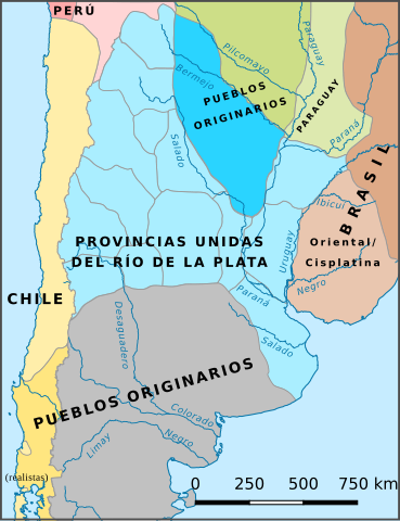
Español: Provincias Unidas del Río de la Plata en 1821 y territorios colindantes. |
| Date | |
| Source | Mapa ARGENTINA 1821.jpg |
| Author |
Mapa ARGENTINA 1821.jpg: pruxo
|
Licensing[edit]
This file is licensed under the Creative Commons Attribution-Share Alike 3.0 Unported license.
- You are free:
- to share – to copy, distribute and transmit the work
- to remix – to adapt the work
- Under the following conditions:
- attribution – You must give appropriate credit, provide a link to the license, and indicate if changes were made. You may do so in any reasonable manner, but not in any way that suggests the licensor endorses you or your use.
- share alike – If you remix, transform, or build upon the material, you must distribute your contributions under the same or compatible license as the original.
File history
Click on a date/time to view the file as it appeared at that time.
| Date/Time | Thumbnail | Dimensions | User | Comment | |
|---|---|---|---|---|---|
| current | 17:23, 4 March 2024 | | 1,266 × 1,645 (637 KB) | Janitoalevic (talk | contribs) | . |
| 03:12, 20 October 2023 |  | 1,266 × 1,645 (607 KB) | Janitoalevic (talk | contribs) | Arreglos | |
| 10:11, 17 February 2018 |  | 1,187 × 1,543 (838 KB) | Rowanwindwhistler (talk | contribs) | User created page with UploadWizard |
You cannot overwrite this file.
File usage on Commons
The following 3 pages use this file:
File usage on other wikis
The following other wikis use this file:
- Usage on ast.wikipedia.org
- Usage on bg.wikipedia.org
- Usage on de.wikipedia.org
- Usage on en.wikipedia.org
- Usage on es.wikipedia.org
- Usage on fr.wikipedia.org
- Usage on it.wikipedia.org
- Usage on lt.wikipedia.org
- Usage on ru.wikipedia.org
- Usage on sr.wikipedia.org
Metadata
Categories:
- Spanish-language SVG maps showing history of Argentina
- Maps of the United Provinces of the Río de la Plata
- SVG maps of the history of Uruguay
- Territorial evolution of Argentina
- SVG maps of the history of Argentina
- 1821 in Argentina
- 2018 maps of Argentina
- Spanish-language SVG maps showing history of Uruguay