File:Map of Russia - Economic regions, 2008-03-01.svg
Jump to navigation
Jump to search

Size of this PNG preview of this SVG file: 800 × 462 pixels. Other resolutions: 320 × 185 pixels | 640 × 369 pixels | 1,024 × 591 pixels | 1,280 × 738 pixels | 2,560 × 1,477 pixels | 1,092 × 630 pixels.
Original file (SVG file, nominally 1,092 × 630 pixels, file size: 220 KB)
Captions
Captions
Add a one-line explanation of what this file represents
| Description |
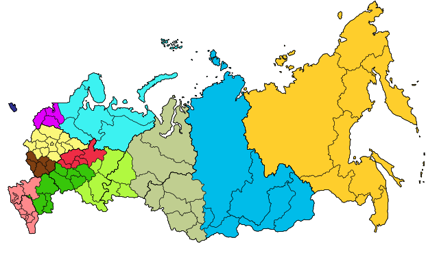
Map of the Economic regions of Russia with merged subjects (01.03.2008, last merger Chita Oblast+Agin-Buryat Autonomous Okrug to form Zabaykalsky Krai.) Central economic region
Central Black Earth economic region
East Siberian economic region
Far Eastern economic region
Northern economic region
North Caucasus economic region
Northwestern economic region
Volga economic region
Urals economic region
Volga-Vyatka economic region
West Siberian economic region
Kaliningrad economic region
Русский: экономи́ческие райо́ны |
| Date | |
| Source |
Based on Map of Russian subjects, 2008-03-01.svg by Lokal_Profil and info from en:Economic regions of Russia and colours from Economic regions of Russia.png by Nightstallion |
| Author | Lokal_Profil |
| Permission (Reusing this file) |
This file is licensed under the Creative Commons Attribution-Share Alike 2.5 Generic license. Attribution: Lokal_Profil
|
File history
Click on a date/time to view the file as it appeared at that time.
| Date/Time | Thumbnail | Dimensions | User | Comment | |
|---|---|---|---|---|---|
| current | 13:15, 8 March 2015 | | 1,092 × 630 (220 KB) | Knyaz-1988 (talk | contribs) | Новая версия |
| 23:27, 7 March 2015 |  | 1,092 × 630 (220 KB) | Knyaz-1988 (talk | contribs) | Новая версия | |
| 23:27, 7 March 2015 |  | 1,092 × 630 (257 KB) | Knyaz-1988 (talk | contribs) | Reverted to version as of 00:01, 4 November 2014 | |
| 22:53, 7 March 2015 |  | 1,092 × 630 (254 KB) | Knyaz-1988 (talk | contribs) | Новая версия | |
| 00:01, 4 November 2014 |  | 1,092 × 630 (257 KB) | Insider (talk | contribs) | Эта карта на точную дату (1 марта 2008). Пожалуйста загружите файл под другим именем. | |
| 23:49, 3 November 2014 |  | 1,092 × 630 (225 KB) | Knyaz-1988 (talk | contribs) | New version | |
| 23:48, 3 November 2014 |  | 1,092 × 630 (257 KB) | Knyaz-1988 (talk | contribs) | Reverted to version as of 18:05, 6 April 2008 | |
| 22:52, 3 November 2014 |  | 1,092 × 630 (225 KB) | Knyaz-1988 (talk | contribs) | New version | |
| 18:05, 6 April 2008 |  | 1,092 × 630 (257 KB) | Lokal Profil (talk | contribs) | {{Information |Description=Map of the Economic regions of Russia with merged subjects (01.03.2008, last merger Chita Oblast+Agin-Buryat Autonomous Okrug to form |
You cannot overwrite this file.
File usage on Commons
The following 4 pages use this file:
File usage on other wikis
The following other wikis use this file:
- Usage on af.wikipedia.org
- Usage on azb.wikipedia.org
- Usage on ca.wikipedia.org
- Usage on cs.wikipedia.org
- Usage on en.wikipedia.org
- Usage on es.wikipedia.org
- Usage on fa.wikipedia.org
- Usage on ga.wikipedia.org
- Usage on hu.wikipedia.org
- Usage on id.wikipedia.org
- Usage on it.wikipedia.org
- Usage on ja.wikipedia.org
- Usage on ko.wikipedia.org
- Usage on mk.wikipedia.org
- Usage on pt.wikipedia.org
- Usage on ro.wikipedia.org
- Usage on sah.wikipedia.org
- Usage on sh.wikipedia.org
- Usage on sk.wikipedia.org
- Usage on sl.wikipedia.org
- Usage on sv.wikipedia.org
- Usage on ta.wikipedia.org
- Usage on tl.wikipedia.org
- Usage on tr.wikipedia.org
- Usage on uk.wikipedia.org
- Usage on ur.wikipedia.org
- روس کے اقتصادی علاقہ جات
- مرکزی اقتصادی علاقہ
- مرکزی ارض اسود اقتصادی علاقہ
- مشرقی سائبیریائی اقتصادی علاقہ
- بعید مشرقی اقتصادی علاقہ
- سانچہ:روس کے اقتصادی علاقہ جات
- شمالی اقتصادی علاقہ (روس)
- شمالی قفقاز اقتصادی علاقہ
- شمال مغربی اقتصادی علاقہ
- وولگا اقتصادی علاقہ
- اورال اقتصادی علاقہ
- وولگا ویاتکا اقتصادی علاقہ
- مغربی سائبیریائی اقتصادی علاقہ