eritrea
The Eritrea Portal
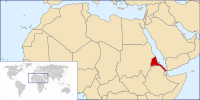
Eritrea (/ˌɛrɪˈtriːə/ ⓘ ERR-ih-TREE-ə or /-ˈtreɪ-/ -TRAY-; Tigrinya: ኤርትራ, romanized: Ertra, pronounced [ʔer(ɨ)trä] ⓘ), officially the State of Eritrea, is a country in the Horn of Africa region of Eastern Africa, with its capital and largest city at Asmara. It is bordered by Ethiopia in the south, Sudan in the west, and Djibouti in the southeast. The northeastern and eastern parts of Eritrea have an extensive coastline along the Red Sea. The nation has a total area of approximately 117,600 km2 (45,406 sq mi), and includes the Dahlak Archipelago and several of the Hanish Islands. Human remains found in Eritrea have been dated to 1 million years old and anthropological research indicates that the area may contain significant records related to the evolution of humans. The Kingdom of Aksum, covering much of modern-day Eritrea and northern Ethiopia, was established during the first or second century AD. It adopted Christianity around the middle of the fourth century. Beginning in the 12th century, the Ethiopian Zagwe and Solomonid dynasties held sway to a fluctuating extent over the entire plateau and the Red Sea coast. Eritrea's central highlands, known as Mereb Melash ("Beyond the Mereb"), were the northern frontier region of the Ethiopian kingdoms and were ruled by a governor titled the Bahr Negash ("lord of the sea"). In the 16th century, the Ottomans conquered the Eritrean coastline. Beginning in 1882–1885, Italian troops systematically spread out from Massawa toward the highland, eventually resulting in the formation of the colony of Italian Eritrea in 1889. After World War II, Eritrea was administered by the British Military Administration until 1952. Following the UN General Assembly decision in 1952, Eritrea would govern itself with a local Eritrean parliament, but for foreign affairs and defense, it would enter into a federal status with Ethiopia for ten years. However, in 1962, the government of Ethiopia annulled the Eritrean parliament and formally annexed Eritrea. The Eritrean secessionist movement organised the Eritrean Liberation Front in 1961 and fought the Eritrean War of Independence until Eritrea gained de facto independence in 1991. Eritrea gained de jure independence in 1993 after an independence referendum. Eritrea is one of the least developed countries. It is a unitary one-party presidential republic in which national legislative and presidential elections have never been held. Isaias Afwerki has served as president since its official independence in 1993. According to Human Rights Watch, the Eritrean government's human rights record is among the worst in the world. The Eritrean government has dismissed these allegations as politically motivated. Freedom of the press in Eritrea is extremely limited; the Press Freedom Index consistently ranks it as one of the least free countries. As of 2022 Reporters Without Borders considers the country to be among those with the least press freedom. Eritrea is a member of the African Union, the United Nations, and the Intergovernmental Authority on Development, and is an observer state in the Arab League alongside Brazil and Venezuela. (Full article...) Selected article - The Afar Triangle (also called the Afar Depression) is a geological depression caused by the Afar Triple Junction, which is part of the Great Rift Valley in East Africa. The region has disclosed fossil specimens of the very earliest hominins; that is, the earliest of the human clade, and it is thought by some paleontologists to be the cradle of the evolution of humans. The Depression overlaps the borders of Eritrea, Djibouti and the entire Afar Region of Ethiopia; and it contains the lowest point in Africa, Lake Assal, Djibouti, at 155 m (509 ft) below sea level. The Awash River is the main waterflow into the region, but it runs dry during the annual dry season, and ends as a chain of saline lakes. The northern part of the Afar Depression is also known as the Danakil Depression. The lowlands are affected by heat, drought, and minimal air circulation, and contain the hottest places (year-round average temperatures) of anywhere on Earth. (Full article...)Selected picture -Did you know -
CategoriesRelated portalsWikiProjectsGeneral images - Topics in EritreaSelected panorama -Associated WikiThe following Wiki Foundation sister projects provide more on this subject: SourcesDiscover Wikipedia using portals | |||||
This article uses material from the Wikipedia English article Portal:Eritrea, which is released under the Creative Commons Attribution-ShareAlike 3.0 license ("CC BY-SA 3.0"); additional terms may apply (view authors). Content is available under CC BY-SA 4.0 unless otherwise noted. Images, videos and audio are available under their respective licenses.
®Wikipedia is a registered trademark of the Wiki Foundation, Inc. Wiki English (DUHOCTRUNGQUOC.VN) is an independent company and has no affiliation with Wiki Foundation.


