National Register Of Historic Places Listings In Greenup County, Kentucky
This is a list of the National Register of Historic Places listings in Greenup County, Kentucky.

This is intended to be a complete list of the properties and districts on the National Register of Historic Places in Greenup County, Kentucky, United States. The locations of National Register properties and districts for which the latitude and longitude coordinates are included below, may be seen in a map.
There are 20 properties and districts listed on the National Register in the county.
This National Park Service list is complete through NPS recent listings posted April 26, 2024.
Current listings
| Name on the Register | Image | Date listed | Location | City or town | Description | |
|---|---|---|---|---|---|---|
| 1 | Bennett's Mill Covered Bridge | 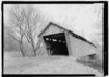 | March 26, 1976 (#76000892) | Kentucky Route 2125 west of Greenup 38°37′50″N 82°55′37″W / 38.630556°N 82.926944°W | Greenup | |
| 2 | Front Street District |  | January 27, 1988 (#87002448) | Front St. 38°34′39″N 82°50′03″W / 38.577500°N 82.834167°W | Greenup | |
| 3 | General U.S. Grant Bridge |  | May 31, 2001 (#01000560) | Ohio River-Chillicothe and 2nd St. 38°43′29″N 82°59′53″W / 38.724722°N 82.998056°W | South Portsmouth | Extends into Scioto County, Ohio. Demolished in 2001. |
| 4 | Greenup Masonic Lodge |  | January 27, 1988 (#87002447) | 314 Main St. 38°34′40″N 82°50′12″W / 38.577778°N 82.836667°W | Greenup | |
| 5 | Kouns-Hoffman House |  | January 27, 1988 (#87002445) | 208 Jefferson St. 38°34′37″N 82°50′00″W / 38.576806°N 82.833333°W | Greenup | |
| 6 | KY 2541 Bridge |  | January 27, 1988 (#87002446) | Main St. over the Little Sandy River 38°34′50″N 82°50′25″W / 38.580556°N 82.840278°W | Greenup | |
| 7 | Lower Shawneetown |  | April 28, 1983 (#83002784) | Northwest of Kentucky Route 8 38°42′54″N 83°01′42″W / 38.715000°N 83.028333°W | South Portsmouth | |
| 8 | Lower Shawneetown Archeological District |  | November 29, 1985 (#85003334) | Scattered around South Portsmouth 38°42′58″N 83°01′21″W / 38.716111°N 83.022500°W | South Portsmouth | Includes Lower Shawneetown and Group A of the Portsmouth Earthworks, and extends into Lewis County |
| 9 | McConnell House, Law Office, and Slave Quarters |  | July 30, 1975 (#75000764) | West of Wurtland on U.S. Route 23 38°33′07″N 82°47′19″W / 38.551944°N 82.788611°W | Wurtland | |
| 10 | McKee House |  | January 27, 1988 (#87002439) | 1023 Riverside Dr. 38°34′28″N 82°49′47″W / 38.574444°N 82.829861°W | Greenup | |
| 11 | Methodist Episcopal Church South |  | January 27, 1988 (#87002444) | Main St. 38°34′36″N 82°50′05″W / 38.576667°N 82.834722°W | Greenup | |
| 12 | Oldtown Covered Bridge |  | March 26, 1976 (#76000893) | South of Oldtown off Kentucky Route 1 38°25′53″N 82°53′42″W / 38.431389°N 82.895°W | Oldtown | |
| 13 | Portsmouth Earthworks, Group A |  | December 4, 1980 (#80001534) | Between County Route 8 and the Ohio River, west of South Portsmouth 38°43′18″N 83°01′23″W / 38.7216°N 83.023°W | South Portsmouth | |
| 14 | Russell Railroad YMCA |  | May 2, 2001 (#01000452) | 451 Verhon St. 38°32′02″N 82°41′52″W / 38.533889°N 82.697778°W | Russell | |
| 15 | South Greenup District |  | January 27, 1988 (#87002443) | Roughly bounded by the C&O railroad line, Laurel St., Seaton Ave., and Washington St. 38°34′37″N 82°50′19″W / 38.576944°N 82.838611°W | Greenup | |
| 16 | Jesse Stuart House |  | June 1, 1982 (#82002700) | Stuarts Lane off W. Hollow Rd. 38°33′02″N 82°50′13″W / 38.550556°N 82.836944°W | Greenup | |
| 17 | Warnock House |  | January 27, 1988 (#87002442) | 404 Harrison 38°34′38″N 82°50′14″W / 38.577222°N 82.837361°W | Greenup | |
| 18 | West Main Street District |  | January 27, 1988 (#87002441) | W. Main St. 38°34′44″N 82°50′18″W / 38.578889°N 82.838333°W | Greenup | |
| 19 | Worthington House |  | January 27, 1988 (#87002438) | U.S. Route 23 at Academy Rd. 38°34′06″N 82°49′56″W / 38.568333°N 82.832222°W | Greenup | |
| 20 | Wurtland Union Church |  | December 4, 2008 (#08001119) | 325 Wurtland Ave. 38°33′02″N 82°46′52″W / 38.550556°N 82.781111°W | Wurtland |
See also
References
This article uses material from the Wikipedia English article National Register of Historic Places listings in Greenup County, Kentucky, which is released under the Creative Commons Attribution-ShareAlike 3.0 license ("CC BY-SA 3.0"); additional terms may apply (view authors). Content is available under CC BY-SA 4.0 unless otherwise noted. Images, videos and audio are available under their respective licenses.
®Wikipedia is a registered trademark of the Wiki Foundation, Inc. Wiki English (DUHOCTRUNGQUOC.VN) is an independent company and has no affiliation with Wiki Foundation.