File:WenceslausIImap-en.png
Jump to navigation
Jump to search

Size of this preview: 590 × 599 pixels. Other resolutions: 236 × 240 pixels | 472 × 480 pixels | 756 × 768 pixels | 1,062 × 1,079 pixels.
Original file (1,062 × 1,079 pixels, file size: 296 KB, MIME type: image/png)
Captions
Captions
Add a one-line explanation of what this file represents
English[edit]
Kingdom of Bohemia
Kingdom of Poland
Probable extent of territory under control
of Wenceslaus II in Hungary
of Wenceslaus II in Hungary
Vassals
| Description |
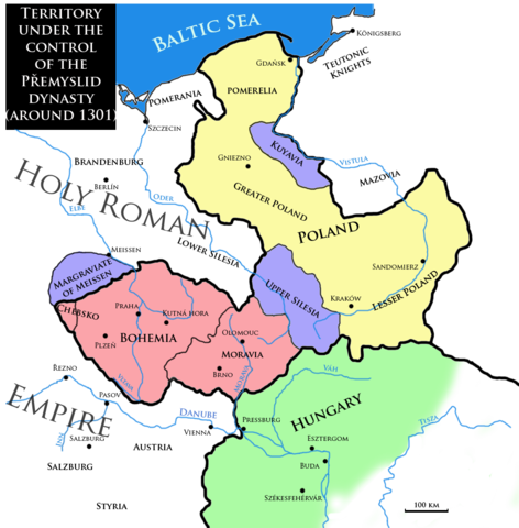
English: Territory under the control of the Přemyslid dynasty around year 1301. |
| Date | (UTC) |
| Source | |
| Author |
|
| Other versions | File:WenceslausIImap-blank.png, blank version for possible translation |
| This is a retouched picture, which means that it has been digitally altered from its original version. Modifications: translation to English. The original can be viewed here: WenceslausIImap-cs.png:
|
I, the copyright holder of this work, hereby publish it under the following licenses:
This file is licensed under the Creative Commons Attribution-Share Alike 3.0 Unported, 2.5 Generic, 2.0 Generic and 1.0 Generic license.
- You are free:
- to share – to copy, distribute and transmit the work
- to remix – to adapt the work
- Under the following conditions:
- attribution – You must give appropriate credit, provide a link to the license, and indicate if changes were made. You may do so in any reasonable manner, but not in any way that suggests the licensor endorses you or your use.
- share alike – If you remix, transform, or build upon the material, you must distribute your contributions under the same or compatible license as the original.

|
Permission is granted to copy, distribute and/or modify this document under the terms of the GNU Free Documentation License, Version 1.2 or any later version published by the Free Software Foundation; with no Invariant Sections, no Front-Cover Texts, and no Back-Cover Texts. A copy of the license is included in the section entitled GNU Free Documentation License. |
You may select the license of your choice.
Original upload log[edit]
This image is a derivative work of the following images:
- File:WenceslausIImap-cs.png licensed with Cc-by-sa-3.0,2.5,2.0,1.0, GFDL
- 2010-04-17T18:15:12Z Mozzan 1062x1079 (350428 Bytes) Added names of Tisza and Inn rivers; added scale
- 2010-04-17T14:51:45Z Mozzan 1062x1079 (346904 Bytes) {{Information |Description={{en|1=Territory under control of Přemyslid dynasty around year 1301. In Czech language.}} {{cs|1=Území ovládané přemyslovskou dynastií kolem roku 1301.}} |Source={{own}} zualoženo na / bas
Uploaded with derivativeFX
File history
Click on a date/time to view the file as it appeared at that time.
| Date/Time | Thumbnail | Dimensions | User | Comment | |
|---|---|---|---|---|---|
| current | 23:55, 20 November 2013 | | 1,062 × 1,079 (296 KB) | EDCBA (talk | contribs) | Fixing mistake with "'Zachodnio-pomorskie' what is Pomerania. Region described in previous version is called Pomerelia or 'Gdańsk Pomerania'. More information can be found in article: Eastern Pomerania |
| 22:25, 19 July 2011 |  | 1,062 × 1,079 (343 KB) | Mozzan (talk | contribs) | {{Information |Description={{en|1=Territory under the control of the Přemyslid dynasty around year 1301.}} |Source=*File:WenceslausIImap-cs.png |Date=2011-07-19 22:21 (UTC) |Author=*File:WenceslausIImap-cs.png: Mozzan *derivat |
You cannot overwrite this file.
File usage on Commons
There are no pages that use this file.
File usage on other wikis
The following other wikis use this file:
- Usage on ar.wikipedia.org
- Usage on azb.wikipedia.org
- Usage on ba.wikipedia.org
- Usage on be.wikipedia.org
- Usage on bn.wikipedia.org
- Usage on ca.wikipedia.org
- Usage on csb.wikipedia.org
- Usage on cs.wikipedia.org
- Usage on da.wikipedia.org
- Usage on de.wikipedia.org
- Usage on de.wikibooks.org
- Usage on en.wikipedia.org
- Usage on es.wikipedia.org
- Usage on fr.wikipedia.org
- Usage on hu.wikipedia.org
- Usage on id.wikipedia.org
- Usage on it.wikipedia.org
- Usage on ja.wikipedia.org
- Usage on ka.wikipedia.org
- Usage on lt.wikipedia.org
- Usage on lv.wikipedia.org
- Usage on nl.wikipedia.org
- Usage on pt.wikipedia.org
- Usage on ro.wikipedia.org
- Usage on ru.wikipedia.org
- Usage on sl.wikipedia.org
- Usage on vi.wikipedia.org