File:Percent Population change by state from 2010 - 2020.svg
Jump to navigation
Jump to search

Size of this PNG preview of this SVG file: 800 × 474 pixels. Other resolutions: 320 × 190 pixels | 640 × 380 pixels | 1,024 × 607 pixels | 1,280 × 759 pixels | 2,560 × 1,518 pixels | 1,000 × 593 pixels.
Original file (SVG file, nominally 1,000 × 593 pixels, file size: 75 KB)
Captions
Captions
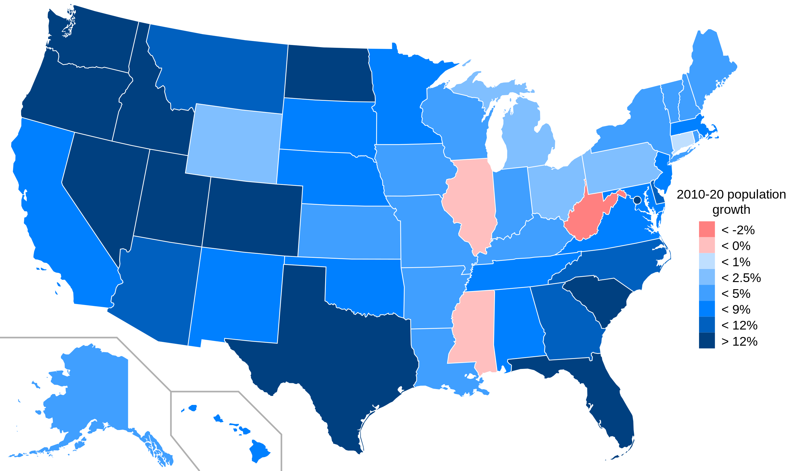
States in the US shown with population change 2010 to 2020 census
Summary[edit]
| Description |
English: States in the US shown with population change 2010 to 2020 census
-2.00% or less
-0.01% to -1.99%
0% to 0.99%
1% to 2.49%
2.5% to 4.99%
5% to 8.99%
9% to 11.99%
12% or more |
| Date | |
| Source | Own work - File:Blank US Map (states only).svg - data from here |
| Author | Oogle12 |
.svg)
Licensing[edit]
I, the copyright holder of this work, hereby publish it under the following license:
This file is licensed under the Creative Commons Attribution-Share Alike 4.0 International license.
- You are free:
- to share – to copy, distribute and transmit the work
- to remix – to adapt the work
- Under the following conditions:
- attribution – You must give appropriate credit, provide a link to the license, and indicate if changes were made. You may do so in any reasonable manner, but not in any way that suggests the licensor endorses you or your use.
- share alike – If you remix, transform, or build upon the material, you must distribute your contributions under the same or compatible license as the original.
File history
Click on a date/time to view the file as it appeared at that time.
| Date/Time | Thumbnail | Dimensions | User | Comment | |
|---|---|---|---|---|---|
| current | 01:08, 24 February 2022 | | 1,000 × 593 (75 KB) | Crossover1370 (talk | contribs) | remove % sign at top of legend, not necessary since all entries in legend contain % signs |
| 01:01, 24 February 2022 |  | 1,000 × 593 (75 KB) | Crossover1370 (talk | contribs) | Change to red-blue color scale. Since #ff0000 is similar in appearance to #ff6600, it was hard to tell whether a state declined slightly or grew slightly. Also, blue is better for red-green colorblind people. | |
| 20:56, 3 July 2021 |  | 959 × 593 (68 KB) | Oogle12 (talk | contribs) | Uploaded own work with UploadWizard |
You cannot overwrite this file.
File usage on Commons
There are no pages that use this file.
File usage on other wikis
The following other wikis use this file:
- Usage on en.wikipedia.org
- Usage on ru.wikipedia.org
- Usage on simple.wikipedia.org
- Usage on uz.wikipedia.org