File:Map of Ukraine with Cities.png
Jump to navigation
Jump to search
Size of this preview: 800 × 538 pixels. Other resolutions: 320 × 215 pixels | 640 × 430 pixels | 1,024 × 688 pixels | 1,280 × 860 pixels | 2,560 × 1,720 pixels | 4,844 × 3,255 pixels.
Original file (4,844 × 3,255 pixels, file size: 2.72 MB, MIME type: image/png)
Captions
Captions
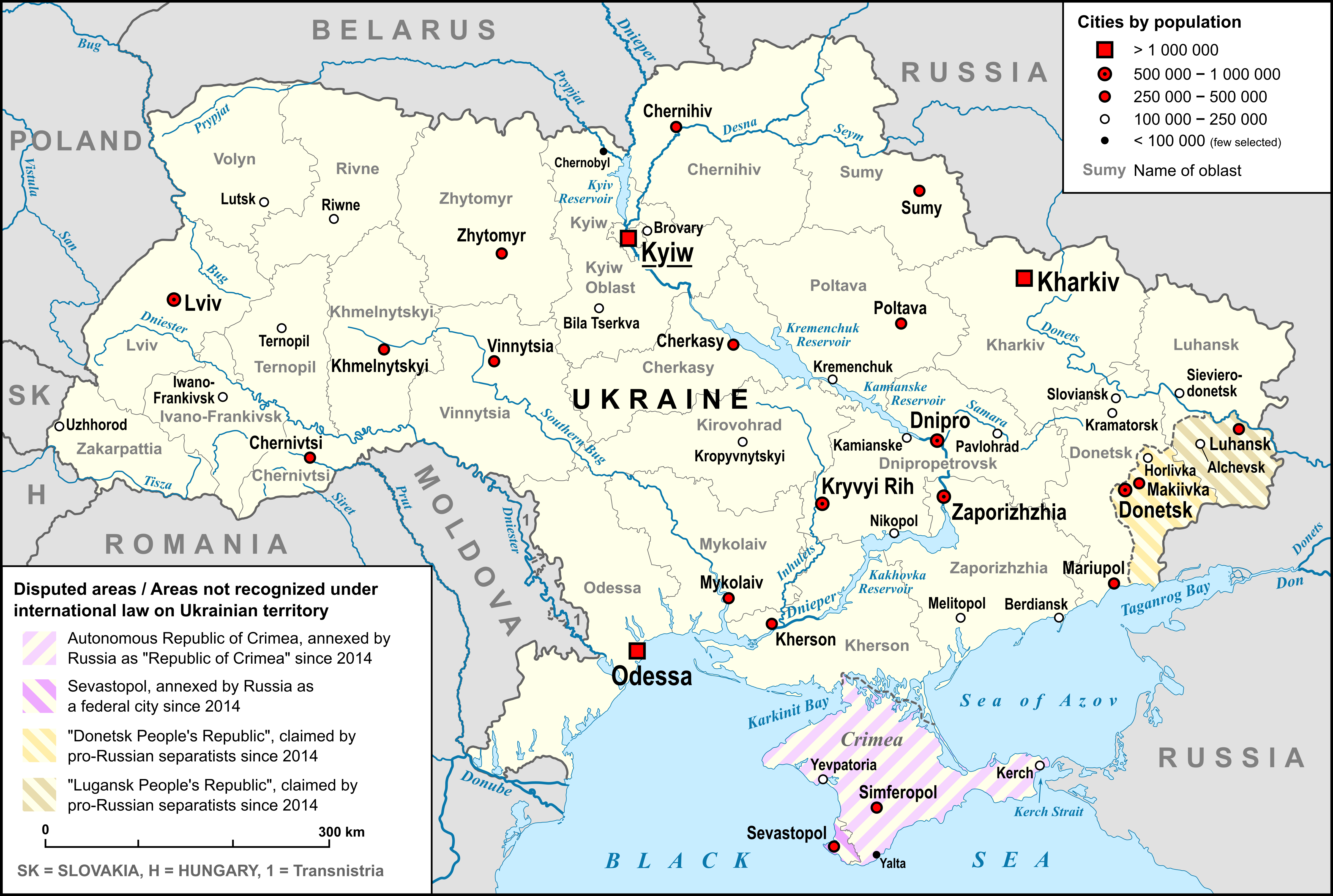
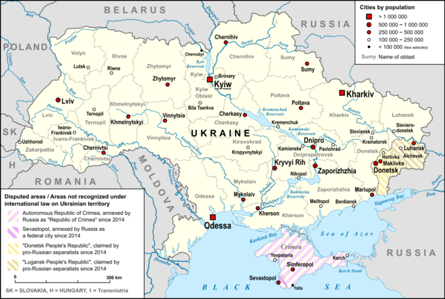
Map of Ukraine
Summary[edit]
| Description |
English: Map of Ukraine, with Oblasts, largest cities, rivers and neighboring countries, as well as the disputed areas on the territory of Ukraine, "Republic of Crimea", "Luhansk People's Republic" and "Donetsk People's Republic" |
| Date | |
| Source |
own work, used: |
| Author | Lencer |
| Other versions |
 |

|
This map has been made or improved in the German Kartenwerkstatt (Map Lab). You can propose maps to improve as well.
|
Licensing[edit]
I, the copyright holder of this work, hereby publish it under the following license:
This file is licensed under the Creative Commons Attribution-Share Alike 3.0 Unported license.
- You are free:
- to share – to copy, distribute and transmit the work
- to remix – to adapt the work
- Under the following conditions:
- attribution – You must give appropriate credit, provide a link to the license, and indicate if changes were made. You may do so in any reasonable manner, but not in any way that suggests the licensor endorses you or your use.
- share alike – If you remix, transform, or build upon the material, you must distribute your contributions under the same or compatible license as the original.
File history
Click on a date/time to view the file as it appeared at that time.
| Date/Time | Thumbnail | Dimensions | User | Comment | |
|---|---|---|---|---|---|
| current | 12:34, 9 March 2022 | | 4,844 × 3,255 (2.72 MB) | Lencer (talk | contribs) | corr specification |
| 11:27, 6 March 2022 |  | 4,844 × 3,255 (2.71 MB) | Lencer (talk | contribs) | + hatching | |
| 20:17, 3 March 2022 |  | 4,844 × 3,255 (2.67 MB) | Lencer (talk | contribs) | == {{int:filedesc}} == {{Information |Description= {{en|Map of Ukraine, with Oblasts, largest cities, rivers and neighboring countries, as well as the disputed areas on the territory of Ukraine, "Republic of Crimea", "Luhansk People's Republic" and "Donetsk People's Republic"}} |Source=own work, used: * Ukraine_adm_location_map.svg by User:NordNordWest * Ukraine_2022-02-21.svg by User:NordNordWest... |
You cannot overwrite this file.
File usage on Commons
The following 2 pages use this file:
File usage on other wikis
The following other wikis use this file:
- Usage on de.wikipedia.org
- Usage on en.wikipedia.org
- Usage on fi.wikipedia.org
- Usage on fr.wikipedia.org
- Usage on hy.wikipedia.org
- Usage on id.wikipedia.org
- Usage on ja.wikipedia.org
- Usage on ka.wikipedia.org
- Usage on kk.wikipedia.org
- Usage on km.wikipedia.org
- Usage on ko.wikipedia.org
- Usage on ku.wikipedia.org
- Usage on simple.wikipedia.org
- Usage on sk.wikipedia.org
- Usage on sl.wikipedia.org
- Usage on ta.wikipedia.org
- Usage on tg.wikipedia.org
- Usage on th.wikipedia.org
- Usage on tr.wikipedia.org
- Usage on uk.wikipedia.org
- Usage on vi.wikipedia.org
- Usage on vls.wikipedia.org
- Usage on zh.wikipedia.org