File:Map of Great Hanshin Awaji Earthquake Ja.svg
Jump to navigation
Jump to search

Size of this PNG preview of this SVG file: 377 × 599 pixels. Other resolutions: 151 × 240 pixels | 302 × 480 pixels | 483 × 768 pixels | 644 × 1,024 pixels | 1,289 × 2,048 pixels | 530 × 842 pixels.
Original file (SVG file, nominally 530 × 842 pixels, file size: 38 KB)
Captions
Captions
Add a one-line explanation of what this file represents
Summary[edit]
| Description |
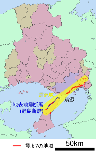
English: Map of Great Hanshin earthquake.
日本語: 兵庫県南部地震(阪神・淡路大震災)の地図。震度7の地域(震災の帯)、震源(震央)、震源域、野島断層の位置などを説明。 |
| Date | |
| Source | Map:File:Map_of_Hyogo_Prefecture_Ja.svg, epicenter map:google map, epicenter and shindo:JMA, epicenter area:CCEP Japan, Nojima Fault:kobe-c.ed.jp |
| Author | own work |
Licensing[edit]

|
Permission is granted to copy, distribute and/or modify this document under the terms of the GNU Free Documentation License, Version 1.2 or any later version published by the Free Software Foundation; with no Invariant Sections, no Front-Cover Texts, and no Back-Cover Texts. A copy of the license is included in the section entitled GNU Free Documentation License. |
| This file is licensed under the Creative Commons Attribution-Share Alike 3.0 Unported license. | ||
| ||
| This licensing tag was added to this file as part of the GFDL licensing update. |
File history
Click on a date/time to view the file as it appeared at that time.
| Date/Time | Thumbnail | Dimensions | User | Comment | |
|---|---|---|---|---|---|
| current | 05:40, 18 January 2009 | | 530 × 842 (38 KB) | Pekachu (talk | contribs) | {{Information |Description= |Source= |Date= |Author= |Permission= |other_versions= }} |
| 11:08, 17 January 2009 |  | 530 × 842 (36 KB) | Pekachu (talk | contribs) | {{Information |Description={{en|1=Map of Great Hanshin earthquake.}} {{ja|1=兵庫県南部地震(阪神・淡路大震災)の地図。震度7の地域(震災の帯)、震源(震央� |
You cannot overwrite this file.
File usage on Commons
The following 2 pages use this file:
File usage on other wikis
The following other wikis use this file:
- Usage on ast.wikipedia.org
- Usage on en.wikipedia.org
- Usage on es.wikipedia.org
- Usage on it.wikipedia.org
- Usage on ja.wikipedia.org
- Usage on ko.wikipedia.org
- Usage on sl.wikipedia.org
- Usage on th.wikipedia.org
- Usage on www.wikidata.org
- Usage on zh.wikipedia.org