File:Kherson military–civilian administration hatched.svg
Jump to navigation
Jump to search

Size of this PNG preview of this SVG file: 800 × 586 pixels. Other resolutions: 320 × 235 pixels | 640 × 469 pixels | 1,024 × 750 pixels | 1,280 × 938 pixels | 2,560 × 1,876 pixels | 1,430 × 1,048 pixels.
Original file (SVG file, nominally 1,430 × 1,048 pixels, file size: 140 KB)
Captions
Captions
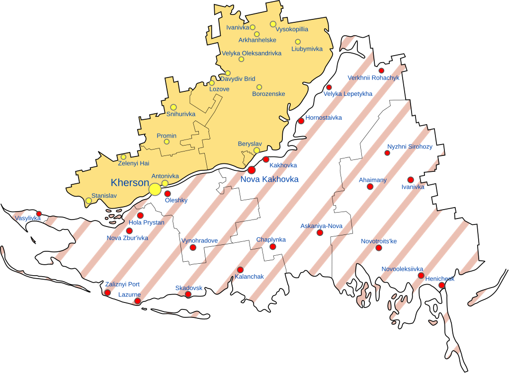
Map of the Kherson Military–Civilian Administration
Summary[edit]
| Description |
English: Map of Russia's Khersonskaya Oblast, made up of the whole of Kherson Oblast & parts of Mykolaiv Oblast in Ukraine. |
| Date | |
| Source | Own work, based on Russian Occupation of Kherson Oblast.svg |
| Author | Physeters, hatching by Antimuonium |
| Other versions |
[]
|


.png)


.png)


Licensing[edit]
I, the copyright holder of this work, hereby publish it under the following license:
This file is licensed under the Creative Commons Attribution-Share Alike 4.0 International license.
- You are free:
- to share – to copy, distribute and transmit the work
- to remix – to adapt the work
- Under the following conditions:
- attribution – You must give appropriate credit, provide a link to the license, and indicate if changes were made. You may do so in any reasonable manner, but not in any way that suggests the licensor endorses you or your use.
- share alike – If you remix, transform, or build upon the material, you must distribute your contributions under the same or compatible license as the original.
File history
Click on a date/time to view the file as it appeared at that time.
| Date/Time | Thumbnail | Dimensions | User | Comment | |
|---|---|---|---|---|---|
| current | 07:00, 5 December 2022 | | 1,430 × 1,048 (140 KB) | Physeters (talk | contribs) | update |
| 05:32, 28 September 2022 |  | 1,430 × 1,048 (150 KB) | Antimuonium (talk | contribs) | Uploaded own work with UploadWizard |
You cannot overwrite this file.
File usage on Commons
The following 53 pages use this file:
- Ukraine Regional Occupation Maps
- User:Jcornelius/Angola/2022 December 1-10
- User:Jcornelius/Angola/2022 September 21-30
- User:Magog the Ogre/Maps of conflicts/2022 December
- User:Magog the Ogre/Maps of conflicts/2022 September
- User:ביקורת/Rabbis/2022 December 5
- File:Dnipropetrovsk-poltava oblast occupation.png
- File:Dnipropetrovsk Oblast border skirmishes.png
- File:Kharkiv Oblast Control Evolution.png
- File:Kherson military–civilian administration.png
- File:Kherson military–civilian administration hatched.svg
- File:Occupation of Mykolaiv Oblast by Russia (With Cities).png
- File:Poltava oblast border skirmishes.png
- File:Russian Occupation of Chernihiv Oblast.svg
- File:Russian Occupation of Crimea.svg
- File:Russian Occupation of Donetsk Oblast.svg
- File:Russian Occupation of Kharkiv Oblast.svg
- File:Russian Occupation of Kherson Oblast.svg
- File:Russian Occupation of Kyiv Oblast.png
- File:Russian Occupation of Kyiv Oblast.svg
- File:Russian Occupation of Mykolaiv Oblast.svg
- File:Russian Occupation of Sumy Oblast.svg
- File:Russian Occupation of Zaporizhzhia Oblast.svg
- File:Russian Occupation of Zhytomyr Oblast.svg
- File:Russian occupation of Chernihiv Oblast.png
- File:Russian occupation of Chernihiv Oblast peak.png
- File:Russian occupation of Donetsk Oblast.png
- File:Russian occupation of Kharkiv Oblast.png
- File:Russian occupation of Luhansk Oblast.png
- File:Russian occupation of Luhansk Oblast.svg
- File:Russian occupation of Mykolaiv Oblast.png
- File:Russian occupation of Sumy Oblast.png
- File:Russian occupation of Zhytomyr Oblast.png
- File:Zaporizhzhia frontline.png
- File:Zaporizhzhia military–civilian administration hatched.svg
- File:Zaporizhzhia region.png
- File:Днепропетровская область.png
- File:Донецкая область или Донецкая народная Республика.png
- File:Житомирская область.png
- File:Запорожская область.png
- File:Карта звільнених територій Житомирської області.png
- File:Киев.png
- File:Киевская область.png
- File:Крым (Автономная Республика).png
- File:Луганская область или Луганская Народная Республика.png
- File:Николаевская область 2.png
- File:Одесская область 2.png
- File:Полтавская область.png
- File:Севастополь.png
- File:Сумская область.png
- File:Харьковская область 2.png
- File:Херсонская область.png
- File:Черниговская область 2.png
File usage on other wikis
The following other wikis use this file:
- Usage on de.wikipedia.org
- Usage on en.wikipedia.org
- Usage on fr.wikipedia.org
- Usage on hu.wikipedia.org
- Usage on it.wikipedia.org
- Usage on ja.wikipedia.org
- Usage on pt.wikipedia.org