File:Kartskiss över Nya Sverige.png
Jump to navigation
Jump to search

Size of this preview: 418 × 599 pixels. Other resolutions: 167 × 240 pixels | 335 × 480 pixels | 771 × 1,105 pixels.
Original file (771 × 1,105 pixels, file size: 61 KB, MIME type: image/png)
Captions
Captions
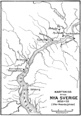
New Sweden map by Amandes Johnson

|
This historical map image could be re-created using vector graphics as an SVG file. This has several advantages; see Commons:Media for cleanup for more information. If an SVG form of this image is available, please upload it and afterwards replace this template with
{{vector version available|new image name}}.
It is recommended to name the SVG file “Kartskiss över Nya Sverige.svg”—then the template Vector version available (or Vva) does not need the new image name parameter. |
Summary[edit]
| Description |
Svenska: Kartskiss över Nya Sverige.png
العربية: خريطة السويد الجديدة بقلم اماندس جونسون
English: Map sketch of New Sweden.png |
||||||||
| Date | 13 June 2004 (original upload date) | ||||||||
| Source | Källa:Nordisk familjebok (1914), band 20, sida 153-154 [1] | ||||||||
| Author | |||||||||
| Permission (Reusing this file) |
|
||||||||
| Other versions |
|


Original upload log[edit]
(All user names refer to sv.wikipedia)
- 2004-06-13 05:53 Den fjättrade ankan 771×1105×8 (62007 bytes) från Nordisk familjebok
File history
Click on a date/time to view the file as it appeared at that time.
| Date/Time | Thumbnail | Dimensions | User | Comment | |
|---|---|---|---|---|---|
| current | 20:36, 26 December 2006 | | 771 × 1,105 (61 KB) | Nicke L (talk | contribs) | {{Information |Description= sv:Kategori:Kartor från Nordisk familjebok sv:Kategori:Sveriges historia |Source= *Källa:Nordisk familjebok (1914), band 20, sida 153-154 [http://runeberg.org/nfbt/0095.html] *Originally from [http://sv.wikipedia.or |
You cannot overwrite this file.
File usage on Commons
The following 5 pages use this file:
File usage on other wikis
The following other wikis use this file:
- Usage on af.wikipedia.org
- Usage on ar.wikipedia.org
- Usage on arz.wikipedia.org
- Usage on ast.wikipedia.org
- Usage on azb.wikipedia.org
- Usage on az.wikipedia.org
- Usage on be.wikipedia.org
- Usage on ca.wikipedia.org
- Usage on en.wikipedia.org
- Usage on eo.wikipedia.org
- Usage on es.wikipedia.org
- Usage on et.wikipedia.org
- Usage on eu.wikipedia.org
- Usage on fi.wikipedia.org
- Usage on fr.wikipedia.org
- Usage on he.wikipedia.org
- Usage on hy.wikipedia.org
- Usage on id.wikipedia.org
- Usage on it.wikipedia.org
- Usage on ja.wikipedia.org
View more global usage of this file.
Categories:
- Maps of New Sweden
- Swedish-language maps
- 1650s maps of Pennsylvania
- 1650s maps of Delaware
- Philadelphia in the 1650s
- 1650s maps of New Jersey
- Amandus Johnson
- Maps from Nordisk familjebok
- 1910s maps showing history
- Fort Nya Elfsborg
- Fort Nassau (South River)
- Upland, Pennsylvania
- Fort Christina
- Delaware River in the 17th century