File:Germany (2), Neuwerk, Scharhörn, Nigehörn.jpg
Jump to navigation
Jump to search
Size of this preview: 691 × 600 pixels. Other resolutions: 277 × 240 pixels | 553 × 480 pixels | 885 × 768 pixels | 1,180 × 1,024 pixels | 1,941 × 1,684 pixels.
Original file (1,941 × 1,684 pixels, file size: 550 KB, MIME type: image/jpeg)
Captions
Captions
Add a one-line explanation of what this file represents
Summary[edit]
,_Neuwerk,_Scharh%C3%B6rn,_Nigeh%C3%B6rn.jpg&action=edit§ion=1)
| Description |
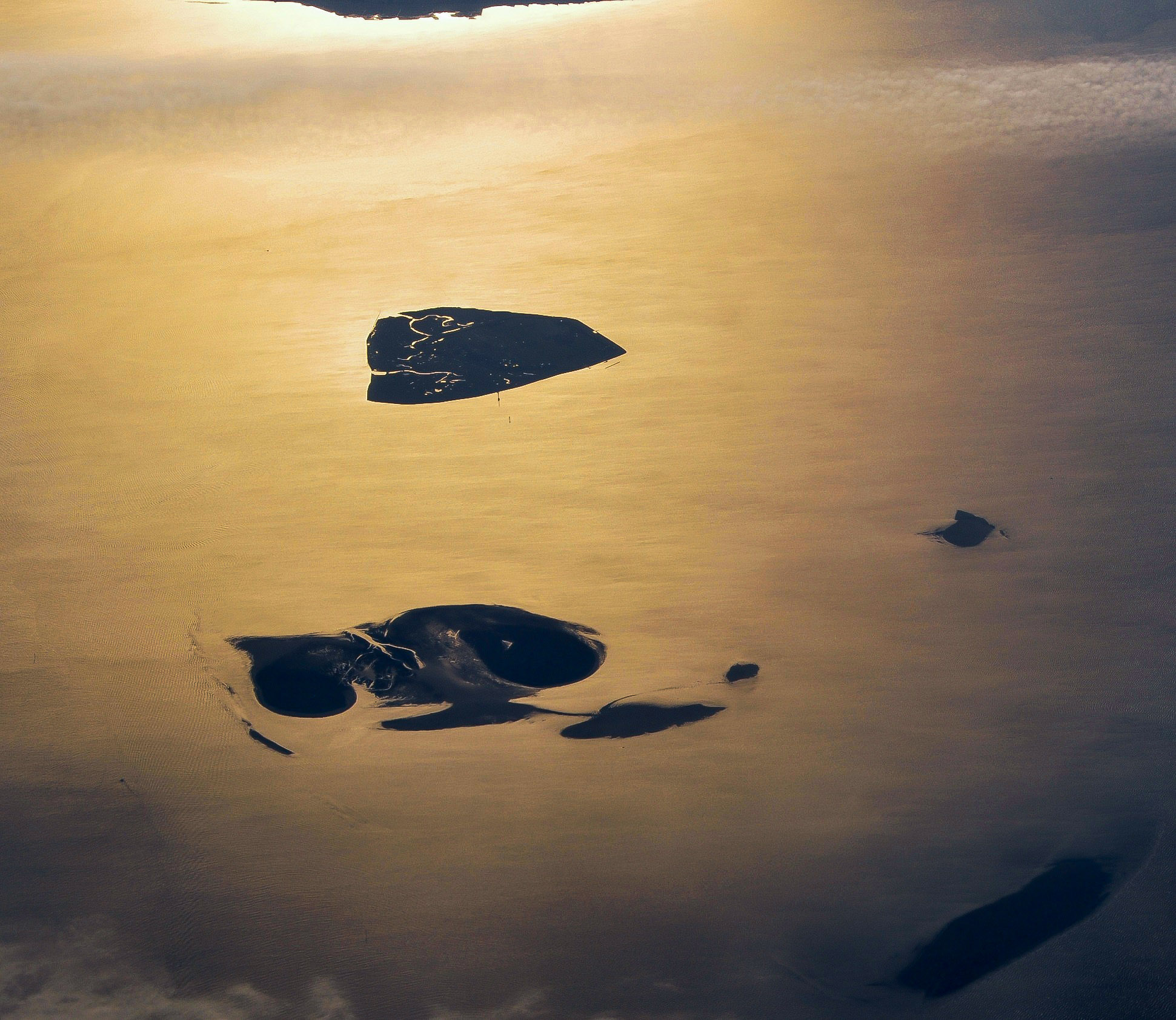
English: Aerial picture of the Hamburg Wadden Sea National Park (German: Nationalpark Hamburgisches Wattenmeer). This park is an exclave of the city state of Hamburg and lies 12.5 km off Cuxhaven in the estuary of the Elbe in the North Sea. The park includes the islands of Neuwerk (above), Scharhörn and Nigehörn (below, appearing as a single island in this picture taken at low tide). The two other islands (right and below right) are parts of the Scharhörn and Neuwerk mudflats (Scharhörner und Neuwerker Watt). Viewing direction is toward the SE.
Nederlands: Luchtfoto van het Hamburgse Nationale Park Waddenzee (Duits: Nationalpark Hamburgisches Wattenmeer). Dit park is een exclave van de stadstaat Hamburg en ligt 12.5 ten NW van Cuxhaven in de monding van de Elbe in de Noordzee. Het park omvat de eilanden Neuwerk (boven), Scharhörn en Nigehörn (die op de foto op één eiland lijken). De twee andere eilanden (rechts en rechts onder) zijn delen van het Scharhörnse en Neuwerkse Wad (Scharhörner und Neuwerker Watt). Blikrichting is naar het zuidoosten. |
| Date | |
| Source | Own work |
| Author | Vincent van Zeijst |
| Permission (Reusing this file) |
This file is licensed under the Creative Commons Attribution-Share Alike 3.0 Unported license.
|
| Camera location | | View this and other nearby images on: OpenStreetMap |
|---|
,_Neuwerk,_Scharh%C3%B6rn,_Nigeh%C3%B6rn.jpg¶ms=053.998083_N_0008.338622_E_globe:Earth_type:camera_region:DE_heading:135.00&language=en)
| Annotations | This image is annotated: View the annotations at Commons |
,_Neuwerk,_Scharh%C3%B6rn,_Nigeh%C3%B6rn.jpg)
File history
Click on a date/time to view the file as it appeared at that time.
| Date/Time | Thumbnail | Dimensions | User | Comment | |
|---|---|---|---|---|---|
| current | 13:59, 27 December 2017 | | 1,941 × 1,684 (550 KB) | Aeroid (talk | contribs) | dust removal |
| 16:59, 26 March 2011 |  | 1,941 × 1,684 (543 KB) | Loranchet (talk | contribs) | {{Information |Description ={{en|1=Aerial picture of the Hamburg Wadden Sea National Park (German: Nationalpark Hamburgisches Wattenmeer). This park is an exclave of the city state of Hamburg and lies 12.5 km off Cuxhaven in the estuary of the Elbe in |
You cannot overwrite this file.
File usage on Commons
The following page uses this file:
File usage on other wikis
The following other wikis use this file:
- Usage on az.wikipedia.org
- Usage on ban.wikipedia.org
- Usage on de.wikipedia.org
- Usage on en.wikipedia.org
- Usage on fa.wikipedia.org
- Usage on hsb.wikipedia.org
- Usage on mk.wikipedia.org
- Usage on nl.wikipedia.org
- Usage on pl.wikipedia.org
- Usage on sv.wikipedia.org
- Usage on tr.wikipedia.org
- Usage on ur.wikipedia.org
- Usage on vi.wikipedia.org
- Usage on zh.wikipedia.org
,_Neuwerk,_Scharhörn,_Nigehörn.jpg&oldid=529733504)