File:Fuller projection with largest countries.svg
Jump to navigation
Jump to search

Size of this PNG preview of this SVG file: 512 × 341 pixels. Other resolutions: 320 × 213 pixels | 640 × 426 pixels | 1,024 × 682 pixels | 1,280 × 853 pixels | 2,560 × 1,705 pixels.
Original file (SVG file, nominally 512 × 341 pixels, file size: 203 KB)
Captions
Captions
Maps
Summary[edit]
| Description |
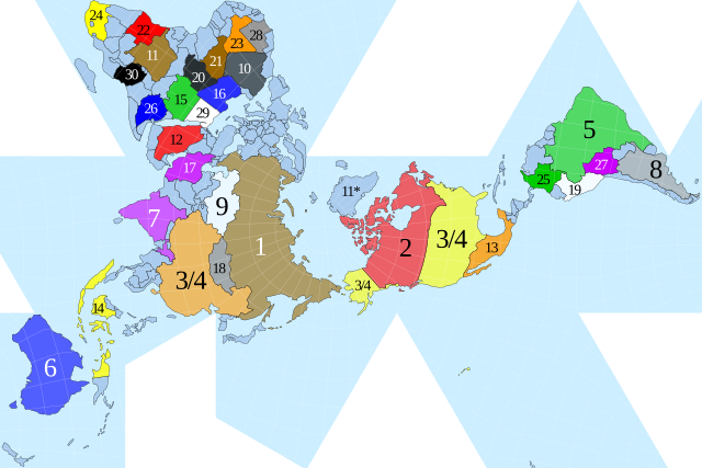
English: Dymaxion map of the world by visionscarto on http://visionscarto.net/public/fonds-de-cartes-en/visionscarto-airocean.svg with the 30 largest countries according to http://en.wikipedia.org/wiki/List_of_countries_and_dependencies_by_area#Graphical_charts roughly to scale highlighted by CMG Lee. |
|||
| Date | ||||
| Source |
|
|||
| Author | cmglee, Philippe Rivière | |||
| Other versions |
|


Licensing[edit]
This file is licensed under the Creative Commons Attribution-Share Alike 4.0 International license.
- You are free:
- to share – to copy, distribute and transmit the work
- to remix – to adapt the work
- Under the following conditions:
- attribution – You must give appropriate credit, provide a link to the license, and indicate if changes were made. You may do so in any reasonable manner, but not in any way that suggests the licensor endorses you or your use.
- share alike – If you remix, transform, or build upon the material, you must distribute your contributions under the same or compatible license as the original.
File history
Click on a date/time to view the file as it appeared at that time.
| Date/Time | Thumbnail | Dimensions | User | Comment | |
|---|---|---|---|---|---|
| current | 04:00, 6 November 2021 | | 512 × 341 (203 KB) | Md. Golam Mukit Khan (talk | contribs) | File uploaded using svgtranslate tool (https://svgtranslate.toolforge.org/). Added translation for bn. |
| 18:51, 26 July 2021 |  | 512 × 341 (197 KB) | Cmglee (talk | contribs) | Make text on grey backgrounds black // Editing SVG source code using c:User:Rillke/SVGedit.js | |
| 21:25, 15 February 2021 |  | 512 × 341 (197 KB) | Cmglee (talk | contribs) | Update as per http://en.wikipedia.org/wiki/Talk:List_of_countries_and_dependencies_by_area#Relative_size_and_location_map | |
| 02:41, 7 February 2021 |  | 512 × 288 (196 KB) | Cmglee (talk | contribs) | Uploaded a work by cmglee, Philippe Rivière from {{source thumb|Visionscarto-airocean.svg}} with UploadWizard |
You cannot overwrite this file.
File usage on Commons
The following 4 pages use this file:
File usage on other wikis
The following other wikis use this file:
- Usage on av.wikipedia.org
- Usage on bg.wikipedia.org
- Usage on bn.wikipedia.org
- Usage on ckb.wikipedia.org
- Usage on en.wikipedia.org
- Usage on hi.wikipedia.org
- Usage on id.wikipedia.org
- Usage on is.wikipedia.org
- Usage on ne.wikipedia.org
- Usage on ru.wikipedia.org
- Usage on th.wikipedia.org
- Usage on tr.wikipedia.org
- Usage on uz.wikipedia.org