File:Europe-blocs-49-89x4.svg
Jump to navigation
Jump to search

Size of this PNG preview of this SVG file: 800 × 501 pixels. Other resolutions: 320 × 201 pixels | 640 × 401 pixels | 1,024 × 642 pixels | 1,280 × 802 pixels | 2,560 × 1,605 pixels | 812 × 509 pixels.
Original file (SVG file, nominally 812 × 509 pixels, file size: 612 KB)
Captions
Captions
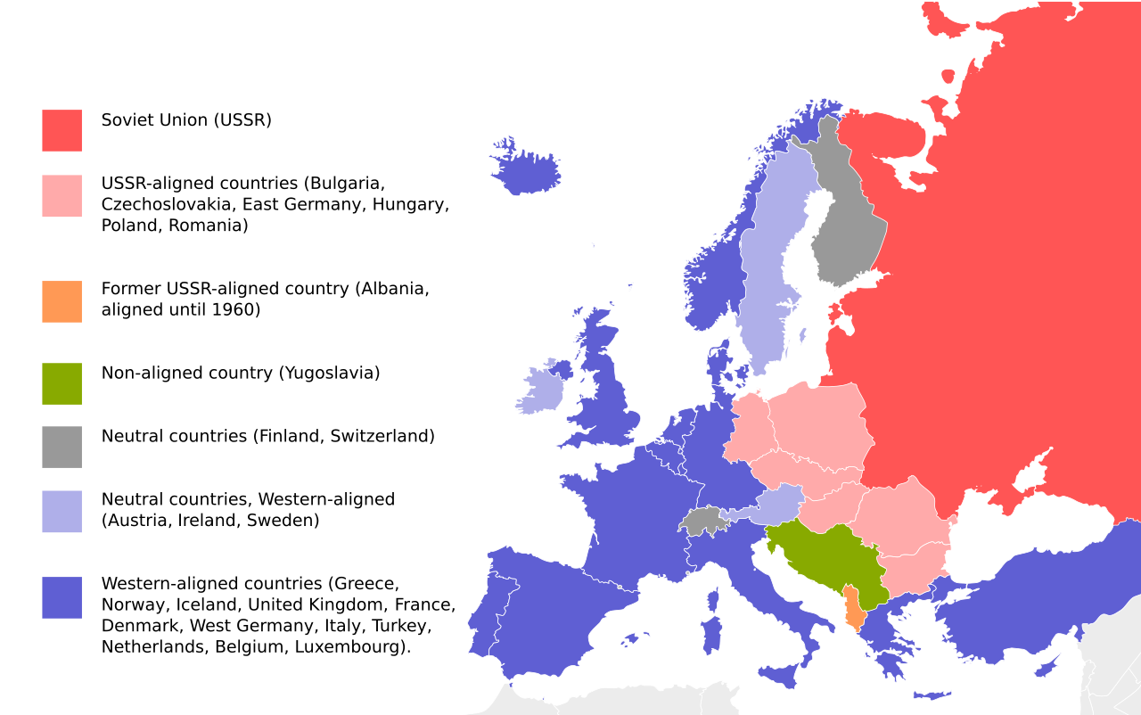
Eastern and Western Blocs in Cold War Europe
Summary[edit]
| Description |
English: Cold War map of Eastern and Western Blocs in Europe. Map based on File:EU27-further_enlargement_map.svg |
| Date | |
| Source | File:EU27-further_enlargement_map.svg |
| Author | UserGoldsztajn |
| Other versions |
[]
|


Licensing[edit]
| I, the copyright holder of this work, release this work into the public domain. This applies worldwide. In some countries this may not be legally possible; if so: I grant anyone the right to use this work for any purpose, without any conditions, unless such conditions are required by law. |
| Annotations | This image is annotated: View the annotations at Commons |
File history
Click on a date/time to view the file as it appeared at that time.
| Date/Time | Thumbnail | Dimensions | User | Comment | |
|---|---|---|---|---|---|
| current | 19:33, 2 October 2023 | | 812 × 509 (612 KB) | Gooduserdude (talk | contribs) | Reverted to version as of 22:37, 1 June 2019 (UTC) |
| 22:58, 18 September 2023 |  | 812 × 509 (238 KB) | Quetz72 (talk | contribs) | File uploaded using svgtranslate tool (https://svgtranslate.toolforge.org/). Added translation for ca. | |
| 04:10, 1 April 2022 |  | 812 × 509 (237 KB) | Yle-radio 1 (talk | contribs) | * | |
| 22:37, 1 June 2019 |  | 812 × 509 (612 KB) | Pedro8790 (talk | contribs) | Reverted to version as of 18:19, 22 September 2018 (UTC) | |
| 17:46, 30 May 2019 |  | 800 × 501 (198 KB) | Koldo Biguri (talk | contribs) | Translated into Basque | |
| 18:19, 22 September 2018 |  | 812 × 509 (612 KB) | Nablicus (talk | contribs) | correction France | |
| 12:06, 13 July 2018 |  | 812 × 509 (694 KB) | Nablicus (talk | contribs) | France was not neutral | |
| 07:29, 2 April 2009 |  | 812 × 509 (694 KB) | Goldsztajn (talk | contribs) | reedit | |
| 07:09, 2 April 2009 |  | 812 × 509 (694 KB) | Goldsztajn (talk | contribs) | reedit | |
| 06:58, 2 April 2009 |  | 812 × 509 (671 KB) | Goldsztajn (talk | contribs) | reedit |
You cannot overwrite this file.
File usage on Commons
The following 10 pages use this file:
- File:Blokoj en Eŭropo 1949-1989.svg
- File:Europe-blocs-49-89x4-ar.svg
- File:Europe-blocs-49-89x4-eu.svg
- File:Europe-blocs-49-89x4-fixed.svg
- File:Europe-blocs-49-89x4.svg
- File:Europe-blocs-49-89x4 RU.svg
- File:Europe-blocs-49-89x4 hu.svg
- File:Europe-blocs-49-89x4 mk.svg
- File:Europe-blocs-49-89x4 ua.svg
- Template:Other versions/Europe-blocs-49-89x4
File usage on other wikis
The following other wikis use this file:
- Usage on ar.wikipedia.org
- Usage on az.wikipedia.org
- Usage on bn.wikipedia.org
- Usage on ca.wikipedia.org
- Usage on cs.wikipedia.org
- Usage on da.wikipedia.org
- Usage on de.wikipedia.org
- Usage on de.wiktionary.org
- Usage on el.wikipedia.org
- Usage on en.wikipedia.org
- Western Europe
- Eastern Bloc
- Western Bloc
- Contemporary history
- Foreign policy of Vladimir Putin
- Talk:Eastern Bloc/Archive 1
- Wikipedia:Graphics Lab/Image workshop/Archive/Jun 2009
- Talk:Eastern Bloc/Archive 2
- Portal:Modern history
- User:Falcaorib
- Cyprus–Yugoslavia relations
- Malta–Yugoslavia relations
- User:Al83tito/sandbox4
- Usage on en.wikibooks.org
- Usage on en.wikivoyage.org
- Usage on en.wiktionary.org
- Usage on es.wikipedia.org
- Usage on es.wikivoyage.org
- Usage on ext.wikipedia.org
- Usage on fa.wikipedia.org
- Usage on he.wikipedia.org
- Usage on hr.wikipedia.org
- Usage on hy.wikipedia.org
- Usage on is.wikipedia.org
- Usage on ja.wikipedia.org
- Usage on ko.wikipedia.org
- Usage on li.wikipedia.org
- Usage on ml.wikipedia.org
- Usage on no.wikipedia.org
- Usage on pl.wikipedia.org
- Usage on pt.wikipedia.org
View more global usage of this file.