File:ElectoralCollege2020.svg
Jump to navigation
Jump to search

Size of this PNG preview of this SVG file: 800 × 465 pixels. Other resolutions: 320 × 186 pixels | 640 × 372 pixels | 1,024 × 595 pixels | 1,280 × 744 pixels | 2,560 × 1,488 pixels | 1,020 × 593 pixels.
Original file (SVG file, nominally 1,020 × 593 pixels, file size: 29 KB)
Captions
Captions
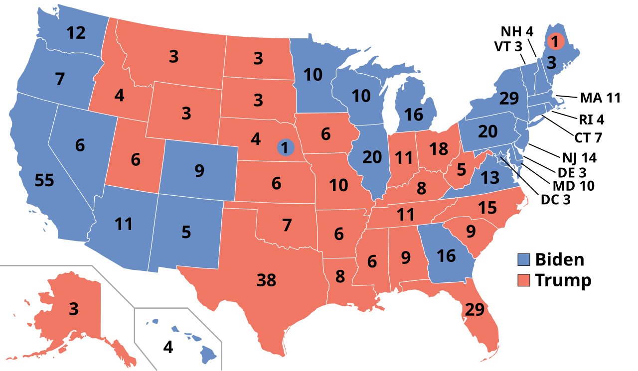
Map of the Presidential Election of 2020 between Joe Biden and Donald Trump
Summary[edit]
| Description |
English: Map of the Electoral College for the United States presidential election, 2020. |
||||
| Date | |||||
| Source | File:Electoral College 2016.svg | ||||
| Author | Kingofthedead | ||||
| Permission (Reusing this file) |
|
||||
| Other versions |
|
||||
| SVG development |

File history
Click on a date/time to view the file as it appeared at that time.
| Date/Time | Thumbnail | Dimensions | User | Comment | |
|---|---|---|---|---|---|
| current | 17:37, 28 April 2021 | | 1,020 × 593 (29 KB) | Nojus R (talk | contribs) | Reverted to version as of 22:05, 27 April 2021 (UTC) the one with results was meant to be temporary while the results were still ongoing. We have all the results, making this file useless. Every other election map does not have "with results" in it |
| 10:22, 28 April 2021 |  | 1,020 × 593 (28 KB) | JuTa (talk | contribs) | the other one is available at File:ElectoralCollege2020 with results.svg | |
| 22:05, 27 April 2021 |  | 1,020 × 593 (29 KB) | Nojus R (talk | contribs) | It's been almost 6 months, it's time to update the correct file. It was split into two because the results were still ongoing. | |
| 02:23, 4 November 2020 |  | 1,020 × 593 (28 KB) | GorillaWarfare (talk | contribs) | see Talk:2020 United States presidential election -- results should not be added until 12h after polls close at minimum | |
| 01:48, 4 November 2020 |  | 1,020 × 593 (32 KB) | RaviC (talk | contribs) | All of these have been called unanimously by the AP, NYT, CNN and 538 | |
| 00:52, 4 November 2020 |  | 1,020 × 593 (28 KB) | Prcc27 (talk | contribs) | No consensus for how to update map. Please see talk on Wikipedia. | |
| 00:41, 4 November 2020 |  | 1,020 × 593 (32 KB) | RaviC (talk | contribs) | VA | |
| 00:32, 4 November 2020 |  | 1,020 × 593 (32 KB) | RaviC (talk | contribs) | WV | |
| 00:29, 4 November 2020 |  | 1,020 × 593 (32 KB) | RaviC (talk | contribs) | KY, VT confirmed | |
| 00:22, 4 November 2020 |  | 1,020 × 593 (28 KB) | RaviC (talk | contribs) | Reverted to version as of 21:29, 3 October 2020 (UTC) |
You cannot overwrite this file.
File usage on Commons
The following 16 pages use this file:
- United States presidential election maps
- User:Magog the Ogre/Political maps/2016 April 1-10
- User:Magog the Ogre/Political maps/2016 July 11-20
- User:Magog the Ogre/Political maps/2016 July 21-31
- User:Magog the Ogre/Political maps/2017 January 11-20
- User:Magog the Ogre/Political maps/2018 November 11-20
- User:Magog the Ogre/Political maps/2020 November 1-10
- User:Magog the Ogre/Political maps/2020 November 11-20
- User:Magog the Ogre/Political maps/2020 October 1-10
- User:Magog the Ogre/Political maps/2021 April 21-30
- User:Magog the Ogre/Political maps/2021 March 21-31
- File:ElectorScaledU.S.2012-2020.svg
- File:ElectoralCollege2020 with results.svg (file redirect)
- File:ElectoralCollege2020 with results.svg.png (file redirect)
- File:Electoral College 2020.svg (file redirect)
- Category:United States presidential election, 2020
File usage on other wikis
The following other wikis use this file:
- Usage on ar.wikipedia.org
- Usage on ast.wikipedia.org
- Usage on az.wikipedia.org
- Usage on be.wikipedia.org
- Usage on bg.wikipedia.org
- Usage on bh.wikipedia.org
- Usage on bn.wikipedia.org
- Usage on bs.wikipedia.org
- Usage on cdo.wikipedia.org
- Usage on ckb.wikipedia.org
- Usage on cs.wikipedia.org
- Usage on cy.wikipedia.org
- Usage on da.wikipedia.org
- Usage on de.wikipedia.org
- Usage on diq.wikipedia.org
- Usage on el.wikipedia.org
- Usage on eml.wikipedia.org
- Usage on en.wikipedia.org
- United States Electoral College
- Donald Trump
- Electoral vote changes between United States presidential elections
- List of United States presidential election results by state
- Wikipedia:WikiProject United States presidential elections
- Electoral history of Joe Biden
- United States presidential election
- User:Mandruss/sandbox
- User:Visigoethe/sandbox
- 2020 United States presidential election
- 2020 United States elections
- User:AdamFilinovich/sandbox
- Electoral history of Kamala Harris
- Presidency of Donald Trump
- User:Medibee/sandbox
- User:Metropolitan90/2020 Infobox
- Talk:2020 United States presidential election/Archive 1
- Template:2020 United States presidential election imagemap
- User:Adr998/sandbox
View more global usage of this file.