File:Doric Greek Dialects.png
Jump to navigation
Jump to search
Size of this preview: 800 × 399 pixels. Other resolutions: 320 × 160 pixels | 640 × 319 pixels | 1,024 × 511 pixels | 1,280 × 638 pixels | 2,087 × 1,041 pixels.
Original file (2,087 × 1,041 pixels, file size: 336 KB, MIME type: image/png)
Captions
Captions
Add a one-line explanation of what this file represents
Summary[edit]
| Description |
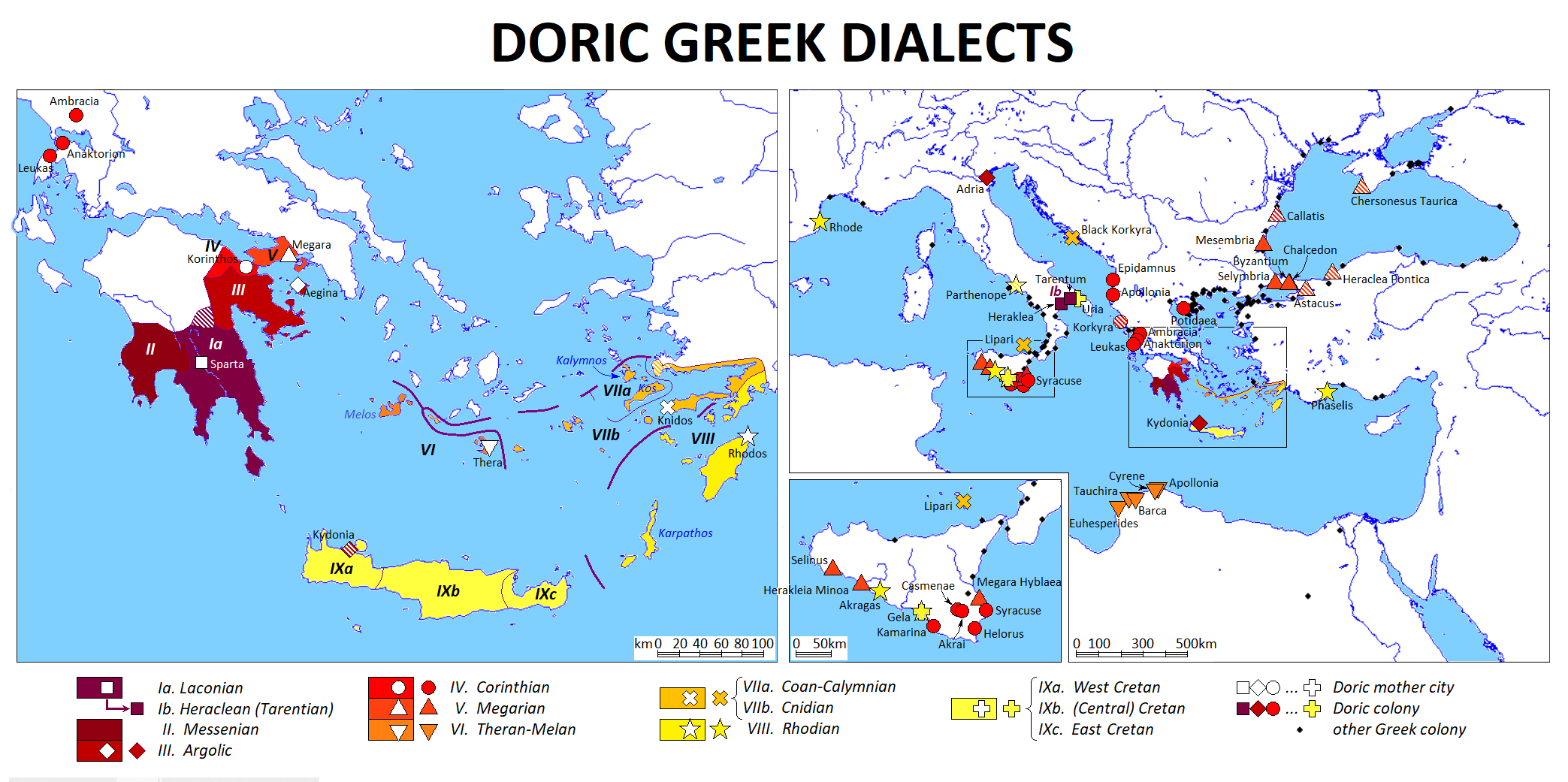
English: Geographic map of the Doric Greek dialects. Sources: Albert Thumb & E. Kieckers, Handbuch der griechischen Dialekte, 1. Teil, 2. erweiterte Auflage (Heidelberg 1932), pp. 69-226; Carl Darling Buck, Introduction to the Study of the Greek Dialects. Grammar, Selected inscriptions, Glossary, rev. ed. (1928) (https://archive.org/details/IntroductiontoGreekDialects/page/n11/mode/2up?view=theater); Greek dialect maps in historical atlases (Groszer Historischer Weltatlas herausgegeben vom Bayerischen Schulbuch-Verlag 1. Teil; Westermann Groszer Atlas zur Weltgeschichte); list of Greek colonies in: Tsetskhladze, Gocha R., Greek Colonisation. An account of Greek Colonies and Other Settlements Overseas. Vol. 1 (Brill, 2006) pp. lxvii - lxxiii (with addition: Heraklea, see Thumb p. 95). |
| Date | |
| Source | Own work |
| Author | Hans van Deukeren |
Licensing[edit]
I, the copyright holder of this work, hereby publish it under the following license:
This file is licensed under the Creative Commons Attribution-Share Alike 4.0 International license.
- You are free:
- to share – to copy, distribute and transmit the work
- to remix – to adapt the work
- Under the following conditions:
- attribution – You must give appropriate credit, provide a link to the license, and indicate if changes were made. You may do so in any reasonable manner, but not in any way that suggests the licensor endorses you or your use.
- share alike – If you remix, transform, or build upon the material, you must distribute your contributions under the same or compatible license as the original.
File history
Click on a date/time to view the file as it appeared at that time.
| Date/Time | Thumbnail | Dimensions | User | Comment | |
|---|---|---|---|---|---|
| current | 22:58, 4 January 2023 | | 2,087 × 1,041 (336 KB) | Hans van Deukeren (talk | contribs) | hatching of colonies with more than one mother city; Sicily map scale bar; arrow Ia→Ib (relation Laconian→Heraclean) |
| 15:21, 3 January 2023 |  | 2,087 × 1,041 (335 KB) | Hans van Deukeren (talk | contribs) | Phaselis colony of Rhodos; order of groups VII and VIII reversed; hatching of regions with mixed dialects (Tegea; Halikarnassos, Myndos) | |
| 23:49, 2 January 2023 |  | 2,087 × 1,041 (333 KB) | Hans van Deukeren (talk | contribs) | star "VII. Rhodian" coloured | |
| 23:32, 2 January 2023 |  | 2,087 × 1,041 (333 KB) | Hans van Deukeren (talk | contribs) | damaged name Cyrene restored | |
| 23:26, 2 January 2023 |  | 2,087 × 1,041 (333 KB) | Hans van Deukeren (talk | contribs) | tidying up of borders of drawing | |
| 23:11, 2 January 2023 |  | 2,087 × 1,041 (334 KB) | Hans van Deukeren (talk | contribs) | Uploaded own work with UploadWizard |
You cannot overwrite this file.
File usage on Commons
The following page uses this file:
File usage on other wikis
The following other wikis use this file:
- Usage on en.wikipedia.org
- Usage on zh.wikipedia.org