File:Bulgaria-SanStefano -(1878)-byTodorBozhinov.png
Jump to navigation
Jump to search
Size of this preview: 769 × 600 pixels. Other resolutions: 308 × 240 pixels | 616 × 480 pixels | 776 × 605 pixels.
Original file (776 × 605 pixels, file size: 176 KB, MIME type: image/png)
Captions
Captions
Add a one-line explanation of what this file represents
Summary[edit]
-byTodorBozhinov.png&action=edit§ion=1)

|
File:FronterasDeBulgariaSegúnSanStefanoYBerlín1878.svg is a vector version of this file. It should be used in place of this PNG file when not inferior.
File:Bulgaria-SanStefano -(1878)-byTodorBozhinov.png → File:FronterasDeBulgariaSegúnSanStefanoYBerlín1878.svg
For more information, see Help:SVG. |
 |
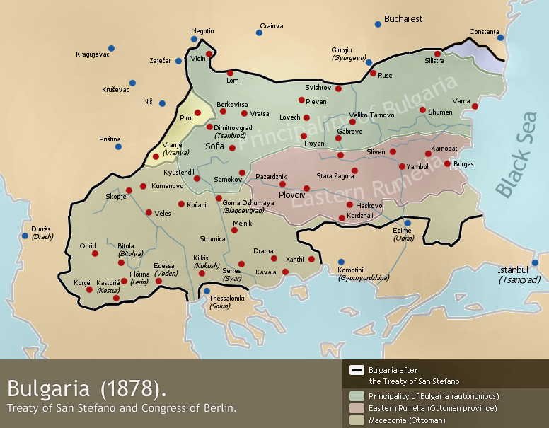
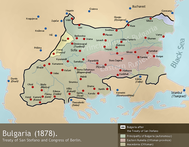
A map of Bulgaria (1878) - borders after the Treaty of San Stefano (3 March 1878) and the Congress of Berlin (June 1878).
Drawn by Todor Bozhinov (me) and released under GFDL.
Licensing[edit]
-byTodorBozhinov.png&action=edit§ion=2)
I, the copyright holder of this work, hereby publish it under the following licenses:

|
Permission is granted to copy, distribute and/or modify this document under the terms of the GNU Free Documentation License, Version 1.2 or any later version published by the Free Software Foundation; with no Invariant Sections, no Front-Cover Texts, and no Back-Cover Texts. A copy of the license is included in the section entitled GNU Free Documentation License. |
| This file is licensed under the Creative Commons Attribution-Share Alike 3.0 Unported license. | ||
| ||
| This licensing tag was added to this file as part of the GFDL licensing update. |
You may select the license of your choice.
derivative works[edit]
-byTodorBozhinov.png&action=edit§ion=3)
Derivative works of this file:
File history
Click on a date/time to view the file as it appeared at that time.
-byTodorBozhinov.png&dir=prev)
-byTodorBozhinov.png&offset=20060104191830)
-byTodorBozhinov.png&offset=&limit=20)
-byTodorBozhinov.png&offset=&limit=50)
-byTodorBozhinov.png&offset=&limit=100)
-byTodorBozhinov.png&offset=&limit=250)
-byTodorBozhinov.png&offset=&limit=500)
| Date/Time | Thumbnail | Dimensions | User | Comment | |
|---|---|---|---|---|---|
| current | 20:59, 22 July 2011 | | 776 × 605 (176 KB) | Ras67 (talk | contribs) | cropped and squeezed |
| 11:24, 4 January 2010 |  | 786 × 613 (230 KB) | TodorBozhinov (talk | contribs) | changed map name due to complaints that it's POV | |
| 11:31, 22 October 2008 |  | 786 × 613 (236 KB) | TodorBozhinov (talk | contribs) | please, reupload your edits of this version under a different name | |
| 07:08, 20 October 2008 |  | 786 × 613 (148 KB) | Pruxo (talk | contribs) | diferencia de colores | |
| 16:12, 17 February 2006 |  | 786 × 613 (236 KB) | Martyr (talk | contribs) | made darker, I discovered my monitor shows the colours somewhat dark and the image's actual colours are too light. | |
| 14:37, 26 January 2006 |  | 786 × 613 (229 KB) | Martyr (talk | contribs) | Ruse inscription was somehow erased | |
| 22:28, 23 January 2006 |  | 786 × 613 (229 KB) | Martyr (talk | contribs) | "Principality of Bulgaria" and "Eastern Rumelia" inscriptions fixed, they were somehow partly deleted. | |
| 23:28, 4 January 2006 |  | 786 × 613 (225 KB) | Martyr (talk | contribs) | correction in the northeast - the piece of Dobruja that was part of San Stefano Bulgaria but was given to Romania after the Congress of Berlin now marked. | |
| 23:11, 4 January 2006 |  | 786 × 613 (225 KB) | Martyr (talk | contribs) | "Vranja" to "Vranje (Vranya)" - Vranje is the correct contemporary Serbian name, Vranya is a transliteration of the Bulgarian one. | |
| 19:18, 4 January 2006 |  | 786 × 613 (226 KB) | Martyr (talk | contribs) | fixed wrong western border with Serbia, Pirot and Vranja were Bulgarian territory according to the Treaty of San Stefano |
You cannot overwrite this file.
File usage on Commons
The following 4 pages use this file:
File usage on other wikis
The following other wikis use this file:
- Usage on af.wikipedia.org
- Usage on ar.wikipedia.org
- Usage on ba.wikipedia.org
- Usage on be.wikipedia.org
- Usage on bg.wikipedia.org
- Usage on bs.wikipedia.org
- Usage on ca.wikipedia.org
- Usage on cs.wikipedia.org
- Usage on cy.wikipedia.org
- Usage on da.wikipedia.org
- Usage on el.wikipedia.org
- Usage on en.wikipedia.org
- Usage on eo.wikipedia.org
- Usage on fa.wikipedia.org
- Usage on fi.wikipedia.org
- Usage on fr.wikipedia.org
- Usage on he.wikipedia.org
- Usage on hr.wikipedia.org
- Usage on hy.wikipedia.org
- Usage on hyw.wikipedia.org
- Usage on it.wikipedia.org
View more global usage of this file.
-byTodorBozhinov.png)
-byTodorBozhinov.png&oldid=837727362)