File:Australia General Election 2022 -- Two-Party-Preferred Votes.svg
Jump to navigation
Jump to search

Size of this PNG preview of this SVG file: 773 × 600 pixels. Other resolutions: 309 × 240 pixels | 619 × 480 pixels | 990 × 768 pixels | 1,280 × 993 pixels | 2,560 × 1,987 pixels | 1,608 × 1,248 pixels.
Original file (SVG file, nominally 1,608 × 1,248 pixels, file size: 4.56 MB)
Captions
Captions
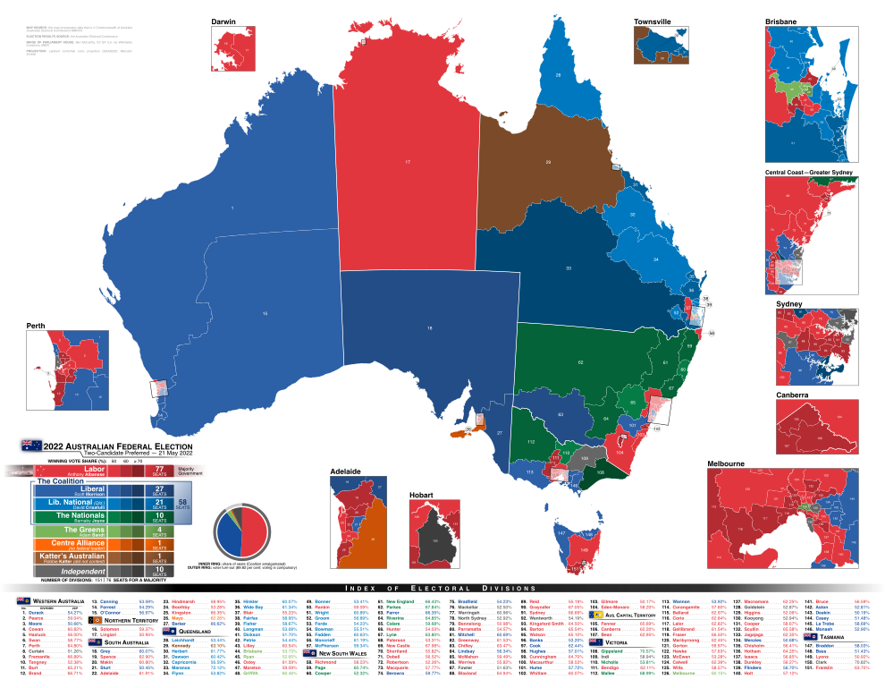
Map depicting the results of the 2022 Australian federal election, which took place on 21 May 2022, in each division (after preferences).
Summary[edit]
| Description |
English: A map showing all 151 federal electoral divisions. Each division is shown in the colour of the party that won during the 2022 Australian Federal Election in said division, after preferences. The shade of the colour indicates the vote strength of the winning party — the darker the colour, the higher the share of votes and vice versa. |
| Date | |
| Source | Own work |
| Author | Eric0892 |
Licensing[edit]
I, the copyright holder of this work, hereby publish it under the following license:
This file is licensed under the Creative Commons Attribution-Share Alike 4.0 International license.
- You are free:
- to share – to copy, distribute and transmit the work
- to remix – to adapt the work
- Under the following conditions:
- attribution – You must give appropriate credit, provide a link to the license, and indicate if changes were made. You may do so in any reasonable manner, but not in any way that suggests the licensor endorses you or your use.
- share alike – If you remix, transform, or build upon the material, you must distribute your contributions under the same or compatible license as the original.
File history
Click on a date/time to view the file as it appeared at that time.
| Date/Time | Thumbnail | Dimensions | User | Comment | |
|---|---|---|---|---|---|
| current | 19:22, 21 August 2023 | | 1,608 × 1,248 (4.56 MB) | Eric0892 (talk | contribs) | Update format to include more information and have a better designed legend and index of divisions. |
| 06:59, 18 June 2022 |  | 6,695 × 5,855 (4.48 MB) | The2016 (talk | contribs) | Updated various seats | |
| 01:48, 5 June 2022 |  | 6,695 × 5,855 (4.48 MB) | Eric0892 (talk | contribs) | Fix issues with Kennedy's offshore islands | |
| 03:06, 2 June 2022 |  | 6,695 × 5,855 (4.48 MB) | Eric0892 (talk | contribs) | Add election outcome graphic, final seat counts; p.s., thanks for filling in the results, {{u|The2016}}. | |
| 21:07, 1 June 2022 |  | 6,695 × 5,855 (4.42 MB) | The2016 (talk | contribs) | Will check over once full results are out but done in the meantime. Obviously the party list needs to be updated and the seats listed need to be colored at the bottom but aside from that there is an issue with combining some uncolored islands in Queensland that breaks the Townsville inset, I can't fix it. | |
| 05:27, 21 May 2022 |  | 6,695 × 5,855 (4.42 MB) | Eric0892 (talk | contribs) | Uploaded own work with UploadWizard |
You cannot overwrite this file.
File usage on Commons
The following 5 pages use this file:
File usage on other wikis
The following other wikis use this file:
- Usage on de.wikipedia.org
- Usage on en.wikipedia.org
- Usage on uz.wikipedia.org
- Usage on zh.wikipedia.org