File:Aegean 6 nm.svg
Jump to navigation
Jump to search

Size of this PNG preview of this SVG file: 432 × 467 pixels. Other resolutions: 222 × 240 pixels | 444 × 480 pixels | 710 × 768 pixels | 947 × 1,024 pixels | 1,894 × 2,048 pixels.
Original file (SVG file, nominally 432 × 467 pixels, file size: 219 KB)
Captions
Captions
Add a one-line explanation of what this file represents
Summary[edit]
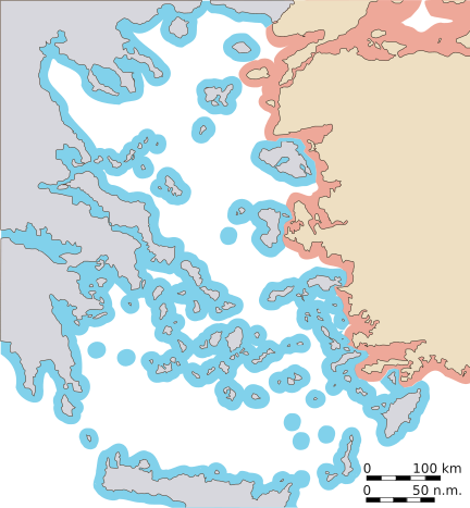
| Description | Map of the Aegean, with approximate extent of current 6nm territorial waters. To be used as illustration in en:Aegean dispute. |
| Date | |
| Source | Own work |
| Author | w:en:User:Future Perfect at Sunrise |
Licensing[edit]
I, the copyright holder of this work, hereby publish it under the following licenses:

|
Permission is granted to copy, distribute and/or modify this document under the terms of the GNU Free Documentation License, Version 1.2 or any later version published by the Free Software Foundation; with no Invariant Sections, no Front-Cover Texts, and no Back-Cover Texts. A copy of the license is included in the section entitled GNU Free Documentation License. |
| This file is licensed under the Creative Commons Attribution-Share Alike 3.0 Unported license. | ||
| ||
| This licensing tag was added to this file as part of the GFDL licensing update. |
This file is licensed under the Creative Commons Attribution-Share Alike 2.5 Generic, 2.0 Generic and 1.0 Generic license.
- You are free:
- to share – to copy, distribute and transmit the work
- to remix – to adapt the work
- Under the following conditions:
- attribution – You must give appropriate credit, provide a link to the license, and indicate if changes were made. You may do so in any reasonable manner, but not in any way that suggests the licensor endorses you or your use.
- share alike – If you remix, transform, or build upon the material, you must distribute your contributions under the same or compatible license as the original.
You may select the license of your choice.
File history
Click on a date/time to view the file as it appeared at that time.
| Date/Time | Thumbnail | Dimensions | User | Comment | |
|---|---|---|---|---|---|
| current | 23:00, 30 January 2007 | | 432 × 467 (219 KB) | Future Perfect at Sunrise (talk | contribs) | |
| 22:55, 30 January 2007 |  | 432 × 467 (219 KB) | Future Perfect at Sunrise (talk | contribs) | ||
| 22:09, 28 January 2007 |  | 435 × 470 (220 KB) | Future Perfect at Sunrise (talk | contribs) | ||
| 00:24, 28 January 2007 |  | 576 × 612 (219 KB) | Future Perfect at Sunrise (talk | contribs) | {{Information |Description=Map of the Aegean, with approximate extent of current 6nm territorial waters. To be used as illustration in w:en:Aegean dispute. |Source=Own work |Date=27 Jan 2007 |Author=w:en:User:Future Perfect at Sunrise |Permission |
You cannot overwrite this file.
File usage on Commons
There are no pages that use this file.
File usage on other wikis
The following other wikis use this file:
- Usage on ar.wikipedia.org
- Usage on ca.wikipedia.org
- Usage on ckb.wikipedia.org
- Usage on de.wikipedia.org
- Usage on el.wikipedia.org
- Usage on en.wikipedia.org
- Usage on es.wikipedia.org
- Usage on fa.wikipedia.org
- Usage on fr.wikipedia.org
- Usage on hy.wikipedia.org
- Usage on id.wikipedia.org
- Usage on jv.wikipedia.org
- Usage on ka.wikipedia.org
- Usage on mzn.wikipedia.org
- Usage on pt.wikipedia.org
- Usage on ru.wikipedia.org
- Usage on tg.wikipedia.org
- Usage on tr.wikipedia.org
- Usage on uk.wikipedia.org
- Usage on www.wikidata.org