File:025521 claddagh ring.jpg
Jump to navigation
Jump to search
No higher resolution available.
025521_claddagh_ring.jpg (640 × 480 pixels, file size: 58 KB, MIME type: image/jpeg)
Captions
Captions
Add a one-line explanation of what this file represents
Summary[edit]
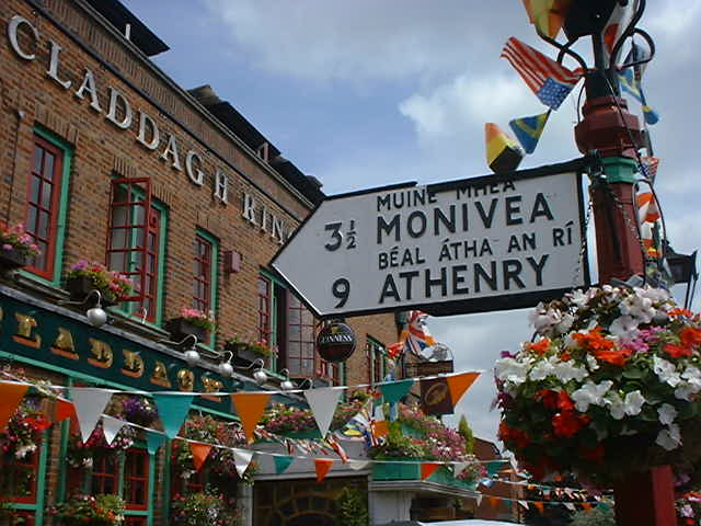
| Description | Alledgedly this pub is 9 miles from the low-lying fields of Athenry. The sign is an authentic Irish bi-lingual road sign. It was probably stolen from Or, to be more charitable, since I recently discovered that the Republic has gone metric with its road signs, this sign may have been discarded from its original location and obtained legitimately. In fact this is the Claddagh Ring public house in Church Road, Hendon, north London near the junction with Church End at Photographed 2002 June 29 13:15 (BST) |
| Date | June 29 2002 ; 29 June 2002 (according to Exif data) |
| Source | Own work |
| Author | user:RHaworth |
| Other versions |
|


| Camera location | | View this and other nearby images on: OpenStreetMap |
|---|
grid reference M574399 or thereabouts.
Licensing[edit]
| This work has been released into the public domain by its author, RHaworth. This applies worldwide. In some countries this may not be legally possible; if so: |
File history
Click on a date/time to view the file as it appeared at that time.
| Date/Time | Thumbnail | Dimensions | User | Comment | |
|---|---|---|---|---|---|
| current | 17:26, 17 February 2005 | | 640 × 480 (58 KB) | RHaworth (talk | contribs) | Claddagh Ring Pub, Church Road, Hendon |
You cannot overwrite this file.
File usage on Commons
The following 4 pages use this file:
File usage on other wikis
The following other wikis use this file:
- Usage on af.wikipedia.org
- Usage on azb.wikipedia.org
- Usage on cs.wikipedia.org
- Usage on en.wikipedia.org
- Usage on gl.wikipedia.org
- Usage on he.wikipedia.org
- Usage on it.wikipedia.org
- Usage on la.wikipedia.org
- Usage on pt.wikipedia.org
- Usage on vi.wikipedia.org