Dutch Caribbean
The Dutch Caribbean (historically known as the Dutch West Indies) are the New World territories, colonies, and countries (former and current) of the Dutch Empire and the Kingdom of the Netherlands located in the Caribbean Sea, mainly the northern and southwestern regions of the Lesser Antilles archipelago.
 | |
 Location of the Dutch Caribbean islands | |
| Area | 980 km2 (380 sq mi) |
|---|---|
| Population (as of January 2019) | 337,617 |
| GDP (Nominal) | US$8.911 billion |
| GDP per Capita (Nominal) | US$29,240 |
| Density | 343/km2 (890/sq mi) |
| Languages | Dutch, English, Papiamento |
| Government | 3 constituent countries 3 special municipalities |
Currently, it comprises the constituent countries of Curaçao, Aruba and Sint Maarten (the 'CAS' islands) and the special municipalities of Bonaire, Sint Eustatius and Saba (BES islands). The term "Dutch Caribbean" is sometimes also used for the Caribbean Netherlands, an entity consisting of the three special municipalities forming part of the constituent country of the Netherlands since 2010. The Dutch Caribbean had a population of 337,617 as of January 2019.
History

The islands of the Dutch Caribbean were, formerly, part of Curaçao and Dependencies (1815–1828), or Sint Eustatius and Dependencies (1815–1828), which were merged with the colony of Suriname (not actually considered part of the "Dutch Caribbean", although it is located on the Caribbean coast of northeastern South America). Until 1845, they were governed from Paramaribo, Suriname, at which point all the islands, again, became part of Curaçao and Dependencies.
In 1954, the islands became the land (Dutch for "country") of Netherlands Antilles, lasting until 2010. The autonomy of the Netherlands Antilles' island territories was stipulated in the Islands Regulation of the Netherlands Antilles. Initially, the Netherlands Antilles consisted of four island territories—Aruba, Bonaire, Curaçao and the Windward Islands. The latter split into the Island Territories of Saba, Sint Eustatius and Sint Maarten, in 1983.
The island of Aruba seceded from the Netherlands Antilles in 1986 to become a separate constituent country of the Kingdom of the Netherlands, leaving five island territories within the Netherlands Antilles. This arrangement lasted until the complete dissolution of the Netherlands Antilles, as a unified political entity, in 2010; that year, Curaçao and Sint Maarten became autonomous constituent countries within the Kingdom (like Aruba). Bonaire, Sint Eustatius and Saba became special municipalities of the Netherlands proper (located on the European mainland), a member state of the European Union.
Geography


Geographically, the six entities of the Dutch Caribbean are clustered into two vastly separated areas of the Caribbean:
- Three are at the far northern end of the Leeward Islands, thus, the far northern end of the Lesser Antilles. From north to south, these are Sint Maarten (occupying roughly the southern half of the island of Saint Martin), Saba, and Sint Eustatius.
- From west to east, Aruba, Curaçao and Bonaire are located just off of the Caribbean coastline of northern Venezuela, at the far western end of the Leeward Antilles (which extend west from the southern end of the Windward Islands—thus they are at the southwestern end of the Lesser Antilles).
Politically, each (six) entity of the Dutch Caribbean currently has one of two relationships with the Netherlands:
- Three have the status of being constituent countries of the Kingdom of the Netherlands.
- Three have the status of being special municipalities of the Netherlands alone, as distinct from the Kingdom in its entirety.
Constituent countries
Three Caribbean polities are landen (Dutch for "countries") within the Kingdom of the Netherlands: Aruba, Curaçao, and Sint Maarten. The Netherlands is the fourth and largest constituent country in the Kingdom.
Sint Maarten comprises the southern half of the island of Saint Martin. The northern half of the island (the Collectivity of Saint Martin) is an overseas territory of France. Aruba and Curaçao are located in the far south of the Caribbean, roughly 30 kilometres and 65 kilometres from the coast of Venezuela, respectively.
Special municipalities

The three Caribbean islands that are special municipalities of the Netherlands alone are Bonaire, Sint Eustatius, and Saba. Abbreviated collectively, these are also known as the "BES islands", or the Caribbean Netherlands. Bonaire is located in the far south of the Caribbean, being about 80 kilometres north of the coast of Venezuela; Saba is located about 50 kilometres south of Sint Maarten, and boasts the highest mountain in the Netherlands, Mount Scenery, at 880 m (2,887') above sea level). Sint Eustatius is located directly north of Saint Kitts.
Dutch Caribbean islands
| ||||||||||||||||||||||||||||||||||||||||||||||||||||||||||||||||||||||||


Photo gallery
-
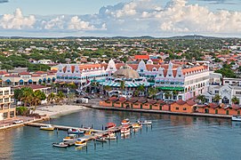 Oranjestad, Aruba
 -
 Bonaire
 -
 Curacao
 -
 Mount Scenery, Saba
 -
 Sint Eustatius
 -
 Sint Maarten

.jpg)


.jpg)

Grouping of islands
The islands have also been informally grouped in the following ways.
- Geographically, by location in the Lesser Antilles (in alphabetical order):
- ABC islands, for Aruba, Bonaire, and Curaçao (within the Leeward Antilles group)
- SSS islands, for Saba, Sint Eustatius, and Sint Maarten (within the Leeward Islands group)
- Politically, by constitutional status (in order of population size):
- CAS islands, for Curaçao, Aruba, and Sint Maarten (constituent countries of the Kingdom of the Netherlands)
- BES islands, for Bonaire, Sint Eustatius, and Saba (special municipalities of the Netherlands)
See also
Notes
References
External links
This article uses material from the Wikipedia English article Dutch Caribbean, which is released under the Creative Commons Attribution-ShareAlike 3.0 license ("CC BY-SA 3.0"); additional terms may apply (view authors). Content is available under CC BY-SA 4.0 unless otherwise noted. Images, videos and audio are available under their respective licenses.
®Wikipedia is a registered trademark of the Wiki Foundation, Inc. Wiki English (DUHOCTRUNGQUOC.VN) is an independent company and has no affiliation with Wiki Foundation.