File:UN headquarters Haiti after 2010 earthquake.jpg
Jump to navigation
Jump to search

Size of this preview: 800 × 533 pixels. Other resolutions: 320 × 213 pixels | 640 × 427 pixels | 1,024 × 683 pixels | 1,280 × 853 pixels | 3,000 × 2,000 pixels.
Original file (3,000 × 2,000 pixels, file size: 1.6 MB, MIME type: image/jpeg)
Captions
Captions
Add a one-line explanation of what this file represents
| Description |
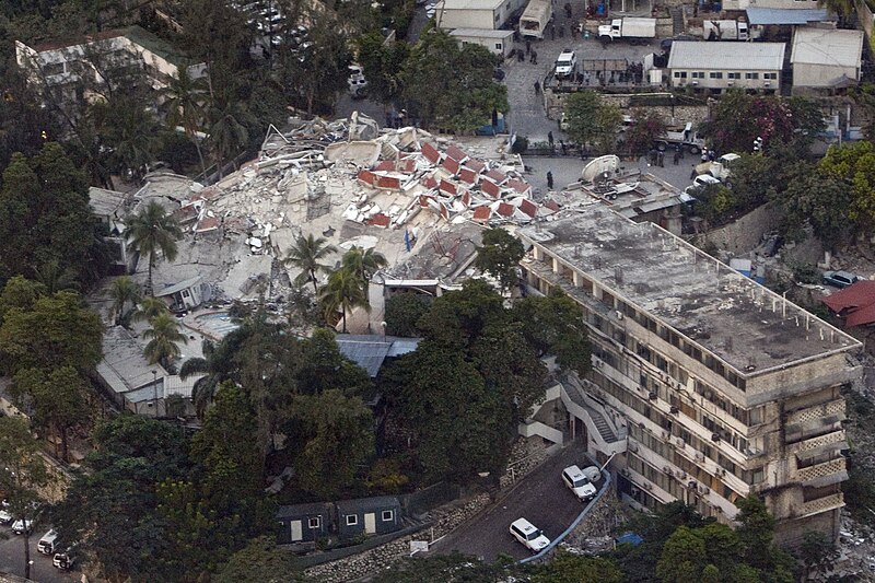
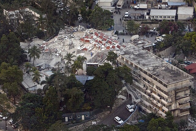
English: An aerial view of the UN headquarters in Haiti shows the devastation caused by an earthquake measuring 7 plus on the Richter scale rocked Port au Prince Haiti just before 5 pm, January 12, 2010.
Español: Vista aérea de la sede de la ONU en Haití mostrando la destrucción producida por el terremoto de 7 grados en la escala de Richter que sacudió Puerto Príncipe poco antes de las 5 de la tarde del 12 de enero de 2010.
Suomi: 12. tammikuuta 2010 tapahtuneessa maanjäristyksessä pahoin vaurioitunut Yhdistyneiden Kansakuntien Haitin operaation päämaja Port-au-Princessä, Haitissa
Français : Vue aérienne du siège de l'ONU à Haïti montrant la destruction causée par un tremblement de terre de magnitude 7 sur l'échelle de Richter qui frappa Port-au-Prince peu avant 5 heures, le 12 janvier 2010.
Deutsch: Das Luftbild zeigt die zerstörte Einsatzzentrale (Hotel Christopher) der MINUSTAH-Mission der UN auf Haiti nach einem Erdbeben der Stärke 7 Mw (w:de:Momenten-Magnituden-Skala) am 12. Januar 2010 um 21:53:10 UTC bzw. 16:53:10 Uhr Ortszeit.
(18.53908° N, -72.312087° W)
Русский: Штаб-квартира ООН в Порт-о-Пренс, Гаити после землетрясения 12 января 2010 года.
Italiano: La sede dell'ONU a Port-au-Prince, Haiti non potrebbe evitare il collasso parziale al terremoto del 12 gennaio 2010. |
||
| Date | |||
| Source | originally posted to Flickr as Peacekeeping - MINUSTAH | ||
| Author | UN Photo/Logan Abassi UNDP Global | ||
| Permission (Reusing this file) |
This file is licensed under the Creative Commons Attribution 2.0 Generic license.
|
| Object location | | View this and other nearby images on: OpenStreetMap |
|---|
File history
Click on a date/time to view the file as it appeared at that time.
| Date/Time | Thumbnail | Dimensions | User | Comment | |
|---|---|---|---|---|---|
| current | 18:42, 14 January 2010 | | 3,000 × 2,000 (1.6 MB) | Flickr upload bot (talk | contribs) | Uploaded from http://flickr.com/photo/37913760@N03/4273890959 using Flickr upload bot |
You cannot overwrite this file.
File usage on Commons
The following 2 pages use this file:
- Haiti
- File:UN headquarters Haiti after earthquake.jpg (file redirect)
File usage on other wikis
The following other wikis use this file:
- Usage on ar.wikipedia.org
- Usage on ast.wikipedia.org
- Usage on be.wikipedia.org
- Usage on bg.wikipedia.org
- Usage on ca.wikipedia.org
- Usage on ckb.wikipedia.org
- Usage on cs.wikipedia.org
- Usage on da.wikipedia.org
- Usage on de.wikipedia.org
- Usage on el.wikipedia.org
- Usage on en.wikipedia.org
- Usage on en.wikibooks.org
- Usage on en.wikinews.org
- Usage on en.wikiversity.org
- Usage on en.wiktionary.org
- Usage on es.wikipedia.org
- Usage on fa.wikipedia.org
- Usage on fr.wikipedia.org
- Usage on gl.wikipedia.org
- Usage on hu.wikipedia.org
- Usage on it.wikipedia.org
- Usage on mzn.wikipedia.org
- Usage on nl.wikipedia.org
- Usage on no.wikipedia.org
- Usage on pl.wikinews.org
- Usage on ru.wikipedia.org
- Usage on ru.wikiversity.org
- Usage on simple.wikipedia.org
- Usage on sv.wikipedia.org
- Usage on sw.wikipedia.org
- Usage on www.wikidata.org
- Usage on zh.wikipedia.org