File:Montenegro during ww2.png
Jump to navigation
Jump to search

Size of this preview: 437 × 599 pixels. Other resolutions: 175 × 240 pixels | 350 × 480 pixels | 670 × 918 pixels.
Original file (670 × 918 pixels, file size: 49 KB, MIME type: image/png)
Captions
Captions
Add a one-line explanation of what this file represents
Summary[edit]
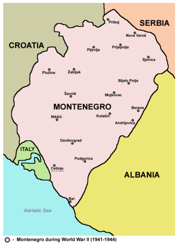
- English: Map of Montenegro during World War II (1941-1944).
- Serbian / Montenegrin: Mapa Crne Gore u Drugom svetskom ratu (od 1941. do 1944. godine).
Source and licence[edit]
- Map from English Wikipedia
- self made by user:PANONIAN
| This work has been released into the public domain by its author, PANONIAN. This applies worldwide. In some countries this may not be legally possible; if so: |
References[edit]
Borders of Montenegro are primarily based on this source:
Other secondary sources:
- Istorijski atlas, Geokarta, Beograd, 1999.
- Denis Šehić - Demir Šehić, Školski istorijski atlas Sveta, Beograd, 2007.
- Školski istorijski atlas, Zavod za izdavanje udžbenika SR Srbije, Beograd, 1970.
- Sve srpske mape - od šestog veka do Pariza, Specijalno izdanje BLICA, Decembar 1995. godine.
- The Times - History of Europe, Times Books, London, 2002.
- Richard Overy, The Times - History of the 20th Century, Times Books, London, 2004.
- Valter Manošek, Holokaust u Srbiji, Beograd, 2007.
- Nenad Stefanović, Jedan svet na Dunavu, Beograd, 2003.
- Dr Tomislav Bogavac, Nestajanje Srba, Niš, 1994.
- Petrit Imami, Srbi i Albanci kroz vekove, Beograd, 2000.
- Tim Džuda, Srbi - istorija, mit i razaranje Jugoslavije, Beograd, 2003.
- Fransisko Veiga, Balkanska zamka (1804-2001), Beograd, 2003.
- Džon R. Lempi, Jugoslavija kao istorija, Beograd, 2004.
- http://www.svetskirat.net/slike/razbijanje/zazbijanje_jugoslavije_1941.jpg
- http://www.marxists.org/subject/yugoslavia/images/maps/1941-dismemberment.jpg
- http://www.srpska-mreza.com/MAPS/Yugoslavia/YU-Nazi-division.jpg
- http://terkepek.adatbank.transindex.ro/kepek/netre/211.gif
File history
Click on a date/time to view the file as it appeared at that time.
| Date/Time | Thumbnail | Dimensions | User | Comment | |
|---|---|---|---|---|---|
| current | 07:58, 9 September 2012 | | 670 × 918 (49 KB) | PANONIAN (talk | contribs) | improved version |
| 15:35, 10 July 2007 |  | 519 × 722 (32 KB) | Slav (talk | contribs) | *Map from English Wikipedia *Map of Montenegro during World War II (self made) {{PD-self}} |
You cannot overwrite this file.
File usage on Commons
The following 2 pages use this file:
File usage on other wikis
The following other wikis use this file:
- Usage on az.wikipedia.org
- Usage on be-tarask.wikipedia.org
- Usage on be.wikipedia.org
- Usage on bg.wikipedia.org
- Usage on bs.wikipedia.org
- Usage on ca.wikipedia.org
- Usage on cs.wikipedia.org
- Usage on cv.wikipedia.org
- Usage on da.wikipedia.org
- Usage on el.wikipedia.org
- Usage on eo.wikipedia.org
- Usage on fo.wikipedia.org
- Usage on fr.wikipedia.org
- Usage on gl.wikipedia.org
- Usage on he.wikipedia.org
- Usage on hr.wikipedia.org
- Usage on id.wikipedia.org
- Usage on is.wikipedia.org
- Usage on it.wikipedia.org
- Usage on ja.wikipedia.org
- Usage on jv.wikipedia.org
- Usage on ko.wikipedia.org
- Usage on lt.wikipedia.org
- Usage on nl.wikipedia.org
- Usage on no.wikipedia.org
- Usage on pl.wikipedia.org
- Usage on pt.wikipedia.org
- Usage on ro.wikipedia.org
- Usage on ru.wikipedia.org
View more global usage of this file.