File:Επαρχίες της Μακεδονικής αυτοκρατορίας.svg
Jump to navigation
Jump to search

Size of this PNG preview of this SVG file: 800 × 364 pixels. Other resolutions: 320 × 146 pixels | 640 × 291 pixels | 1,024 × 466 pixels | 1,280 × 583 pixels | 2,560 × 1,166 pixels | 2,828 × 1,288 pixels.
Original file (SVG file, nominally 2,828 × 1,288 pixels, file size: 628 KB)
Captions
Captions
Add a one-line explanation of what this file represents
Summary[edit]
| Description |
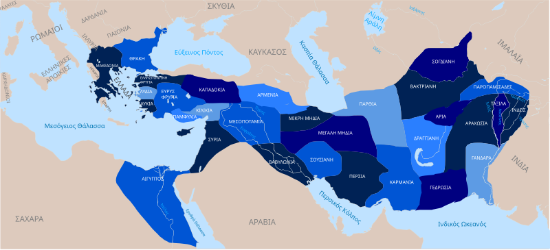
Ελληνικά: Επαρχίες της Μακεδονικής αυτοκρατορίας το 323 (Συμφωνία της Βαβυλώνας) με 321 π.Χ. (Συμφωνία του Τριπαραδείσου)
English: Divisions of the Macedonian Empire between 323 (Partition of Babylon) and 321 B.C. (Partition of Triparadeisus) |
| Date | |
| Source |
|
| Author | George Tsiagalakis, original map by GMT Hawaii edu |
| Other versions |

This W3C-unspecified vector image was created with Inkscape .
Licensing[edit]
I, the copyright holder of this work, hereby publish it under the following license:
This file is licensed under the Creative Commons Attribution-Share Alike 3.0 Unported license.
- You are free:
- to share – to copy, distribute and transmit the work
- to remix – to adapt the work
- Under the following conditions:
- attribution – You must give appropriate credit, provide a link to the license, and indicate if changes were made. You may do so in any reasonable manner, but not in any way that suggests the licensor endorses you or your use.
- share alike – If you remix, transform, or build upon the material, you must distribute your contributions under the same or compatible license as the original.
File history
Click on a date/time to view the file as it appeared at that time.
| Date/Time | Thumbnail | Dimensions | User | Comment | |
|---|---|---|---|---|---|
| current | 20:15, 1 February 2015 | | 2,828 × 1,288 (628 KB) | Gts-tg (talk | contribs) | ΦΟΙΝΙΚΗ to ΣΥΡΙΑ |
| 19:37, 1 February 2015 |  | 2,828 × 1,288 (628 KB) | Gts-tg (talk | contribs) | Corrections on map(Persia to Susa, Iran to Persia, Punjab to Taxila, added Akesinis river) and colour changes | |
| 14:11, 1 December 2014 |  | 2,828 × 1,288 (797 KB) | Gts-tg (talk | contribs) | Fixed errors and improved colours | |
| 21:46, 28 November 2014 |  | 2,828 × 1,288 (797 KB) | Gts-tg (talk | contribs) | Changed coloration, and new font colour makes names stand out better | |
| 22:12, 27 November 2014 |  | 2,828 × 1,288 (797 KB) | Gts-tg (talk | contribs) | Corrected minor errors | |
| 21:44, 27 November 2014 |  | 2,828 × 1,288 (797 KB) | Gts-tg (talk | contribs) | User created page with UploadWizard |
You cannot overwrite this file.
File usage on Commons
There are no pages that use this file.
File usage on other wikis
The following other wikis use this file:
- Usage on el.wikipedia.org
- Αλέξανδρος ο Μέγας
- Μεσοποταμία
- Παρθία
- Αρία
- Μηδία
- Διάδοχοι του Μεγάλου Αλεξάνδρου
- Αλεξάνδρεια στον Καύκασο
- Συζήτηση χρήστη:Gts-tg/Διάλογοι Β´
- Γανδάρα
- Γεδρωσία
- Καρμανία
- Δραγγιανή
- Πείθων του Αγήνορα
- Οξυάρτης
- Σιβύρτιος (σατράπης)
- Πόλεμοι των Διαδόχων
- Αραχωσία
- Παροπαμισάδες
- Συμφωνία του Τριπαραδείσου
- Συμφωνία της Βαβυλώνας
- Usage on eu.wikipedia.org
- Usage on hyw.wikipedia.org
- Usage on it.wikipedia.org