Infobox Settlement
This template is aliased or used as a sub-template for several infobox front-end templates.
| This ढाँचा employs intricate features of template syntax. You are encouraged to familiarise yourself with its setup and parser functions before editing the template. If your edit causes unexpected problems, please undo it quickly, as this template may appear on a large number of pages. You can conduct experiments, and should test all major changes, in either this template's sandbox, the general template sandbox, or your user space before changing anything here. |
| This template uses Lua: |
This template uses the Wikidata property:
|
It should be used to produce an Infobox for human settlements (cities, towns, villages, communities) as well as other administrative districts, counties, provinces, et cetera—in fact, any subdivision below the level of a country, for which {{Infobox country}} should be used. Parameters are described in the table below. For questions, see the talk page. For a U.S. city guideline, see WP:USCITIES.
Usage
- Important: Please enter all numeric values in a raw, unformatted fashion. References are to be included in their respective section footnotes field. Numeric values that are not "raw" may create an "Expression error". Raw values will be automatically formatted by the template. If you find a raw value is not formatted in your usage of the template, please post a notice on the discussion page for this template.
- An expression error may also occur when any coordinate parameter has a value, but one or more coordinate parameters are blank or invalid.
Basic blank template, ready to cut and paste. See the next section for a copy of the template with all parameters and comments. See the table below that for a full description of each parameter.
Using metric units
{{Infobox settlement | name = | native_name = | native_name_lang = | settlement_type = | image_skyline = | image_alt = | image_caption = | image_flag = | flag_alt = | image_seal = | seal_alt = | image_shield = | shield_alt = | etymology = | nickname = | motto = | image_map = | map_alt = | map_caption = | pushpin_map = | pushpin_map_alt = | pushpin_map_caption = | pushpin_label_position = | coordinates = | coor_pinpoint = | coordinates_footnotes = | subdivision_type = Country | subdivision_name = | subdivision_type1 = | subdivision_name1 = | subdivision_type2 = | subdivision_name2 = | subdivision_type3 = | subdivision_name3 = | established_title = | established_date = | founder = | seat_type = | seat = | government_footnotes = | government_type = | governing_body = | leader_party = | leader_title = | leader_name = | leader_title1 = | leader_name1 = | leader_title2 = | leader_name2 = | leader_title3 = | leader_name3 = | leader_title4 = | leader_name4 = | unit_pref = Metric | area_footnotes = | area_urban_footnotes = | area_rural_footnotes = | area_metro_footnotes = | area_magnitude = | area_note = | area_water_percent = | area_rank = | area_blank1_title = | area_blank2_title = | area_total_km2 = | area_land_km2 = | area_water_km2 = | area_urban_km2 = | area_rural_km2 = | area_metro_km2 = | area_blank1_km2 = | area_blank2_km2 = | area_total_ha = | area_land_ha = | area_water_ha = | area_urban_ha = | area_rural_ha = | area_metro_ha = | area_blank1_ha = | area_blank2_ha = | length_km = | width_km = | dimensions_footnotes = | elevation_footnotes = | elevation_m = | population_as_of = | population_footnotes = | population_total = | population_density_km2 = auto | population_note = | population_demonym = | timezone1 = | utc_offset1 = | timezone1_DST = | utc_offset1_DST = | postal_code_type = | postal_code = | area_code_type = | area_code = | iso_code = | website = | footnotes = }} Using non-metric units
{{Infobox settlement | name = | native_name = | native_name_lang = | settlement_type = | image_skyline = | image_alt = | image_caption = | image_flag = | flag_alt = | image_seal = | seal_alt = | image_shield = | shield_alt = | etymology = | nickname = | motto = | image_map = | map_alt = | map_caption = | pushpin_map = | pushpin_map_alt = | pushpin_map_caption = | pushpin_label_position = | coordinates = | coor_pinpoint = | coordinates_footnotes = | subdivision_type = Country | subdivision_name = | subdivision_type1 = | subdivision_name1 = | subdivision_type2 = | subdivision_name2 = | subdivision_type3 = | subdivision_name3 = | established_title = | established_date = | founder = | seat_type = | seat = | government_footnotes = | leader_party = | leader_title = | leader_name = | unit_pref = US | area_footnotes = | area_urban_footnotes = | area_rural_footnotes = | area_metro_footnotes = | area_magnitude = | area_note = | area_water_percent = | area_rank = | area_blank1_title = | area_blank2_title = | area_total_sq_mi = | area_land_sq_mi = | area_water_sq_mi = | area_urban_sq_mi = | area_rural_sq_mi = | area_metro_sq_mi = | area_blank1_sq_mi = | area_blank2_sq_mi = | area_total_acre = | area_land_acre = | area_water_acre = | area_urban_acre = | area_rural_acre = | area_metro_acre = | area_blank1_acre = | area_blank2_acre = | length_mi = | width_mi = | dimensions_footnotes = | elevation_footnotes = | elevation_ft = | population_as_of = | population_footnotes = | population_total = | population_density_sq_mi= auto | population_note = | population_demonym = | timezone1 = | utc_offset1 = | timezone1_DST = | utc_offset1_DST = | postal_code_type = | postal_code = | area_code_type = | area_code = | iso_code = | website = | footnotes = }} Short version
{{Infobox settlement | name = | native_name = | native_name_lang = | settlement_type = | image_skyline = | image_alt = | image_caption = | etymology = | nickname = | coordinates = | population_total = | subdivision_type = Country | subdivision_name = | subdivision_type1 = | subdivision_name1 = | subdivision_type2 = | subdivision_name2 = | website = }} Complete empty syntax, with comments
This copy of the template lists all parameters except for some of the repeating numbered parameters which are noted in the comments. Comments here should be brief; see the table below for full descriptions of each parameter.
{{Infobox settlement | name = | official_name = | native_name = | native_name_lang = | other_name = | settlement_type = | translit_lang1 = | translit_lang1_type = | translit_lang1_info = | translit_lang1_type1 = | translit_lang1_info1 = | translit_lang1_type2 = | translit_lang1_info2 = | translit_lang2 = | translit_lang2_type = | translit_lang2_info = | translit_lang2_type1 = | translit_lang2_info1 = | translit_lang2_type2 = | translit_lang2_info2 = | image_skyline = | imagesize = | image_alt = | image_caption = | image_flag = | flag_size = | flag_alt = | flag_border = | flag_link = | image_seal = | seal_size = | seal_alt = | seal_link = | seal_type = | image_shield = | shield_size = | shield_alt = | shield_link = | image_blank_emblem = | blank_emblem_type = | blank_emblem_size = | blank_emblem_alt = | blank_emblem_link = | etymology = | nickname = | nicknames = | motto = | mottoes = | anthem = | image_map = | mapsize = | map_alt = | map_caption = | image_map1 = | mapsize1 = | map_alt1 = | map_caption1 = | pushpin_map = | pushpin_mapsize = | pushpin_map_alt = | pushpin_map_caption = | pushpin_map_caption_notsmall = | pushpin_label = | pushpin_label_position = | pushpin_outside = | pushpin_relief = | pushpin_image = | pushpin_overlay = | coordinates = | coor_pinpoint = | coordinates_footnotes = | grid_name = | grid_position = | subdivision_type = Country | subdivision_name = | subdivision_type1 = | subdivision_name1 = | subdivision_type2 = | subdivision_name2 = | established_title = | established_date = | established_title1 = | established_date1 = | established_title2 = | established_date2 = | established_title3 = | established_date3 = | established_title4 = | established_date4 = | established_title5 = | established_date5 = | established_title6 = | established_date6 = | established_title7 = | established_date7 = | extinct_title = | extinct_date = | founder = | named_for = | seat_type = | seat = | seat1_type = | seat1 = | parts_type = | parts_style = | parts = | p1 = | p2 = | government_footnotes = | government_type = | governing_body = | leader_party = | leader_title = | leader_name = | leader_title1 = | leader_name1 = | total_type = | unit_pref = | area_footnotes = | area_magnitude = | dunam_link = | area_total_km2 = | area_total_sq_mi = | area_total_ha = | area_total_acre = | area_total_dunam = | area_land_km2 = | area_land_sq_mi = | area_land_ha = | area_land_acre = | area_land_dunam = | area_water_km2 = | area_water_sq_mi = | area_water_ha = | area_water_acre = | area_water_dunam = | area_water_percent = | area_urban_footnotes = | area_urban_km2 = | area_urban_sq_mi = | area_urban_ha = | area_urban_acre = | area_urban_dunam = | area_rural_footnotes = | area_rural_km2 = | area_rural_sq_mi = | area_rural_ha = | area_rural_acre = | area_rural_dunam = | area_metro_footnotes = | area_metro_km2 = | area_metro_sq_mi = | area_metro_ha = | area_metro_acre = | area_metro_dunam = | area_rank = | area_blank1_title = | area_blank1_km2 = | area_blank1_sq_mi = | area_blank1_ha = | area_blank1_acre = | area_blank1_dunam = | area_blank2_title = | area_blank2_km2 = | area_blank2_sq_mi = | area_blank2_ha = | area_blank2_acre = | area_blank2_dunam = | area_note = | dimensions_footnotes = | length_km = | length_mi = | width_km = | width_mi = | elevation_footnotes = | elevation_m = | elevation_ft = | elevation_point = | elevation_max_footnotes = | elevation_max_m = | elevation_max_ft = | elevation_max_point = | elevation_max_rank = | elevation_min_footnotes = | elevation_min_m = | elevation_min_ft = | elevation_min_point = | elevation_min_rank = | population_as_of = | population_footnotes = | population_total = | pop_est_as_of = | pop_est_footnotes = | population_est = | population_rank = | population_density_km2 = | population_density_sq_mi= | population_urban_footnotes = | population_urban = | population_density_urban_km2 = | population_density_urban_sq_mi = | population_rural_footnotes = | population_rural = | population_density_rural_km2 = | population_density_rural_sq_mi = | population_metro_footnotes = | population_metro = | population_density_metro_km2 = | population_density_metro_sq_mi = | population_density = | population_density_rank = | population_blank1_title = | population_blank1 = | population_density_blank1_km2 = | population_density_blank1_sq_mi= | population_blank2_title = | population_blank2 = | population_density_blank2_km2 = | population_density_blank2_sq_mi= | population_demonym = | population_demonyms = | population_note = | demographics_type1 = | demographics1_footnotes = | demographics1_title1 = | demographics1_info1 = | demographics_type2 = | demographics2_footnotes = | demographics2_title1 = | demographics2_info1 = | timezone1 = | utc_offset1 = | timezone1_DST = | utc_offset1_DST = | timezone2 = | utc_offset2 = | timezone2_DST = | utc_offset2_DST = | postal_code_type = | postal_code = | postal2_code_type = | postal2_code = | area_code_type = | area_code = | area_codes = | geocode = | iso_code = | registration_plate_type = | registration_plate = | blank_name_sec1 = | blank_info_sec1 = | blank1_name_sec1 = | blank1_info_sec1 = | blank2_name_sec1 = | blank2_info_sec1 = | blank_name_sec2 = | blank_info_sec2 = | blank1_name_sec2 = | blank1_info_sec2 = | blank2_name_sec2 = | blank2_info_sec2 = | website = | footnotes = }} Parameter names and descriptions
Examples
- Example 1
Chicago | |||
|---|---|---|---|
City | |||
 Clockwise from top: Downtown Chicago, the Chicago Theatre, the Chicago 'L', Navy Pier, Millennium Park, the Field Museum, and the Willis (formerly Sears) Tower | |||
| |||
| Etymology: Miami-Illinois: shikaakwa ("wild onion" or "wild garlic") | |||
| Nickname(s): The Windy City, The Second City, Chi-Town, Chi-City, Hog Butcher for the World, City of the Big Shoulders, The City That Works, and others found at List of nicknames for Chicago | |||
| Motto(s): ल्याटिन: Urbs in Horto (City in a Garden), Make Big Plans (Make No Small Plans), I Will | |||
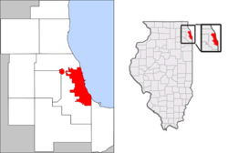 Location in the Chicago metropolitan area and Illinois | |||
 Chicago Location in the United States | |||
| निर्देशाङ्क: 41°50′15″N 87°40′55″W / 41.83750°N 87.68194°W | |||
| Country | United States | ||
| State | Illinois | ||
| Counties | Cook, DuPage | ||
| Settled | 1770s | ||
| Incorporated | March 4, 1837 | ||
| Named for | Miami-Illinois: shikaakwa ("Wild onion") | ||
| सरकार | |||
| • प्रकार | Mayor–council | ||
| • Mayor | Rahm Emanuel (D) | ||
| • Council | Chicago City Council | ||
| क्षेत्रफल | |||
| • City | [[१ E+अभिव्यक्ति त्रुटि: नपछड्याको विराम चिन्ह चरित्र "६"।_m²|२३४.११४ sq mi]] (६०६.३५ km२) | ||
| • Land | २२७.६३५ sq mi (५८९.५७ km२) | ||
| • Water | ६.४७९ sq mi (१६.७८ km२) 3% | ||
| • Urban | २,१२३ sq mi (५,५०० km२) | ||
| • Metro | १०,८७४ sq mi (२८,१६० km२) | ||
| Elevation | ५९४ ft (१८१ m) | ||
| जनसङ्ख्या (2010) | |||
| • City | २,६९५,५९८ | ||
| • Estimate (2011) | २,७०७,१२० | ||
| • क्रम | 3rd US | ||
| • जनघनत्व | ११,८९२.४/sq mi (४,५९१.७/km२) | ||
| • Urban | ८,७११,००० | ||
| • Urban density | ४,१००/sq mi (१,६००/km२) | ||
| • Metro | ९,४६१,१०५ | ||
| • Metro density | ८७०/sq mi (३४०/km२) | ||
| बासिन्दा(हरु) | Chicagoan | ||
| समय क्षेत्र | युटिसी−06:00 (CST) | ||
| • Summer (DST) | युटिसी−05:00 (CDT) | ||
| Area codes | 312, 773, 872 | ||
| FIPS code | 17-14000 | ||
| GNIS feature ID | 423587, 428803 | ||
| वेबसाइट | www | ||


{{Infobox settlement | name = Chicago | settlement_type = [[City (Illinois)|City]] | image_skyline = Chicago montage.jpg | imagesize = 275px | image_caption = Clockwise from top: [[Downtown Chicago]], the [[Chicago Theatre]], the [[Chicago 'L']], [[Navy Pier]], [[Millennium Park]], the [[Field Museum]], and the [[Willis Tower|Willis (formerly Sears) Tower]] | image_flag = Flag of Chicago, Illinois.svg | image_seal = Seal of Chicago, Illinois.svg | etymology = {{lang-mia|shikaakwa}} ("wild onion" or "wild garlic") | nickname = [[Origin of Chicago's "Windy City" nickname|The Windy City]], The Second City, Chi-Town, Chi-City, Hog Butcher for the World, City of the Big Shoulders, The City That Works, and others found at [[List of nicknames for Chicago]] | motto = {{lang-la|Urbs in Horto}} (''City in a Garden''), Make Big Plans (Make No Small Plans), I Will | image_map = US-IL-Chicago.png | map_caption = Location in the [[Chicago metropolitan area]] and Illinois | pushpin_map = USA | pushpin_map_caption = Location in the United States | coordinates = {{coord|41|50|15|N|87|40|55|W}} | coordinates_footnotes = name="USCB Gazetteer 2010"/> | subdivision_type = Country | subdivision_name = United States | subdivision_type1 = State | subdivision_name1 = [[Illinois]] | subdivision_type2 = [[List of counties in Illinois|Counties]] | subdivision_name2 = [[Cook County, Illinois|Cook]], [[DuPage County, Illinois|DuPage]] | established_title = Settled | established_date = 1770s | established_title2 = [[Municipal corporation|Incorporated]] | established_date2 = March 4, 1837 | founder = | named_for = {{lang-mia|shikaakwa}} /> ("Wild onion") | government_type = [[Mayor–council government|Mayor–council]] | leader_title = [[Mayor of Chicago|Mayor]] | leader_name = [[Rahm Emanuel]] | leader_party = [[Democratic Party (United States)|D]] | leader_title1 = [[City council|Council]] | leader_name1 = [[Chicago City Council]] | unit_pref = Imperial | area_footnotes = name="USCB Gazetteer 2010">{{cite web | url = https://www.census.gov/geo/www/gazetteer/files/Gaz_places_national.txt | title = 2010 United States Census Gazetteer for Places: January 1, 2010 | format = text | work = 2010 United States Census | publisher = [[United States Census Bureau]] | date = April 2010 | accessdate = August 1, 2012}} | area_magnitude = 1 E+8 | area_total_sq_mi = 234.114 | area_land_sq_mi = 227.635 | area_water_sq_mi = 6.479 | area_water_percent = 3 | area_urban_sq_mi = 2123 | area_metro_sq_mi = 10874 | elevation_footnotes = name="GNIS"/> | elevation_ft = 594 | elevation_m = 181 | population_as_of = [[2010 United States Census|2010]] | population_footnotes = name="USCB PopEstCities 2011">{{cite web | url = https://www.census.gov/popest/data/cities/totals/2011/tables/SUB-EST2011-01.csv | title = Annual Estimates of the Resident Population for Incorporated Places Over 50,000, Ranked by July 1, 2011 Population | format = [[comma-separated values|CSV]] | work = 2011 Population Estimates | publisher = [[United States Census Bureau]], Population Division | date = June 2012 | accessdate = August 1, 2012}} name="USCB Metro 2010">{{cite web | url=https://www.census.gov/prod/cen2010/briefs/c2010br-01.pdf | title = Population Change for the Ten Most Populous and Fastest Growing Metropolitan Statiscal Areas: 2000 to 2010 | date = March 2011 | publisher = [[U.S. Census Bureau]] | page = 6 |accessdate = April 12, 2011}} | population_total = 2,695,598 | pop_est_as_of = 2011 | population_est = 2,707,120 | population_rank = [[List of United States cities by population|3rd US]] | population_density_sq_mi = 11,892.4 | population_urban = 8711000 | population_density_urban_sq_mi = auto | population_metro = 9461105 | population_density_metro_sq_mi = auto | population_demonym = Chicagoan | timezone = [[Central Standard Time|CST]] | utc_offset = −06:00 | timezone_DST = [[Central Daylight Time|CDT]] | utc_offset_DST = −05:00 | area_code_type = [[North American Numbering Plan|Area codes]] | area_code = [[Area code 312|312]], [[Area code 773|773]], [[Area code 872|872]] | blank_name = [[Federal Information Processing Standards|FIPS]] code | blank_info = {{FIPS|17|14000}} | blank1_name = [[Geographic Names Information System|GNIS]] feature ID | blank1_info = {{GNIS4|423587}}, {{GNIS4|428803}} | website = {{URL|www.cityofchicago.org}} | footnotes = name="GNIS">{{Cite GNIS|428803|City of Chicago|April 12, 2011}} }} - References
- Example 2
Detroit | |||
|---|---|---|---|
City | |||
| City of Detroit | |||
 Images from top to bottom, left to right: Downtown Detroit skyline, Spirit of Detroit, Greektown, Ambassador Bridge, Michigan Soldiers' and Sailors' Monument, Fox Theatre, and Comerica Park. | |||
| |||
| Etymology: French: détroit (strait) | |||
| Nickname(s): The Motor City, Motown, Renaissance City, The D, Hockeytown, The Automotive Capital of the World, Rock City, The 313 | |||
| Motto(s): Speramus Meliora; Resurget Cineribus (Latin: We Hope For Better Things; It Shall Rise From the Ashes) | |||
 Location within Wayne County, Michigan and the state of Michigan | |||
Detroit Location within the contiguous United States of America | |||
| निर्देशाङ्क: 42°19′53″N 83°2′45″W / 42.33139°N 83.04583°W | |||
| Country | United States | ||
| State | |||
| County | Wayne | ||
| Founded | 1701 | ||
| Incorporated | 1806 | ||
| सरकार | |||
| • प्रकार | Mayor-Council | ||
| • Mayor | Dave Bing (D) | ||
| • City Council | Members
| ||
| क्षेत्रफल | |||
| • City | १४२.८७ sq mi (३७०.०३ km२) | ||
| • Land | १३८.७५ sq mi (३५९.३६ km२) | ||
| • Water | ४.१२ sq mi (१०.६७ km२) | ||
| • Urban | १,२९५ sq mi (३,३५० km२) | ||
| • Metro | ३,९१३ sq mi (१०,१३० km२) | ||
| Elevation | ६०० ft (२०० m) | ||
| जनसङ्ख्या (2011) | |||
| • City | ७०६,५८५ | ||
| • क्रम | 18th in U.S. | ||
| • जनघनत्व | ५,१४२/sq mi (१,९८५/km२) | ||
| • Urban | ३,८६३,९२४ | ||
| • Metro | ४,२८५,८३२ (US: १३th) | ||
| • CSA | ५,२०७,४३४ (US: ११th) | ||
| बासिन्दा(हरु) | Detroiter | ||
| समय क्षेत्र | युटिसी−5 (EST) | ||
| • Summer (DST) | युटिसी−4 (EDT) | ||
| एरिया कोड | 313 | ||
| FIPS code | 26-22000 | ||
| GNIS feature ID | 1617959, 1626181 | ||
| वेबसाइट | DetroitMI.gov | ||


{{Infobox settlement | name = Detroit | settlement_type = [[City (Michigan)|City]] | official_name = City of Detroit | image_skyline = Detroit Montage.jpg | imagesize = 290px | image_caption = Images from top to bottom, left to right: [[Downtown Detroit]] skyline, [[Spirit of Detroit]], [[Greektown Historic District|Greektown]], [[Ambassador Bridge]], [[Michigan Soldiers' and Sailors' Monument]], [[Fox Theatre (Detroit)|Fox Theatre]], and [[Comerica Park]]. | image_flag = Flag of Detroit, Michigan.svg | image_seal = Seal of Detroit, Michigan.svg | etymology = {{lang-fr|détroit}} ([[strait]]) | nickname = The Motor City, Motown, Renaissance City, The D, Hockeytown, The Automotive Capital of the World, Rock City, The 313 | motto = ''Speramus Meliora; Resurget Cineribus''<br /><small>([[Latin]]: We Hope For Better Things; It Shall Rise From the Ashes)small> | image_map = Wayne County Michigan Incorporated and Unincorporated areas Detroit highlighted.svg | mapsize = 250x200px | map_caption = Location within [[Wayne County, Michigan]] and the state of [[Michigan]] | pushpin_map = USA | pushpin_map_caption = Location within the [[Contiguous United States|contiguous United States of America]] | coordinates = {{coord|42|19|53|N|83|2|45|W}} | coordinates_footnotes = | subdivision_type = Country | subdivision_name = {{flagu|United States of America}} | subdivision_type1 = State | subdivision_name1 = {{flag|Michigan}} | subdivision_type2 = [[List of counties in Michigan|County]] | subdivision_name2 = [[Wayne County, Michigan|Wayne]] | established_title = Founded | established_date = 1701 | established_title2 = Incorporated | established_date2 = 1806 | government_footnotes = | government_type = [[Mayor-council government|Mayor-Council]] | leader_title = [[List of mayors of Detroit, Michigan|Mayor]] | leader_name = [[Dave Bing]] | leader_party = [[Democratic Party (United States)|D]] | leader_title1 = [[Detroit City Council|City Council]] | leader_name1 = {{collapsible list|bullets=yes | title = Members | 1 = [[Charles Pugh]] – Council President | 2 = [[Gary Brown (Detroit politician)|Gary Brown]] – Council President Pro-Tem | 3 = [[JoAnn Watson]] | 4 = [[Kenneth Cockrel, Jr.]] | 5 = [[Saunteel Jenkins]] | 6 = [[Andre Spivey]] | 7 = [[James Tate (Detroit politician)|James Tate]] | 8 = [[Brenda Jones (Detroit politician)|Brenda Jones]] | 9 = [[Kwame Kenyatta]] }} | unit_pref = Imperial | area_footnotes = | area_magnitude = | area_total_sq_mi = 142.87 | area_total_km2 = 370.03 | area_land_sq_mi = 138.75 | area_land_km2 = 359.36 | area_water_sq_mi = 4.12 | area_water_km2 = 10.67 | area_urban_sq_mi = 1295 | area_metro_sq_mi = 3913 | elevation_footnotes = | elevation_ft = 600 | population_as_of = 2011 | population_footnotes = | population_total = 706,585 | population_rank = [[List of United States cities by population|18th in U.S.]] | population_urban = 3,863,924 | population_metro = 4,285,832 (US: [[List of United States metropolitan statistical areas|13th]]) | population_blank1_title = [[Combined statistical area|CSA]] | population_blank1 = 5,207,434 (US: [[List of United States combined statistical areas|11th]]) | population_density_sq_mi= {{#expr:713777/138.8 round 0}} | population_demonym = Detroiter | population_note = | timezone = [[Eastern Time Zone (North America)|EST]] | utc_offset = −5 | timezone_DST = [[Eastern Daylight Time|EDT]] | utc_offset_DST = −4 | postal_code_type = | postal_code = | area_code = [[Area code 313|313]] | blank_name = [[Federal Information Processing Standards|FIPS code]] | blank_info = {{FIPS|26|22000}} | blank1_name = [[Geographic Names Information System|GNIS]] feature ID | blank1_info = {{GNIS4|1617959}}, {{GNIS4|1626181}} | website = [http://www.detroitmi.gov/ DetroitMI.gov] | footnotes = }} Supporting templates
The following is a list of sub-templates used by Infobox settlement. See the current list of all sub-templates for documentation, sandboxes, testcases, etc.
- {{Infobox settlement/areadisp}}
- {{Infobox settlement/densdisp}}
- {{Infobox settlement/dunam}}
- {{Infobox settlement/dunam/mag}}
- {{Infobox settlement/impus}}
- {{Infobox settlement/impus/mag}}
- {{Infobox settlement/lengthdisp}}
- {{Infobox settlement/link}}
- {{Infobox settlement/metric}}
- {{Infobox settlement/metric/mag}}
- {{Infobox settlement/pref}}
Microformat
The HTML markup produced by this template includes an hCard microformat, which makes the place-name and location parsable by computers, either acting automatically to catalogue articles across Wikipedia, or via a browser tool operated by a person, to (for example) add the subject to an address book. Within the hCard is a Geo microformat, which additionally makes the coordinates (latitude & longitude) parsable, so that they can be, say, looked up on a map, or downloaded to a GPS unit. For more information about the use of microformats on Wikipedia, please see the microformat project.
Sub-templates
If the place or venue has an "established", "founded", "opened" or similar date, use {{start date}} unless the date is before 1583 CE.
If it has a URL, use {{URL}}.
Please do not remove instances of these sub-templates.
Classes
hCard uses HTML classes including:
- adr
- agent
- category
- county-name
- extended-address
- fn
- label
- locality
- nickname
- note
- org
- region
- street-address
- uid
- url
Geo is produced by calling {{coord}}, and uses HTML classes:
- geo
- latitude
- longitude
Please do not rename or remove these classes nor collapse nested elements which use them.
Precision
When giving coordinates, please use an appropriate level of precision. Do not use {{coord}}'s |name= parameter.
TemplateData
Extended content | |||||||||||||||||||||||||||||||||||||||||||||||||||||||||||||||||||||||||||||||||||||||||||||||||||||||||||||||||||||||||||||||||||||||||||||||||||||||||||||||||||||||||||||||||||||||||||||||||||||||||||||||||||||||||||||||||||||||||||||||||||||||||||||||||||||||||||||||||||||||||||||||||||||||||||||||||||||||||||||||||||||||||||||||||||||||||||||||||||||||||||||||||||||||||||||||||||||||||||||||||||||||||||||||||||||||||||||||||||||||||||||||||||||||||||||||||||||||||||||||||||||||||||||||||||||||||||||||||||||||||||||||||||||||||||||||||||||||||||||||||||||||||||||||||||||||||||||||||||||||||||||||||||||||||||||||||||||||||||||||||||||||||||||||||||||||||||||||||||||||||||||||||||||||||||||||||||||||||||||||||||||||||||||||||||||||||||||||||||||||||||||||||||||||||||||||||||||||||||||||||||||||||||||||||||||||||||||||||||||||||||||||||||||||||||||||||||||||||||||||||||||||||||||||||||||||||||||||||||||||||||||||||||||||||||||||||||||||||||||||||||||||||||||||||||||||||||||||||||||||
|---|---|---|---|---|---|---|---|---|---|---|---|---|---|---|---|---|---|---|---|---|---|---|---|---|---|---|---|---|---|---|---|---|---|---|---|---|---|---|---|---|---|---|---|---|---|---|---|---|---|---|---|---|---|---|---|---|---|---|---|---|---|---|---|---|---|---|---|---|---|---|---|---|---|---|---|---|---|---|---|---|---|---|---|---|---|---|---|---|---|---|---|---|---|---|---|---|---|---|---|---|---|---|---|---|---|---|---|---|---|---|---|---|---|---|---|---|---|---|---|---|---|---|---|---|---|---|---|---|---|---|---|---|---|---|---|---|---|---|---|---|---|---|---|---|---|---|---|---|---|---|---|---|---|---|---|---|---|---|---|---|---|---|---|---|---|---|---|---|---|---|---|---|---|---|---|---|---|---|---|---|---|---|---|---|---|---|---|---|---|---|---|---|---|---|---|---|---|---|---|---|---|---|---|---|---|---|---|---|---|---|---|---|---|---|---|---|---|---|---|---|---|---|---|---|---|---|---|---|---|---|---|---|---|---|---|---|---|---|---|---|---|---|---|---|---|---|---|---|---|---|---|---|---|---|---|---|---|---|---|---|---|---|---|---|---|---|---|---|---|---|---|---|---|---|---|---|---|---|---|---|---|---|---|---|---|---|---|---|---|---|---|---|---|---|---|---|---|---|---|---|---|---|---|---|---|---|---|---|---|---|---|---|---|---|---|---|---|---|---|---|---|---|---|---|---|---|---|---|---|---|---|---|---|---|---|---|---|---|---|---|---|---|---|---|---|---|---|---|---|---|---|---|---|---|---|---|---|---|---|---|---|---|---|---|---|---|---|---|---|---|---|---|---|---|---|---|---|---|---|---|---|---|---|---|---|---|---|---|---|---|---|---|---|---|---|---|---|---|---|---|---|---|---|---|---|---|---|---|---|---|---|---|---|---|---|---|---|---|---|---|---|---|---|---|---|---|---|---|---|---|---|---|---|---|---|---|---|---|---|---|---|---|---|---|---|---|---|---|---|---|---|---|---|---|---|---|---|---|---|---|---|---|---|---|---|---|---|---|---|---|---|---|---|---|---|---|---|---|---|---|---|---|---|---|---|---|---|---|---|---|---|---|---|---|---|---|---|---|---|---|---|---|---|---|---|---|---|---|---|---|---|---|---|---|---|---|---|---|---|---|---|---|---|---|---|---|---|---|---|---|---|---|---|---|---|---|---|---|---|---|---|---|---|---|---|---|---|---|---|---|---|---|---|---|---|---|---|---|---|---|---|---|---|---|---|---|---|---|---|---|---|---|---|---|---|---|---|---|---|---|---|---|---|---|---|---|---|---|---|---|---|---|---|---|---|---|---|---|---|---|---|---|---|---|---|---|---|---|---|---|---|---|---|---|---|---|---|---|---|---|---|---|---|---|---|---|---|---|---|---|---|---|---|---|---|---|---|---|---|---|---|---|---|---|---|---|---|---|---|---|---|---|---|---|---|---|---|---|---|---|---|---|---|---|---|---|---|---|---|---|---|---|---|---|---|---|---|---|---|---|---|---|---|---|---|---|---|---|---|---|---|---|---|---|---|---|---|---|---|---|---|---|---|---|---|---|---|---|---|---|---|---|---|---|---|---|---|---|---|---|---|---|---|---|---|---|---|---|---|---|---|---|---|---|---|---|---|---|---|---|---|---|---|---|---|---|---|---|---|---|---|---|---|---|---|---|---|---|---|---|---|---|---|---|---|---|---|---|---|---|---|---|---|---|---|---|---|---|---|---|---|---|---|---|---|---|---|---|---|---|---|---|---|---|---|---|---|---|---|---|---|---|---|---|---|---|---|---|---|---|---|---|---|---|---|---|---|---|---|---|---|---|---|---|---|---|---|---|---|---|---|---|---|---|---|---|---|---|---|---|---|---|---|---|---|---|---|---|---|---|---|---|---|---|---|---|---|---|---|---|---|---|---|---|---|---|---|---|---|---|---|---|---|---|---|---|---|---|---|---|---|---|---|---|---|---|---|---|---|---|---|---|---|---|---|---|---|---|---|---|---|---|---|---|---|---|---|---|---|---|---|---|---|---|---|---|---|---|---|---|---|---|---|---|---|---|---|---|---|---|---|---|---|---|---|---|---|---|---|---|---|---|---|---|---|---|---|---|---|---|---|---|---|---|---|---|---|---|---|---|---|---|---|---|---|---|---|---|---|---|---|---|---|---|---|---|---|---|---|---|---|---|---|---|---|---|---|---|---|---|---|---|---|---|---|---|---|---|---|
| This is the TemplateData documentation for this template used by VisualEditor and other tools; see the monthly parameter usage report for this template. TemplateData for Infobox settlement An Infobox for human settlements (cities, towns, villages, communities) as well as other administrative districts, counties, provinces, et cetera
| |||||||||||||||||||||||||||||||||||||||||||||||||||||||||||||||||||||||||||||||||||||||||||||||||||||||||||||||||||||||||||||||||||||||||||||||||||||||||||||||||||||||||||||||||||||||||||||||||||||||||||||||||||||||||||||||||||||||||||||||||||||||||||||||||||||||||||||||||||||||||||||||||||||||||||||||||||||||||||||||||||||||||||||||||||||||||||||||||||||||||||||||||||||||||||||||||||||||||||||||||||||||||||||||||||||||||||||||||||||||||||||||||||||||||||||||||||||||||||||||||||||||||||||||||||||||||||||||||||||||||||||||||||||||||||||||||||||||||||||||||||||||||||||||||||||||||||||||||||||||||||||||||||||||||||||||||||||||||||||||||||||||||||||||||||||||||||||||||||||||||||||||||||||||||||||||||||||||||||||||||||||||||||||||||||||||||||||||||||||||||||||||||||||||||||||||||||||||||||||||||||||||||||||||||||||||||||||||||||||||||||||||||||||||||||||||||||||||||||||||||||||||||||||||||||||||||||||||||||||||||||||||||||||||||||||||||||||||||||||||||||||||||||||||||||||||||||||||||||||||
Calls and redirects
At least ० other templates call this one.
Several templates redirect here, but the only redirect in article space is Template:Infobox Settlement having around 6700 transclusions, oldest article from 2008, most recent from 2009. More than 5000 of these articles are bot generated and related to Poland. [१]
Tracking categories
- Category:Infobox settlement uses with imprecise region codes (०)
- Category:Pages using infobox settlement with a dot map (०)
- Category:Pages using infobox settlement with the image parameter (२)
- Category:Pages using infobox settlement with unknown parameters (१६९)
- Category:Pages using infobox settlement with the wikidata parameter (०)
- Category:Pages using infobox settlement with possible nickname list (३)
- Category:Pages using infobox settlement with possible motto list (२)
- Category:Pages using infobox settlement with possible area code list (२)
- Category:Pages using infobox settlement with possible demonym list (३)
- Category:Pages using infobox settlement with missing country (३)
- Category:Infobox settlement pages with bad settlement type (०)
- Category:Templates calling Infobox settlement (०)