File:Zeichen 325.1 - Beginn eines verkehrsberuhigten Bereichs, StVO 2009.svg
Jump to navigation
Jump to search

Size of this PNG preview of this SVG file: 732 × 489 pixels. Other resolutions: 320 × 214 pixels | 640 × 428 pixels | 1,024 × 684 pixels | 1,280 × 855 pixels | 2,560 × 1,710 pixels.
Original file (SVG file, nominally 732 × 489 pixels, file size: 7 KB)
Captions
Captions
Add a one-line explanation of what this file represents
Summary[edit]
| Description |
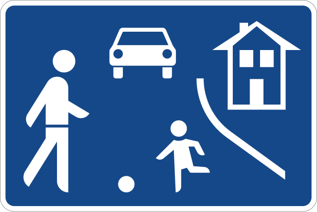
Deutsch: Zeichen 325.1 – Beginn eines verkehrsberuhigten Bereichs. Das Zeichen wurde als „Zeichen 325“ nach der Verordnung zur Änderung der StVO vom 21. Juli 1980 neu eingeführt. Die Nummernänderung von 325 zu 325.1 erfolgte zum 1.9.2009. Der korrekte digitale RAL-Farbton Signalblau (Farbcode: #154889) wird wiedergegeben.
English: Sign No. 325.1 – start of "traffic calming area"
Image taken from the de:Straßenverkehrsordnung (German Road Regulations) as published by the de:Bundesministerium für Verkehr, Bau- und Wohnungswesen (German Federal Ministry of Traffic, Building and Housing) at [1]. |
| Date | (erstes Hochladedatum) |
| Source | Own work |
| Author |
Andreas06; English: vectorized by Mediatus Deutsch: vektorisiert durch Mediatus |
| SVG development |
|
|
Do not upload new revisions over this file version without my explicit consent. Instead, use the possibility to upload a new version under a new name and tag it as a derivative or extract of this file. Mediatus |

Licensing[edit]
| This image is in the public domain according to German copyright law because it is part of a statute, ordinance, official decree or judgment (official work) issued by a German authority or court (§ 5 Abs.1 UrhG).
|
 |
| This road sign image is in the public domain according to German copyright law because it is part of the German Verkehrszeichenkatalog (Road Sign Catalogue), Straßenverkehrsordnung (Road Traffic Code) or other statues, ordinances or official decrees proclaimed in the Verkehrsblatt (Traffic Gazette) (§ 5 Abs. 1 UrhG).
|
 |
File history
Click on a date/time to view the file as it appeared at that time.
| Date/Time | Thumbnail | Dimensions | User | Comment | |
|---|---|---|---|---|---|
| current | 12:01, 12 December 2017 | | 732 × 489 (7 KB) | Mediatus (talk | contribs) | gef. |
| 19:17, 29 August 2017 |  | 732 × 488 (7 KB) | Mediatus (talk | contribs) | korrekter Rand | |
| 12:15, 15 August 2013 |  | 1,250 × 840 (9 KB) | Mediatus (talk | contribs) | korrekter digitaler RAL-Farbton Signalblau (Farbcode: #154889) | |
| 14:41, 29 July 2006 |  | 1,250 × 840 (8 KB) | Andreas 06 (talk | contribs) | {{German}} Zeichen 325 – Beginn eines verkehrsberuhigten Bereichs <br />{{English}} Sign No. 325 – start of tranquilised area Image taken from the de:Straßenverkehrsordnung (German Road Regulations) as published by the [[:de:Bundesministerium f |
You cannot overwrite this file.
File usage on Commons
The following 18 pages use this file:
- Historic road signs in Germany
- Road signs of Germany
- Commons:Files used on the AARoads Wiki/73
- Commons:Files used on the OpenStreetMap Wiki/30
- File:Zeichen 325.1.svg (file redirect)
- File:Zeichen 325.1 - Beginn eines verkehrsberuhigten Bereichs, StVO 2013.svg (file redirect)
- File:Zeichen 325.svg (file redirect)
- Category:Road signs in Magdeburg
- Category:Road signs in Wuppertal
- Category:Zeichen 325 in Hannover
- Category:Zeichen 325 in Osnabrück
- Category:Zeichen 325 in Wuppertal
File usage on other wikis
The following other wikis use this file:
- Usage on ar.wikipedia.org
- Usage on de.wikipedia.org
- Blau
- Straßenverkehrs-Ordnung (Deutschland)
- Vorfahrt
- Verkehrsberuhigter Bereich
- Parkverbot
- Spielstraße
- Diskussion:Spielstraße
- Schrittgeschwindigkeit
- Bildtafel der Verkehrszeichen in der Bundesrepublik Deutschland von 2013 bis 2017
- Benutzer:Klugerrabe
- Benutzer:Toytoy~dewiki/Vorfahrt (neu)
- Benutzer:Antonsusi/Verkehrszeichen
- Vergleich europäischer Verkehrszeichen
- Bildtafel der Verkehrszeichen in der Bundesrepublik Deutschland von 1992 bis 2013
- Liste der Straßen in Kressbronn am Bodensee
- Spielraum (Ort)
- Bildtafel der Verkehrszeichen in der Bundesrepublik Deutschland seit 2017
- Benutzer:Bert.Kilanowski/Testseite 3
- Liste der Straßen in Aachen-Mitte
- Benutzer:Bert.Kilanowski/Testseite 2
- Benutzer:Happy Discover/Werkstatt
- Benutzer:Dodowp/Straßen
- Wikipedia:Auskunft/Archiv/2023/Woche 26
- Usage on de.wikibooks.org
- Usage on de.wikivoyage.org
- Usage on en.wikipedia.org
- Usage on en.wikivoyage.org
- Usage on es.wikipedia.org
- Usage on es.wikibooks.org
- Usage on fa.wikipedia.org
- Usage on fi.wikipedia.org
- Usage on fr.wikipedia.org
- Usage on fy.wikipedia.org
- Usage on is.wikipedia.org
- Usage on it.wikipedia.org
- Usage on it.wikibooks.org
- Usage on ja.wikipedia.org
- Usage on mn.wikipedia.org
View more global usage of this file.