File:WW2 Holocaust Europe map-de.png
Jump to navigation
Jump to search
Size of this preview: 721 × 600 pixels. Other resolutions: 289 × 240 pixels | 577 × 480 pixels | 923 × 768 pixels | 1,231 × 1,024 pixels | 2,461 × 2,048 pixels | 2,729 × 2,271 pixels.
Original file (2,729 × 2,271 pixels, file size: 660 KB, MIME type: image/png)
Captions
Captions
Add a one-line explanation of what this file represents
Summary[edit]
| Description |
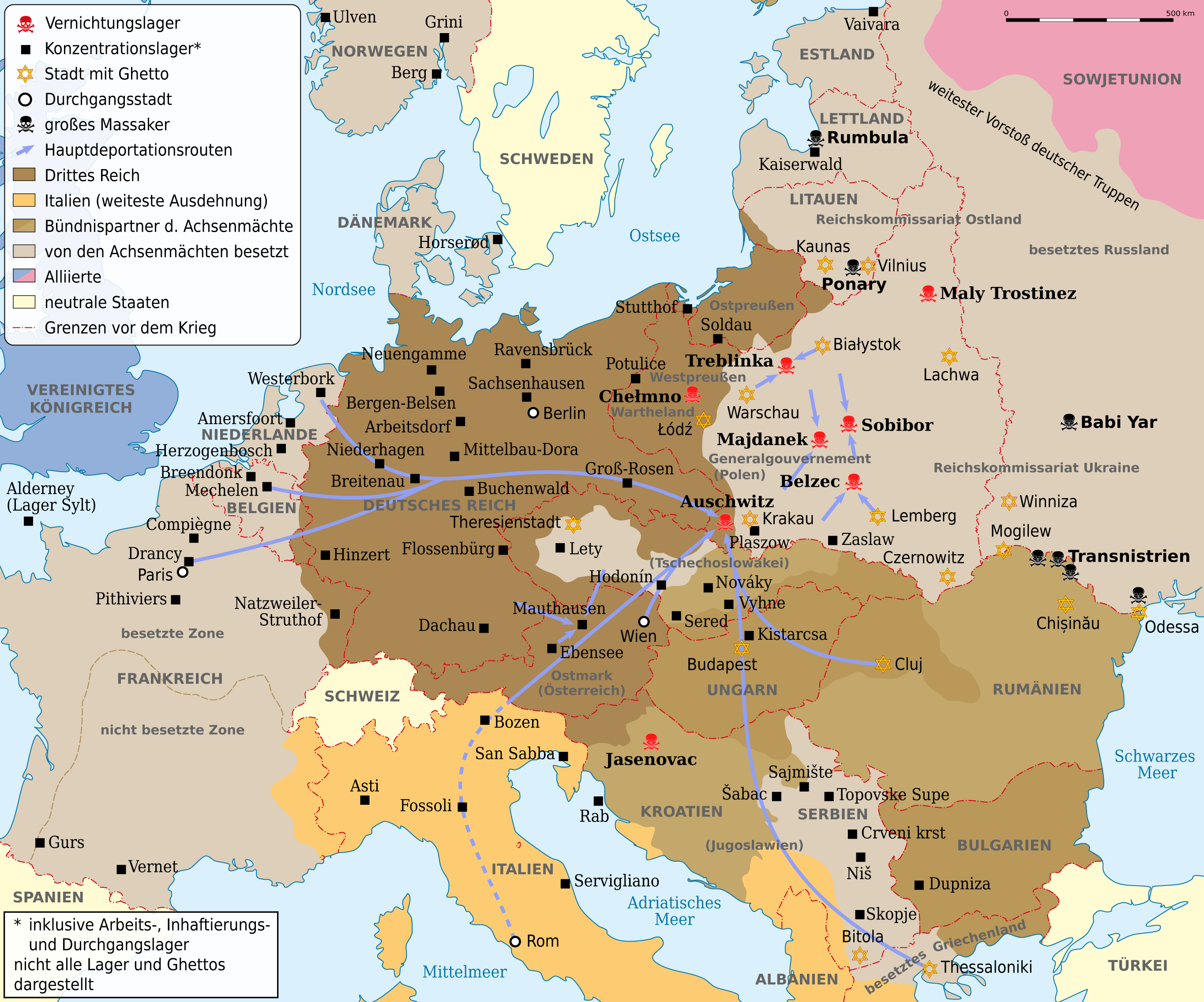
Deutsch: Karte der Vernichtungslager, der meisten großen Konzentrationslager (Arbeits-, Inhaftierungs- und Durchgangslager), der Hauptdeportationsrouten, Ghettos und Orten großer Massaker. Grenzen etwa 1942. Vor- und Nachkriegsstaatennamen in Klammern. English: Map of the extermination camps, most of the major concentration camps (labor, detention and transit camp), the main deportation routes, ghettos and places great massacre. Limits about the 1942nd Pre-and post-conflict states name in parentheses |
| Date | |
| Source |
This file was derived from: WW2 Holocaust Europe map-fr.svg |
| Author |
|
| This is a retouched picture, which means that it has been digitally altered from its original version. Modifications: translation. The original can be viewed here: WW2 Holocaust Europe map-fr.svg:
|
Licensing[edit]
I, the copyright holder of this work, hereby publish it under the following license:
| Copyleft: This work of art is free; you can redistribute it and/or modify it according to terms of the Free Art License. You will find a specimen of this license on the Copyleft Attitude site as well as on other sites. |
Original upload log[edit]
This image is a derivative work of the following images:
- File:WW2_Holocaust_Europe_map-fr.svg licensed with FAL
- 2011-09-28T13:32:55Z Sémhur 1310x1090 (502755 Bytes) Location of Varsovie, border between Poland and East Prussia
- 2009-05-11T16:52:07Z Sémhur 1310x1090 (607330 Bytes) {{Information |Description=Map of the Holocaust in Europe during World War II, 1939-1945. This map shows all extermination camps (or ''death camps''), most major concentration camps, labor camps, prison camps, ghettos, major
File history
Click on a date/time to view the file as it appeared at that time.
| Date/Time | Thumbnail | Dimensions | User | Comment | |
|---|---|---|---|---|---|
| current | 08:53, 1 May 2013 | | 2,729 × 2,271 (660 KB) | NordNordWest (talk | contribs) | c |
| 08:03, 14 September 2012 |  | 2,729 × 2,271 (660 KB) | NordNordWest (talk | contribs) | c | |
| 20:45, 13 September 2012 |  | 2,729 × 2,271 (654 KB) | NordNordWest (talk | contribs) | c | |
| 19:07, 12 September 2012 |  | 2,729 × 2,271 (660 KB) | NordNordWest (talk | contribs) | == {{int:filedesc}} == {{Information |Description={{de|Karte der Vernichtungslager, der meisten großen Konzentrationslager (Arbeits-, Inhaftierungs- und Durchgangslager), der Hauptdeportationsrouten, Ghettos und Orten großer Massaker. Grenzen etwa 19... |
You cannot overwrite this file.
File usage on Commons
The following 25 pages use this file:
- File:WW2-Holocaust-Europe-2007Borders.png
- File:WW2-Holocaust-Europe-2007Borders DE.png
- File:WW2-Holocaust-Europe-he.png
- File:WW2-Holocaust-Europe.png
- File:WW2-Holocaust-Europe DE.png
- File:WW2-Holocaust-Europe DE 2.png
- File:WW2-Holocaust-Europe blank.png
- File:WW2-Holocaust-Poland-ru.png
- File:WW2-Holocaust-Poland-ukr.jpg
- File:WW2-Holocaust-Poland.PNG
- File:WW2-Holocaust-Poland (Français).png
- File:WW2-Holocaust-Poland (without comment).png
- File:WW2-Holocaust-Poland big legend.PNG
- File:WW2-Zagłada-Żydów-Polska.png
- File:WW2 Holocaust Europe N-E map-fr.svg
- File:WW2 Holocaust Europe map-blank.svg
- File:WW2 Holocaust Europe map-es.svg
- File:WW2 Holocaust Europe map-fr.svg
- File:WW2 Holocaust Europe map-it.svg
- File:WW2 Holocaust Europe map-pt.svg
- File:WW2 Holocaust Europe map-zh-hans.svg
- File:WW2 Holocaust Poland map-fr.svg
- File:Холокост в Европе.png
- Template:Other versions/WW2 Holocaust Europe map
- Category:Nazi concentration camps
.png)
.png)
File usage on other wikis
The following other wikis use this file:
- Usage on ca.wikipedia.org
- Usage on de.wikipedia.org
- Deportation
- Holocaust
- Durchgangslager Fossoli
- Deutsche Besetzung Polens 1939–1945
- Konzentrationslager
- Durchgangslager Bozen
- Eichmannreferat
- Wikipedia:Kartenwerkstatt/Archiv/2012-09
- Deutsche Besetzung Frankreichs im Zweiten Weltkrieg
- Diskussion:Gesetz über das Institut des Nationalen Gedenkens – Kommission für die Verfolgung von Verbrechen gegen das Polnische Volk
- Usage on ga.wikipedia.org
- Usage on ksh.wikipedia.org
- Usage on no.wikipedia.org
- Usage on stq.wikipedia.org
- Usage on uk.wikipedia.org
- Usage on www.wikidata.org