File:Sv-map-de.png
Jump to navigation
Jump to search
No higher resolution available.
Sv-map-de.png (326 × 350 pixels, file size: 9 KB, MIME type: image/png)
Captions
Captions
Add a one-line explanation of what this file represents
| Description |
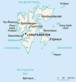
Deutsch: CIA Karte von Svalbard, übersetzt von de:Benutzer:Head
English: CIA map of Svalbard, translated by de:Benutzer:Head |
|||
| Source | United States Central Intelligence Agency's World Factbook | |||
| Author | CIA map, translated by de:Benutzer:Head | |||
| Permission (Reusing this file) |
|

File history
Click on a date/time to view the file as it appeared at that time.
| Date/Time | Thumbnail | Dimensions | User | Comment | |
|---|---|---|---|---|---|
| current | 22:05, 7 January 2021 | | 326 × 350 (9 KB) | Ras67 (talk | contribs) | frame removed |
| 19:12, 21 August 2006 |  | 329 × 355 (10 KB) | Frumpy (talk | contribs) | {{Information |Description= |Source= |Date= |Author=CIA map, translated by de:Benutzer:Head |Permission={{PD-USGov-CIA-WF}} |other_versions= }} Category:Maps of Svalbard |
You cannot overwrite this file.
File usage on Commons
The following 4 pages use this file:
File usage on other wikis
The following other wikis use this file:
- Usage on da.wikipedia.org
- Usage on de.wikipedia.org
- Usage on dsb.wikipedia.org
- Usage on en.wikipedia.org
- Usage on eo.wikipedia.org
- Usage on frr.wikipedia.org
- Usage on hsb.wikipedia.org
- Usage on nn.wikipedia.org
- Usage on rm.wikipedia.org
- Usage on zh-yue.wikipedia.org
- Usage on zh.wikipedia.org