File:Partition of India 1947 en.svg
Jump to navigation
Jump to search

Size of this PNG preview of this SVG file: 609 × 599 pixels. Other resolutions: 244 × 240 pixels | 488 × 480 pixels | 780 × 768 pixels | 1,041 × 1,024 pixels | 2,081 × 2,048 pixels | 1,189 × 1,170 pixels.
Original file (SVG file, nominally 1,189 × 1,170 pixels, file size: 724 KB)
Captions
Captions
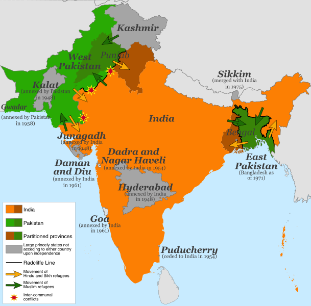
Map of the partition of India (1947). Note: Small princely states not acceding to either country upon independence are shown as integral parts of India and Pakistan.
Summary[edit]
| Description |
English: Map of the partition of India (1947). Note: Small princely states not acceding to either country upon independence are shown as integral parts of India and Pakistan. |
| Date | |
| Source |
This file was derived from: |
| Author | Own work |
| Other versions |
[]
|


.svg)


.svg)
Licensing[edit]
This file is licensed under the Creative Commons Attribution-Share Alike 4.0 International license.
- You are free:
- to share – to copy, distribute and transmit the work
- to remix – to adapt the work
- Under the following conditions:
- attribution – You must give appropriate credit, provide a link to the license, and indicate if changes were made. You may do so in any reasonable manner, but not in any way that suggests the licensor endorses you or your use.
- share alike – If you remix, transform, or build upon the material, you must distribute your contributions under the same or compatible license as the original.
File history
Click on a date/time to view the file as it appeared at that time.
| Date/Time | Thumbnail | Dimensions | User | Comment | |
|---|---|---|---|---|---|
| current | 13:15, 5 July 2017 | | 1,189 × 1,170 (724 KB) | RaviC (talk | contribs) | some rendering adjustments |
| 13:14, 5 July 2017 |  | 1,189 × 1,170 (717 KB) | RaviC (talk | contribs) | + Gwadar | |
| 02:57, 30 April 2017 |  | 1,189 × 1,170 (661 KB) | फ़िलप्रो (talk | contribs) | Kalat and Dadra and Nagar Haveli border width. | |
| 02:46, 30 April 2017 |  | 1,189 × 1,170 (648 KB) | फ़िलप्रो (talk | contribs) | Fixed Junagadh, location of Diu (Daman and Diu), and added Dadra and Nagar Haveli. | |
| 01:31, 30 April 2017 |  | 1,189 × 1,170 (643 KB) | फ़िलप्रो (talk | contribs) | Added labels for other annexed princely states. Fixed shape of Bengal and Punjab provinces as per their sizes in 1947. | |
| 12:17, 11 February 2017 |  | 1,189 × 1,170 (433 KB) | Superbenjamin (talk | contribs) | User created page with UploadWizard |
You cannot overwrite this file.
File usage on Commons
The following 31 pages use this file:
- Atlas of India
- Partition of British India
- File:Dispartigo de Barato 1947.svg
- File:Partage de l'Inde.svg
- File:Partition of India-ar.svg
- File:Partition of India-bn (1947).svg
- File:Partition of India-ce.svg
- File:Partition of India-en.svg
- File:Partition of India-es.svg
- File:Partition of India-fa.svg
- File:Partition of India-ms.svg
- File:Partition of India-ru.svg
- File:Partition of India-sd.svg
- File:Partition of India-ur.svg
- File:Partition of India.PNG
- File:Partition of India 1947-bn.svg
- File:Partition of India 1947-hi.svg
- File:Partition of India 1947-hu.svg
- File:Partition of India 1947-kn.svg
- File:Partition of India 1947-pa.svg
- File:Partition of India 1947 en.svg
- File:Partition of India 1947 es.svg
- File:Partition of India 1947 fr.svg
- File:Partition of India 1947 gu.svg
- File:Partition of India 1947 it.svg
- File:Partition of India 1947 mr.svg
- File:Partition of India he.png
- File:Partizione dell'India.svg
- File:Podzial indii.svg
- Template:Other versions/Partition of India 1947
- Category:Partition of India
File usage on other wikis
The following other wikis use this file:
- Usage on af.wikipedia.org
- Usage on als.wikipedia.org
- Usage on ast.wikipedia.org
- Usage on az.wikipedia.org
- Usage on bg.wikipedia.org
- Usage on ca.wikipedia.org
- Usage on da.wikipedia.org
- Usage on de.wikipedia.org
- Usage on de.wikiversity.org
- Usage on en.wikipedia.org
- Usage on es.wikipedia.org
- Usage on eu.wikipedia.org
- Usage on fi.wikipedia.org
- Usage on ga.wikipedia.org
- Usage on he.wikipedia.org
- Usage on hy.wikipedia.org
- Usage on id.wikipedia.org
- Usage on is.wikipedia.org
- Usage on ja.wikipedia.org
- Usage on ka.wikipedia.org
- Usage on ko.wikipedia.org
- Usage on lv.wikipedia.org
- Usage on ml.wikipedia.org
- Usage on mr.wikipedia.org
- Usage on nl.wikipedia.org
- Usage on nn.wikipedia.org
- Usage on nn.wikiquote.org
- Usage on no.wikipedia.org
- Usage on pnb.wikipedia.org
- Usage on ps.wikipedia.org
View more global usage of this file.