File:North Sea map-de.png
Jump to navigation
Jump to search

Size of this preview: 477 × 599 pixels. Other resolutions: 191 × 240 pixels | 382 × 480 pixels | 612 × 768 pixels | 815 × 1,024 pixels | 2,472 × 3,104 pixels.
Original file (2,472 × 3,104 pixels, file size: 4.03 MB, MIME type: image/png)
Captions
Captions
Add a one-line explanation of what this file represents
Summary[edit]
| Description |
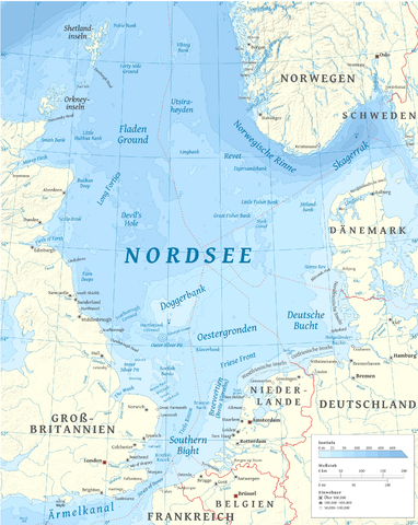
English: Map of the North Sea — in northern Europe. |
| Date | |
| Source |
This file was derived from: North Sea map-en.png: |
| Author | Halava |
| Other versions |
  |
| This is a retouched picture, which means that it has been digitally altered from its original version. Modifications: Retusche (Ergänzung fehlender Bildteile); Übersetzung ins Deutsche. Modifications made by MagentaGreen.
|
Licensing[edit]
I, the copyright holder of this work, hereby publish it under the following licenses:
This file is licensed under the Creative Commons Attribution-Share Alike 3.0 Unported license.
- You are free:
- to share – to copy, distribute and transmit the work
- to remix – to adapt the work
- Under the following conditions:
- attribution – You must give appropriate credit, provide a link to the license, and indicate if changes were made. You may do so in any reasonable manner, but not in any way that suggests the licensor endorses you or your use.
- share alike – If you remix, transform, or build upon the material, you must distribute your contributions under the same or compatible license as the original.

|
Permission is granted to copy, distribute and/or modify this document under the terms of the GNU Free Documentation License, Version 1.2 or any later version published by the Free Software Foundation; with no Invariant Sections, no Front-Cover Texts, and no Back-Cover Texts. A copy of the license is included in the section entitled GNU Free Documentation License. |
You may select the license of your choice.
File history
Click on a date/time to view the file as it appeared at that time.
| Date/Time | Thumbnail | Dimensions | User | Comment | |
|---|---|---|---|---|---|
| current | 06:04, 22 May 2016 | | 2,472 × 3,104 (4.03 MB) | Chumwa (talk | contribs) | kleinere Ergänzungen |
| 22:30, 5 May 2016 |  | 2,475 × 3,100 (4.33 MB) | MagentaGreen (talk | contribs) | 80:20 Prinzip | |
| 20:19, 5 May 2016 |  | 2,475 × 3,100 (4.33 MB) | MagentaGreen (talk | contribs) | Weitere Korrekturen | |
| 15:56, 5 May 2016 |  | 2,475 × 3,100 (4.33 MB) | MagentaGreen (talk | contribs) | Ärmelkanal statt Kanal; kleinere Retuschen. | |
| 14:25, 5 May 2016 |  | 2,475 × 3,100 (4.33 MB) | MagentaGreen (talk | contribs) | == {{int:filedesc}} == {{Information |Description={{de|1=Karte der '''Nordsee''' — in Nordeuropa.}}{{en|1=Map of the '''North Sea''' — in northern Europe.}} |Source={{Derived from|North Sea map-en.png|display=50}} '''Typeface:'... |
You cannot overwrite this file.
File usage on Commons
The following 5 pages use this file:
File usage on other wikis
The following other wikis use this file:
- Usage on de.wikipedia.org
- Usage on de.wikivoyage.org
- Usage on frr.wikipedia.org
- Usage on fr.wiktionary.org
- Usage on hu.wikipedia.org
- Usage on nl.wiktionary.org
- Usage on www.wikidata.org