File:Nordsee Wirtschaftszonen.png
Jump to navigation
Jump to search

Size of this preview: 515 × 599 pixels. Other resolutions: 206 × 240 pixels | 619 × 720 pixels.
Original file (619 × 720 pixels, file size: 342 KB, MIME type: image/png)
Captions
Captions
Add a one-line explanation of what this file represents
Summary[edit]
| Description | |||||||||
| Date | |||||||||
| Source |
(Original text: selbst erstellt auf Grundlage einer Wiki Grafik (anscheinend von File:Mer du Nord-vierge.png)) borders based on [.. Template/Data-Source? ..] |
||||||||
| Author |
|
||||||||
| Other versions |
|


|
This image could be re-created using vector graphics as an SVG file. This has several advantages; see Commons:Media for cleanup for more information. If an SVG form of this image is available, please upload it and afterwards replace this template with
{{vector version available|new image name}}.
It is recommended to name the SVG file “Nordsee Wirtschaftszonen.svg”—then the template Vector version available (or Vva) does not need the new image name parameter. |
| This is a retouched picture, which means that it has been digitally altered from its original version. Modifications: Grenzen. The original can be viewed here: Mer du Nord-vierge.png:
|
I, the copyright holder of this work, hereby publish it under the following licenses:
| This file is licensed under the Creative Commons Attribution-Share Alike 3.0 Unported license. | ||
| ||
| This licensing tag was added to this file as part of the GFDL licensing update. |

|
Permission is granted to copy, distribute and/or modify this document under the terms of the GNU Free Documentation License, Version 1.2 or any later version published by the Free Software Foundation; with no Invariant Sections, no Front-Cover Texts, and no Back-Cover Texts. A copy of the license is included in the section entitled GNU Free Documentation License. |
You may select the license of your choice.
Original upload log[edit]
The original description page was here. All following user names refer to de.wikipedia.
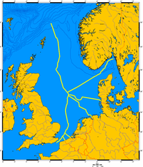
- 2009-11-05 19:28 FalkOberdorf 619×720× (350312 bytes) {{Information |Beschreibung = Wirtschaftszonen in der Nordsee |Quelle = selbst erstellt auf Grundlage einer Wiki Grafik |Urheber = Falk Oberdorf, Osterstr. 8, 32312 Lübbecke |Datum = 06.11.2009 |Genehmigung = ~~~~ |Andere Versionen = |Anmerkungen = }}
This image is a derivative work of the following images:
- File:Mer_du_Nord-vierge.png licensed with Cc-by-sa-3.0-migrated, GFDL
- 2005-06-19T19:40:54Z Idarvol 1076x1217 (98382 Bytes) {{Français}} Carte de la mer du Nord, Skagerrak et Kattegat vierge, lignes de niveau à 200 m. Projection de Mercator Données de 2005 ''Fond de carte issu de [http://www.aquarius.geomar.de www.aquarius.geomar.de] Sous l
File history
Click on a date/time to view the file as it appeared at that time.
| Date/Time | Thumbnail | Dimensions | User | Comment | |
|---|---|---|---|---|---|
| current | 22:27, 26 March 2011 | | 619 × 720 (342 KB) | File Upload Bot (Magnus Manske) (talk | contribs) | {{BotMoveToCommons|de.wikipedia|year={{subst:CURRENTYEAR}}|month={{subst:CURRENTMONTHNAME}}|day={{subst:CURRENTDAY}}}} {{Information |Description={{de|Wirtschaftszonen in der de:Nordsee}} |Source=Transferred from [http://de.wikipedia.org de.wikiped |
You cannot overwrite this file.
File usage on Commons
The following page uses this file:
File usage on other wikis
The following other wikis use this file:
- Usage on ar.wikipedia.org
- Usage on bs.wikipedia.org
- Usage on de.wikipedia.org
- Nordsee
- Deutsche Gesellschaft zur Rettung Schiffbrüchiger
- Ausschließliche Wirtschaftszone
- Rescue Coordination Centre
- Entenschnabel (Nordsee)
- Diskussion:Deutschland/Archiv/2
- Generaldirektion Wasserstraßen und Schifffahrt
- Seegrenzdisput in der Nordsee zwischen Deutschland, den Niederlanden und Dänemark
- Usage on hu.wikipedia.org
- Usage on sh.wikipedia.org
- Usage on sr.wikipedia.org