File:Litauen-regional.png

Original file (3,218 × 2,290 pixels, file size: 153 KB, MIME type: image/png)
Captions
Captions

|
This locator map image could be re-created using vector graphics as an SVG file. This has several advantages; see Commons:Media for cleanup for more information. If an SVG form of this image is available, please upload it and afterwards replace this template with
{{vector version available|new image name}}.
It is recommended to name the SVG file “Litauen-regional.svg”—then the template Vector version available (or Vva) does not need the new image name parameter. |
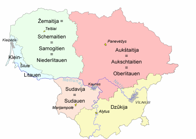
Ethnographic regions of Lithuania within borders of modern Lithuania. Based on map drawn and approved by Council for the Protection of Ethnic Culture (Etninės kultūros globos taryba), a council under Seimas, Lithuanian parliament.
Ethnographic regions of Lithuania are not based on political history or administrative divisions. The regions are based on cultural differences of ordinary people living there.
Names used in German literature, added by Ulamm 10:12, 11 May 2008 (UTC)
Legend:
- Light blue - Lithuania Minor (Mažoji Lietuva)
- Light Green - Samogitia (Žemaitija)
- Pink - Highland (Aukštaitija)
- Yellow - Dainava (Dzūkija)
- Light brown - Sudovia (Suvalkija)
- Yellow cities - unofficial capitals of each region
- Vilnius - capital of Lithuania
Basic version = Image:Liet-etno-regionai.png
| I, the copyright holder of this work, release this work into the public domain. This applies worldwide. In some countries this may not be legally possible; if so: I grant anyone the right to use this work for any purpose, without any conditions, unless such conditions are required by law. |
File history
Click on a date/time to view the file as it appeared at that time.
| Date/Time | Thumbnail | Dimensions | User | Comment | |
|---|---|---|---|---|---|
| current | 20:49, 11 May 2008 | | 3,218 × 2,290 (153 KB) | Ulamm (talk | contribs) | |
| 10:16, 11 May 2008 |  | 3,218 × 2,290 (154 KB) | Ulamm (talk | contribs) | ||
| 10:12, 11 May 2008 |  | 3,218 × 2,290 (154 KB) | Ulamm (talk | contribs) | Ethnographic regions of Lithuania within borders of modern Lithuania. Based on [http://www3.lrs.lt/owa-bin/owarepl/inter/owa/U0123191.jpg map] drawn and approved by [http://www3.lrs.lt/pls/inter/w5_show?p_r=877&p_d=35196&p_k=2 Council for the Protection o |
You cannot overwrite this file.
File usage on Commons
There are no pages that use this file.
File usage on other wikis
The following other wikis use this file:
- Usage on bs.wikipedia.org
- Usage on de.wikipedia.org
- Usage on de.wikivoyage.org
- Usage on lt.wikipedia.org
- Usage on lt.wikibooks.org
- Usage on ru.wikipedia.org
- Usage on sv.wikipedia.org