File:Kaschmir umstrittene Gebiete.svg
Jump to navigation
Jump to search

Size of this PNG preview of this SVG file: 793 × 600 pixels. Other resolutions: 317 × 240 pixels | 635 × 480 pixels | 1,016 × 768 pixels | 1,280 × 968 pixels | 2,560 × 1,936 pixels | 862 × 652 pixels.
Original file (SVG file, nominally 862 × 652 pixels, file size: 213 KB)
Captions
Captions
Add a one-line explanation of what this file represents
Summary[edit]
| Description |
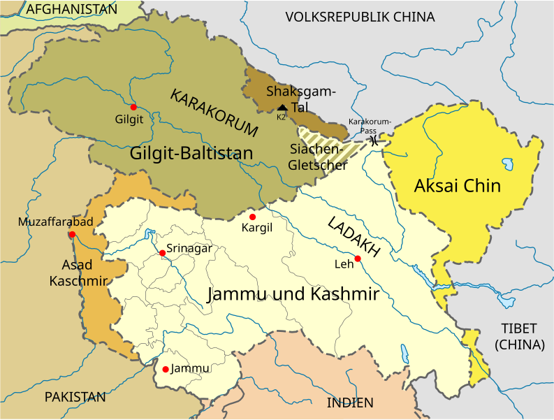
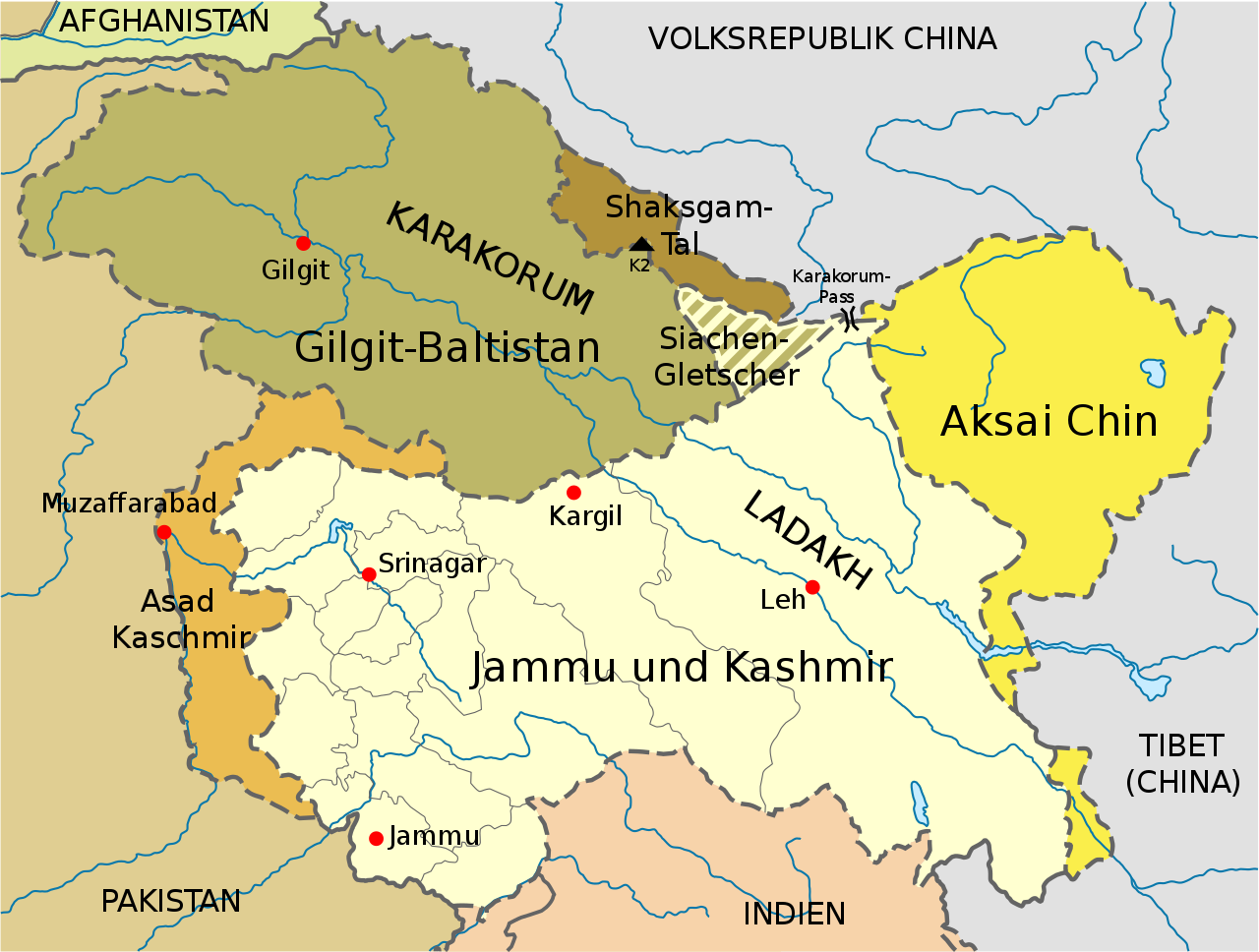
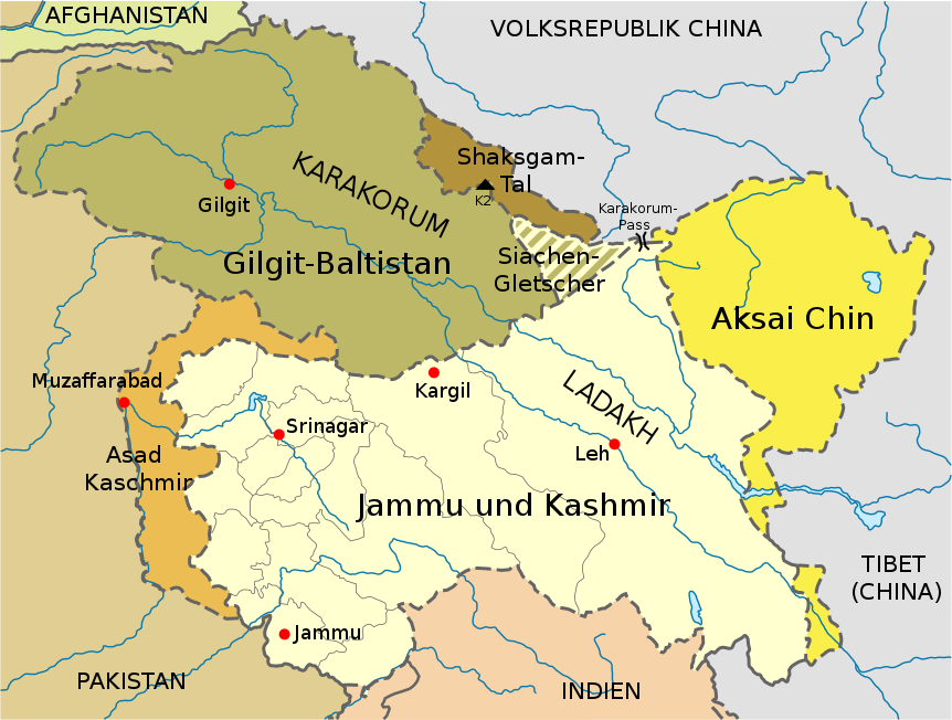
Deutsch: Karte von Jammu und Kaschmir.
Unter indischer Kontrolle (Bundesstaat Jammu und Kashmir).
Unter pakistanischer Kontrolle (Asad Kaschmir).
Unter pakistanischer Kontrolle (Gilgit-Baltistan).
Unter chinesischer Kontrolle.
Shaksgam-Tal (von Pakistan an China abgetreten, von Indien nicht anerkannt). English: Map of Jammu und Kaschmir.
Indian state of Jammu und Kashmir.
Pakistani territory of Azad Kashmir.
Gilgit-Baltistan (under Pakistani control).
Under control of the People's Republic of China.
Shaksgam valley (ceded to China by Pakistan, not recognized by India). |
|||
| Date | ||||
| Source |
This file was derived from: |
|||
| Author | Furfur | |||
| Permission (Reusing this file) |
I, the copyright holder of this work, hereby publish it under the following licenses:
This file is licensed under the Creative Commons Attribution-Share Alike 4.0 International license.
You may select the license of your choice. |
|||
| Other versions |
|
|||
| SVG development |


File history
Click on a date/time to view the file as it appeared at that time.
| Date/Time | Thumbnail | Dimensions | User | Comment | |
|---|---|---|---|---|---|
| current | 23:01, 5 September 2015 | | 862 × 652 (213 KB) | Furfur (talk | contribs) | Detail |
| 12:23, 30 August 2015 |  | 862 × 652 (213 KB) | Furfur (talk | contribs) | typos | |
| 12:12, 30 August 2015 |  | 862 × 652 (213 KB) | Furfur (talk | contribs) | Beschriftungen etwas kleiner | |
| 12:10, 30 August 2015 |  | 862 × 652 (213 KB) | Furfur (talk | contribs) | == {{int:filedesc}} == {{Information |Description={{de|1=Karte von Jammu und Kaschmir. {{legend|#FFFFD0|Unter indischer Kontrolle (Bundesstaat Jammu und Kashmir).}} {{legend|#EBBD52|Unter pakistanischer Kontrolle (Azad Kashmir).}} {{legend|#BDB768|Unte... |
You cannot overwrite this file.
File usage on Commons
The following 4 pages use this file:
File usage on other wikis
The following other wikis use this file:
- Usage on af.wikipedia.org
- Usage on ca.wikipedia.org
- Usage on ceb.wikipedia.org
- Usage on de.wikipedia.org
- Kaschmir
- 1. Januar
- 1947
- 2. Mai
- Kaschmir-Konflikt
- Jammu und Kashmir (Bundesstaat)
- Kargil-Krieg
- Geschichte Ladakhs
- Pakistan
- Mohammed Abdullah
- Karakorumpass
- Shaksgam-Tal
- Siachen-Konflikt
- Shaksgam
- Parlamentswahl in Indien 1999
- Wikipedia Diskussion:Hauptseite/Archiv/2017/November
- Indisch-pakistanische Beziehungen
- Usage on es.wikipedia.org
- Usage on eu.wikipedia.org
- Usage on he.wikivoyage.org
- Usage on lb.wikipedia.org
- Usage on pt.wikipedia.org
- Usage on ru.wikipedia.org
- Usage on sl.wikipedia.org
- Usage on www.wikidata.org