File:Karte der Stadtbahn Stuttgart und des O-Bus Esslingen.png
Jump to navigation
Jump to search
Size of this preview: 620 × 599 pixels. Other resolutions: 248 × 240 pixels | 496 × 480 pixels | 794 × 768 pixels | 1,059 × 1,024 pixels | 2,118 × 2,048 pixels | 2,806 × 2,713 pixels.
Original file (2,806 × 2,713 pixels, file size: 7.15 MB, MIME type: image/png)
Captions
Captions
Add a one-line explanation of what this file represents

|
This transport map image could be re-created using vector graphics as an SVG file. This has several advantages; see Commons:Media for cleanup for more information. If an SVG form of this image is available, please upload it and afterwards replace this template with
{{vector version available|new image name}}.
It is recommended to name the SVG file “Karte der Stadtbahn Stuttgart und des O-Bus Esslingen.svg”—then the template Vector version available (or Vva) does not need the new image name parameter. |
Summary[edit]
| Description |
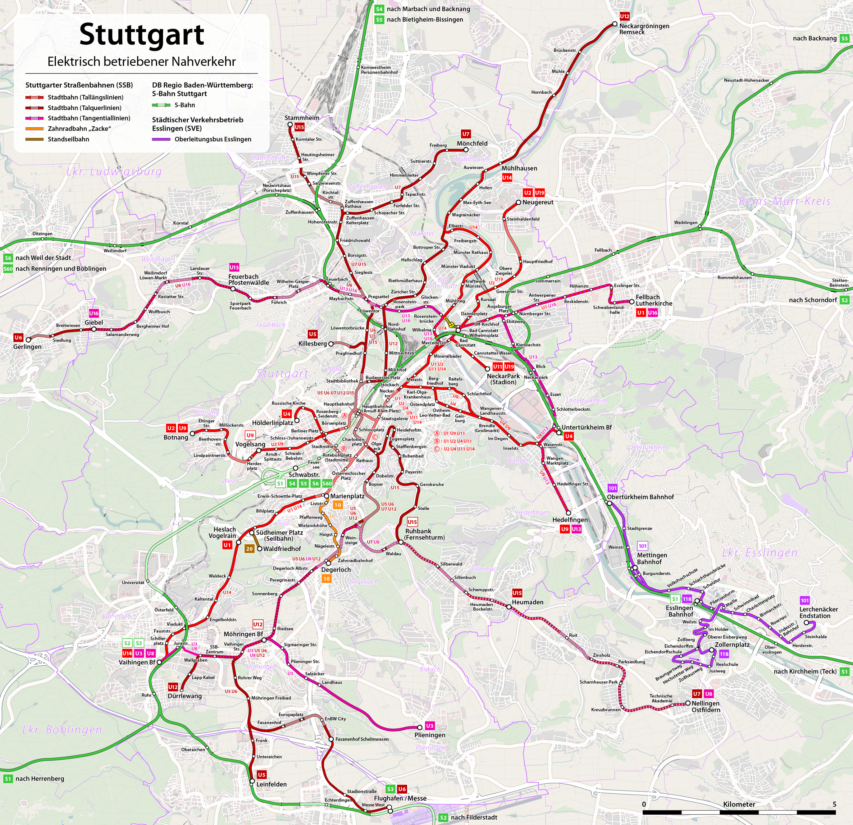
Deutsch: Karte: Netzplan der Stadtbahn Stuttgart und des Oberleitungsbus Esslingen 2010
English: Map of the Stuttgart tramway system and the Esslingen trolleybus network 2010
Français : Plan des réseaux du tramway de Stuttgart et du trolleybus d'Esslingen 2010 |
|||
| Date | see file history | |||
| Source | Own work, using OpenStreetMap data for the background | |||
| Author | Maximilian Dörrbecker (Chumwa) | |||
| Permission (Reusing this file) |
All OpenStreetMap data and maps are Creative Commons "CC-BY-SA 2.0" licensed This file is licensed under the Creative Commons Attribution-Share Alike 2.0 Generic license.
|
|||
| Other versions |
|
| This work contains information from OpenStreetMap, which is made available under the Open Database License (ODbL).
The ODbL does not require any particular license for maps produced from ODbL data. Prior to 1 August 2020, map tiles produced by the OpenStreetMap Foundation were licensed under the CC-BY-SA-2.0 license. Maps produced by other people may be subject to other licences. |
File history
Click on a date/time to view the file as it appeared at that time.
| Date/Time | Thumbnail | Dimensions | User | Comment | |
|---|---|---|---|---|---|
| current | 01:07, 25 December 2023 | | 2,806 × 2,713 (7.15 MB) | Bigbossfarin (talk | contribs) | U1 und U14 Tausch |
| 21:53, 10 December 2023 |  | 2,806 × 2,713 (8.22 MB) | Bigbossfarin (talk | contribs) | Schlechte Retusche für Netz 2024 | |
| 14:23, 27 November 2022 |  | 2,806 × 2,713 (6.83 MB) | Bigbossfarin (talk | contribs) | Schraffierung | |
| 00:48, 22 November 2022 |  | 2,806 × 2,713 (8.23 MB) | Bigbossfarin (talk | contribs) | Retusche | |
| 15:28, 21 November 2022 |  | 2,806 × 2,713 (7.93 MB) | Bigbossfarin (talk | contribs) | Versuch Aktualisierung Flughafen | |
| 00:23, 19 January 2019 |  | 2,993 × 2,894 (6.16 MB) | Chumwa (talk | contribs) | Umbenennung Eckartshaldenweg in Pragfriedhof | |
| 09:42, 15 December 2018 |  | 2,993 × 2,894 (6.16 MB) | Chumwa (talk | contribs) | Fahrplanwechsel 12.2018 mit Änderungen U13 und U16 | |
| 20:21, 11 December 2017 |  | 2,993 × 2,894 (6.15 MB) | Chumwa (talk | contribs) | S-Bahn-Halt Nürnberger Straße nachgetragen | |
| 21:59, 10 December 2017 |  | 2,993 × 2,894 (6.15 MB) | Chumwa (talk | contribs) | Haltestelle Budapester Platz nachgetragen | |
| 15:57, 10 December 2017 |  | 2,993 × 2,894 (6.15 MB) | Chumwa (talk | contribs) | Haltestellenumbenennungen nachgezogen |
You cannot overwrite this file.
File usage on Commons
The following 46 pages use this file:
- Top 200 transport map images that should use vector graphics
- User:Chumwa/Gallery
- User:Chumwa/OgreBot/Potential transport maps/2016 August 1-10
- User:Chumwa/OgreBot/Potential transport maps/2016 May 11-20
- User:Chumwa/OgreBot/Potential transport maps/2017 December 1-10
- User:Chumwa/OgreBot/Potential transport maps/2017 December 11-20
- User:Chumwa/OgreBot/Potential transport maps/2017 March 1-10
- User:Chumwa/OgreBot/Potential transport maps/2017 October 21-31
- User:Chumwa/OgreBot/Potential transport maps/2018 December 11-20
- User:Chumwa/OgreBot/Potential transport maps/2019 January 11-20
- User:Chumwa/OgreBot/Public transport information/2016 August 1-10
- User:Chumwa/OgreBot/Public transport information/2016 May 11-20
- User:Chumwa/OgreBot/Public transport information/2017 December 1-10
- User:Chumwa/OgreBot/Public transport information/2017 December 11-20
- User:Chumwa/OgreBot/Public transport information/2017 March 1-10
- User:Chumwa/OgreBot/Public transport information/2017 October 21-31
- User:Chumwa/OgreBot/Public transport information/2018 December 11-20
- User:Chumwa/OgreBot/Public transport information/2019 January 11-20
- User:Chumwa/OgreBot/Public transport information/2022 November 21-30
- User:Chumwa/OgreBot/Public transport information/2023 December 1-10
- User:Chumwa/OgreBot/Public transport information/2023 December 21-31
- User:Chumwa/OgreBot/Transport Maps/2016 August 1-10
- User:Chumwa/OgreBot/Transport Maps/2016 May 11-20
- User:Chumwa/OgreBot/Transport Maps/2017 December 1-10
- User:Chumwa/OgreBot/Transport Maps/2017 December 11-20
- User:Chumwa/OgreBot/Transport Maps/2017 March 1-10
- User:Chumwa/OgreBot/Transport Maps/2017 October 21-31
- User:Chumwa/OgreBot/Transport Maps/2018 December 11-20
- User:Chumwa/OgreBot/Transport Maps/2019 January 11-20
- User:Chumwa/OgreBot/Transport Maps/2022 November 21-30
- User:Chumwa/OgreBot/Transport Maps/2023 December 1-10
- User:Chumwa/OgreBot/Transport Maps/2023 December 21-31
- User:Chumwa/OgreBot/Travel and communication maps/2016 August 1-10
- User:Chumwa/OgreBot/Travel and communication maps/2016 May 11-20
- User:Chumwa/OgreBot/Travel and communication maps/2017 December 1-10
- User:Chumwa/OgreBot/Travel and communication maps/2017 December 11-20
- User:Chumwa/OgreBot/Travel and communication maps/2017 March 1-10
- User:Chumwa/OgreBot/Travel and communication maps/2017 October 21-31
- User:Chumwa/OgreBot/Travel and communication maps/2018 December 11-20
- User:Chumwa/OgreBot/Travel and communication maps/2019 January 11-20
- User:Clic/Nahverkehr in Deutschland/2019 January 11-20
- User:Clic/Nahverkehr in Deutschland/2022 November 21-30
- User:Nordlicht8/Rail Germany/2016 August 1-10
- User:Nordlicht8/Rail Germany/2016 May 11-20
- User:Triplec85-DE-BW-RPS-Landkreise-new-files/Landkreis Esslingen/2023 December
- Category:Trams in Stuttgart
File usage on other wikis
The following other wikis use this file:
- Usage on de.wikipedia.org
- Stuttgart
- Stuttgarter Straßenbahnen
- Stadtbahn Stuttgart
- Benutzer:Chumwa
- Wikipedia:Kartenwerkstatt/Kartenwünsche
- Benutzer Diskussion:Chumwa/Archiv/2013/3. Quartal
- Wikipedia:Kartenwerkstatt/Karte des Tages/Galerie
- Benutzer:Chumwa/SomeOfMyFiles
- Wikipedia:Kartenwerkstatt/Archiv/2017-10
- Benutzer Diskussion:Chumwa/Archiv/2017/4. Quartal
- Liste der Haltestellen der Stadtbahn Stuttgart
- Wikipedia:Kartenwerkstatt/Archiv/2018-12
- Benutzer Diskussion:Chumwa/Archiv/2022/4. Quartal
- Wikipedia:Kartenwerkstatt/Archiv/2022-11
- Usage on en.wikipedia.org
- Usage on en.wikivoyage.org
- Usage on eo.wikipedia.org
- Usage on es.wikipedia.org
- Usage on fa.wikipedia.org
- Usage on fr.wikipedia.org
- Usage on he.wikivoyage.org
- Usage on hu.wikipedia.org
- Usage on it.wikipedia.org
- Usage on ja.wikipedia.org
- Usage on ka.wikipedia.org
- Usage on lmo.wikipedia.org
- Usage on nl.wikipedia.org
- Usage on no.wikipedia.org
- Usage on pl.wikipedia.org
- Usage on pl.wikivoyage.org
- Usage on ru.wikipedia.org
- Usage on sh.wikipedia.org
- Usage on sr.wikipedia.org
- Usage on sv.wikipedia.org
- Usage on tg.wikipedia.org
- Usage on uk.wikipedia.org
- Usage on www.wikidata.org
- Usage on zh.wikipedia.org