File:Indo-Aryan language map.svg
Jump to navigation
Jump to search

Size of this PNG preview of this SVG file: 595 × 600 pixels. Other resolutions: 238 × 240 pixels | 476 × 480 pixels | 762 × 768 pixels | 1,016 × 1,024 pixels | 2,032 × 2,048 pixels | 1,617 × 1,630 pixels.
Original file (SVG file, nominally 1,617 × 1,630 pixels, file size: 1.78 MB)
Captions
Captions
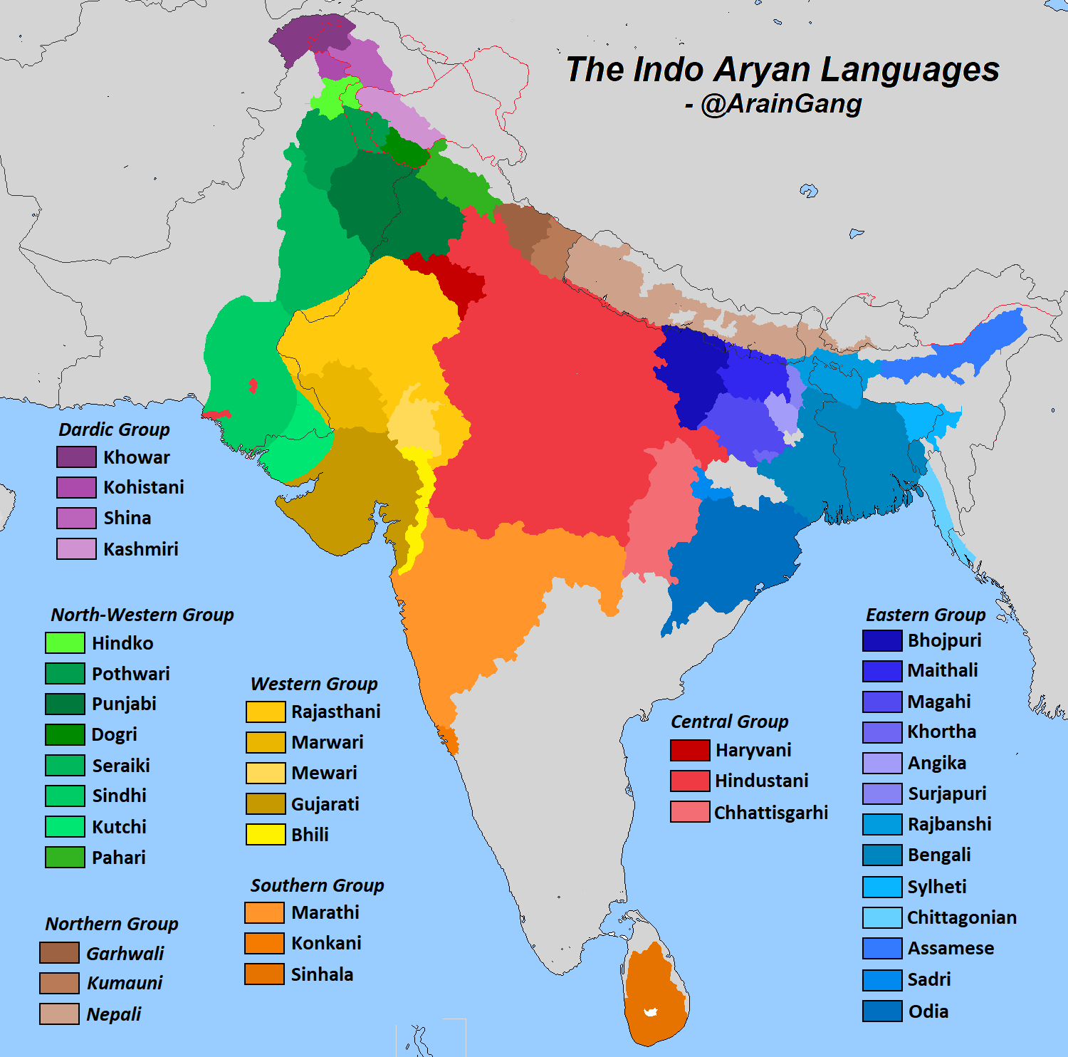
Map of major Indo-Aryan languages
Have https://miro.medium.com/v2/1*HPILgvUumtaePBhkrEaufA.png
Summary[edit]
| Description |
English: Map of major Indo-Aryan languages and language groups. Colors indicate the branches - yellow is Eastern, purple is Dardic, blue is Northwestern, red is Southern, green is Western, brown is Northern and orange is Central. Data is from "The Indo Aryan Languages" as well as census data and previous linguistic maps.
Pashai
Khowar
Shina
Kohistani
Kashmiri
Punjabi
Sindhi
Rajasthani
Gujarati
Khandeshi
Bhili
Western Pahari
Central Pahari
Nepali
Western Hindi
Eastern Hindi
Bengali-Assamese
Bihari
Odia
Halbi
Marathi-Konkani
Sinhala
Maldivan |
| Date | |
| Source | Derivative of File:India location map.svg |
| Author | Own work based on Uwe Dedering |
Licensing[edit]
This file is licensed under the Creative Commons Attribution-Share Alike 3.0 Unported license.
- You are free:
- to share – to copy, distribute and transmit the work
- to remix – to adapt the work
- Under the following conditions:
- attribution – You must give appropriate credit, provide a link to the license, and indicate if changes were made. You may do so in any reasonable manner, but not in any way that suggests the licensor endorses you or your use.
- share alike – If you remix, transform, or build upon the material, you must distribute your contributions under the same or compatible license as the original.
File history
Click on a date/time to view the file as it appeared at that time.
| Date/Time | Thumbnail | Dimensions | User | Comment | |
|---|---|---|---|---|---|
| current | 14:38, 3 June 2023 | | 1,617 × 1,630 (1.78 MB) | Chaipau (talk | contribs) | Reverted to version as of 05:17, 31 May 2023 (UTC) |
| 17:18, 2 June 2023 |  | 1,500 × 1,615 (2.1 MB) | Anonymous918191 (talk | contribs) | Reverted to version as of 13:03, 25 May 2023 (UTC) | |
| 05:17, 31 May 2023 |  | 1,617 × 1,630 (1.78 MB) | Divotdefer (talk | contribs) | Reverted to version as of 17:59, 23 December 2021 (UTC): don't fix something that aint broke | |
| 13:03, 25 May 2023 |  | 1,500 × 1,615 (2.1 MB) | Anonymous918191 (talk | contribs) | Reverted to version as of 03:52, 24 November 2020 (UTC) | |
| 17:59, 23 December 2021 |  | 1,617 × 1,630 (1.78 MB) | C1MM (talk | contribs) | Added shading to indicate transitional varieties | |
| 09:36, 17 September 2021 |  | 500 × 500 (1.64 MB) | Amritsvāraya (talk | contribs) | fixed error | |
| 09:22, 17 September 2021 |  | 1,894 × 1,705 (1.64 MB) | Amritsvāraya (talk | contribs) | corrected the Sinhala area from the map "https://en.wikipedia.org/wiki/Demographics_of_Sri_Lanka#/media/File:Sri_Lanka_-_Ethnicity_2012.png" | |
| 04:59, 4 April 2021 |  | 1,548 × 1,635 (1.63 MB) | C1MM (talk | contribs) | Corrected as per edit request, next time please use the talk page | |
| 07:10, 3 April 2021 |  | 1,500 × 1,615 (2.1 MB) | Mikeanand (talk | contribs) | Reverted to version as of 03:52, 24 November 2020 (UTC) As per previous edit summary | |
| 07:08, 3 April 2021 |  | 1,548 × 1,635 (1.64 MB) | Mikeanand (talk | contribs) | Reverted to version as of 16:33, 6 March 2021 (UTC) Although Surjapuri is spoken in parts of Purnia division, the area is still Maithili majority. |
You cannot overwrite this file.
File usage on Commons
The following 7 pages use this file:
- Atlas of India
- User:Chumwa/OgreBot/Travel and communication maps/2021 April 1-10
- User:Chumwa/OgreBot/Travel and communication maps/2021 December 21-31
- User:Chumwa/OgreBot/Travel and communication maps/2021 March 1-10
- User:Chumwa/OgreBot/Travel and communication maps/2021 September 11-20
- User:Chumwa/OgreBot/Travel and communication maps/2023 June 1-10
- User:Chumwa/OgreBot/Travel and communication maps/2023 May 21-31
File usage on other wikis
The following other wikis use this file:
- Usage on anp.wikipedia.org
- Usage on ar.wikipedia.org
- Usage on az.wikipedia.org
- Usage on bcl.wikipedia.org
- Usage on bh.wikipedia.org
- Usage on bn.wikipedia.org
- Usage on bs.wikipedia.org
- Usage on ceb.wikipedia.org
- Usage on de.wikipedia.org
- Usage on en.wikipedia.org
- Indo-Aryan languages
- Bhojpuri language
- List of Indo-European languages
- Indo-Aryan peoples
- Bishnupriya Manipuri
- Western Hindi languages
- Geography
- Eastern Indo-Aryan languages
- Eastern Hindi languages
- User:DrHäxer
- Chorochromatic map
- Template:User IA languages
- Wikipedia:Userboxes/Language/Family
- User:WikipedianUser12
- Technical geography
- User:Koustav Chatterjee
- User:Benipal hardarshan/FNF-ta
- User:Benipal hardarshan/FNF-pa
- Qualitative geography
- Template:User Indian Aryan
- User:OrdinaryGiraffe/Books/Vital/L2/A
- User:Pharaoh496/Userboxes
- Usage on fr.wikipedia.org
- Usage on gom.wikipedia.org
- Usage on it.wikipedia.org
- Usage on ko.wikipedia.org
- Usage on mr.wikipedia.org
- Usage on ne.wikipedia.org
- Usage on pnb.wikipedia.org
- Usage on sat.wikipedia.org
- Usage on sa.wikipedia.org
View more global usage of this file.