File:Geomap Germany.png

Original file (2,495 × 4,577 pixels, file size: 618 KB, MIME type: image/png)
Captions
Captions
Summary[edit]
| Description |
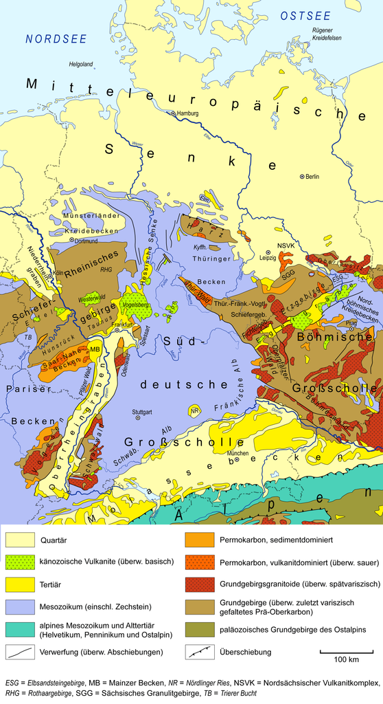
English: Simplified geological map of Germany and adjacent areas, based on Henningsen & Katzung (2006),[1] Pawlewicz et al. (2003)[2], GK 1000,[3] and Freudenberger et al. (1996).[4] Map Key/Legend : Quartär = Quaternary; känozoische Vulkanite (überw. basisch) = Cenozoic volcanic rocks (mainly basic);
Tertiär = Tertiary; Mesozoikum (einschl. Zechstein) = Mesozoic (including Zechstein); alpines Mesozoikum und Alttertiär (Helvetikum, Penninikum und Ostalpin) = Alpine Mesozoic and Paleogene (Helvetic, Penninic and Austroalpine nappes); Verwerfung (überw. Abschiebungen) = Fault (mainly normal faults); Permokarbon, sedimentdominiert = Permian-Carboniferous, sediment-dominated;
Permokarbon, vulkanitdominiert (überw. sauer) = Permian-Carboniferous, volcanics-dominated (predominantly acidic); Grundgebirgsgranitoide (überw. spätvariszisch) = Basement granitoids (predominantly late Variscan); Grundgebirge (überw. zuletzt variszisch gefaltetes Prä-Oberkarbon) = Basement (mostly latest Variscan folded pre-Upper Carboniferous); paläozoisches Grundgebirge des Ostalpins = Paleozoic basement of the Eastern Alps; Überschiebung = Thrust fault; Deutsch: Vereinfachte geologische Karte von Deutschland und angrenzenden Gebieten, basierend auf Henningsen & Katzung (2006),[1] Pawlewicz et al. (2003)[2], GK 1000.[3] und Freudenberger et al. (1996).[4]
|
| Date | |
| Source | Own work |
| Author | Gretarsson |
Licensing[edit]
- You are free:
- to share – to copy, distribute and transmit the work
- to remix – to adapt the work
- Under the following conditions:
- attribution – You must give appropriate credit, provide a link to the license, and indicate if changes were made. You may do so in any reasonable manner, but not in any way that suggests the licensor endorses you or your use.
File history
Click on a date/time to view the file as it appeared at that time.
| Date/Time | Thumbnail | Dimensions | User | Comment | |
|---|---|---|---|---|---|
| current | 14:16, 8 August 2019 | | 2,495 × 4,577 (618 KB) | Gretarsson (talk | contribs) | some minor adjustments; added Danish-German border(!); compressed using tinyPNG.com before upload |
| 18:33, 13 July 2016 |  | 2,495 × 4,577 (1.74 MB) | Gretarsson (talk | contribs) | several minor fixes and minor additions | |
| 21:41, 18 June 2015 |  | 1,912 × 3,508 (2.35 MB) | Gretarsson (talk | contribs) | Präzisierungen in der Legende | |
| 12:14, 5 June 2015 |  | 1,912 × 3,508 (2.36 MB) | Gretarsson (talk | contribs) | kleinere Korrekturen/Ergänzungen in der Legende | |
| 19:57, 2 June 2015 |  | 1,912 × 3,508 (2.33 MB) | Gretarsson (talk | contribs) | Legende: Korrektur der Beschreibung des varisz. Grundgebirges | |
| 18:41, 2 June 2015 |  | 1,912 × 3,508 (2.34 MB) | Gretarsson (talk | contribs) | {{Information |Description ={{en|1=Geological sketch map of Germany and adjacent areas, based on Henningsen & Katzung (2006), USGS Surficial Geology of Europe and Geological Map of Germany 1:1,000,000 (GÜK 1000).}} {{de|1=Vereinfachte geologische K... |
You cannot overwrite this file.
File usage on Commons
The following 2 pages use this file:
File usage on other wikis
The following other wikis use this file:
- Usage on be.wikipedia.org
- Usage on de.wikipedia.org
- Usage on en.wikipedia.org
- Usage on fr.wikipedia.org
- Usage on sk.wikipedia.org
- Usage on uk.wikipedia.org