File:Freiburg-stadtteile.png
Jump to navigation
Jump to search
Size of this preview: 640 × 600 pixels. Other resolutions: 256 × 240 pixels | 681 × 638 pixels.
Original file (681 × 638 pixels, file size: 41 KB, MIME type: image/png)
Captions
Captions
Add a one-line explanation of what this file represents
Summary[edit]
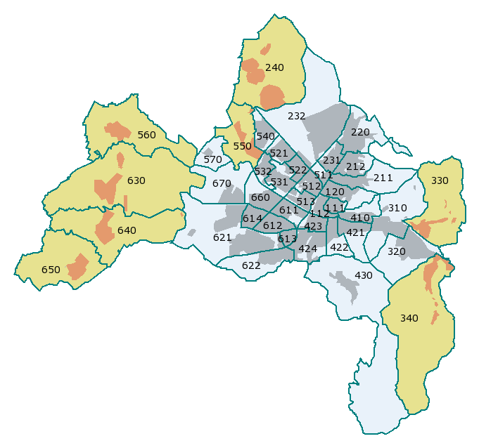
Stadtteile von Freiburg im Breisgau mit ihren amtlichen Nummern
- 111 Altstadt-Mitte
- 112 Altstadt-Ring
- 120 Neuburg
- 211 Herdern-Süd
- 212 Herdern-Nord
- 220 Zähringen
- 231 Brühl-Güterbahnhof
- 232 Brühl-Industriegebiet
- 240 Hochdorf ¹
- 310 Waldsee
- 320 Littenweiler
- 330 Ebnet ¹
- 340 Kappel ¹
- 410 Oberau
- 421 Oberwiehre
- 422 Mittelwiehre
- 423 Unterwiehre-Nord
- 424 Unterwiehre-Süd
- 430 Günterstal
- 511 Stühlinger-Beurbarung
- 512 Stühlinger-Eschholz
- 513 Alt-Stühlinger
- 521 Mooswald-West
- 522 Mooswald-Ost
- 531 Betzenhausen-Bischofslinde
- 532 Alt-Betzenhausen
- 540 Landwasser
- 550 Lehen ¹
- 560 Waltershofen ¹
- 570 Mundenhof
- 611 Haslach-Egerten
- 612 Haslach-Gartenstadt
- 613 Haslach-Schildacker
- 614 Haslach-Haid
- 621 St. Georgen-Nord
- 622 St. Georgen-Süd
- 630 Opfingen ¹
- 640 Tiengen ¹
- 650 Munzingen ¹
- 660 Weingarten
- 670 Rieselfeld
- 680 Vauban - fehlt noch, Karte zeigt Stand von 2006
¹ Orte mit Ortschaftsrat, in der Karte beige gefärbt.
Summary[edit]
Karte selbst erstellt anhand der amtlichen Angaben. Bezirk 680 Vauban (früher Ostteil von 622 und südlichster Teil von 424) ist noch nicht eingetragen.
Licensing[edit]

|
Permission is granted to copy, distribute and/or modify this document under the terms of the GNU Free Documentation License, Version 1.2 or any later version published by the Free Software Foundation; with no Invariant Sections, no Front-Cover Texts, and no Back-Cover Texts. A copy of the license is included in the section entitled GNU Free Documentation License. |
| This file is licensed under the Creative Commons Attribution-Share Alike 3.0 Unported license. | ||
| ||
| This licensing tag was added to this file as part of the GFDL licensing update. |
File history
Click on a date/time to view the file as it appeared at that time.
| Date/Time | Thumbnail | Dimensions | User | Comment | |
|---|---|---|---|---|---|
| current | 14:59, 19 February 2006 | | 681 × 638 (41 KB) | W-j-s (talk | contribs) | == Beschreibung: == Stadtbezirke von Freiburg, differenziert nach Grad der Selbstverwaltung und mit amtlicher Nummer == Autor: == user:w-j-s, Karte selbst erstellt aufgrund amtlicher Angaben (Stadtbezirksgrenzen) |
| 23:43, 18 February 2006 |  | 681 × 638 (18 KB) | W-j-s (talk | contribs) | * Description / Beschreibung: Stadtteile von Freiburg im Breisgau * Karte selbst erstellt |
You cannot overwrite this file.
File usage on Commons
The following page uses this file:
File usage on other wikis
The following other wikis use this file:
- Usage on af.wikipedia.org
- Usage on als.wikipedia.org
- Usage on azb.wikipedia.org
- Usage on de.wikipedia.org
- Usage on de.wikivoyage.org
- Usage on en.wikipedia.org
- Usage on fr.wikipedia.org
- Usage on ja.wikipedia.org
- Usage on nl.wikipedia.org
- Usage on pl.wikipedia.org
- Usage on sl.wikipedia.org