File:Empire of the Kökturks.png
Jump to navigation
Jump to search

Size of this preview: 800 × 499 pixels. Other resolutions: 320 × 200 pixels | 640 × 399 pixels | 1,024 × 638 pixels | 1,280 × 798 pixels | 1,745 × 1,088 pixels.
Original file (1,745 × 1,088 pixels, file size: 2.56 MB, MIME type: image/png)
Captions
Captions
Add a one-line explanation of what this file represents
Summary[edit]
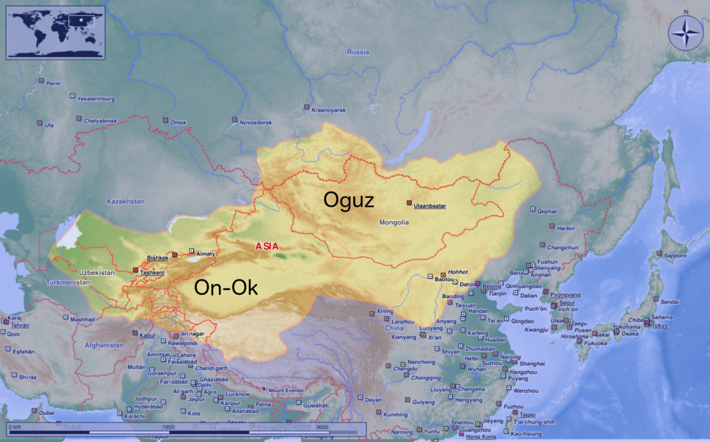
| Description | This map shows the kingdom of Kökturks after the division of the kingdom in 552. The grey area shows the area of On-Ok or the western Kökturks. The white area shows the area of the eastern Kökturk. This area was still in the sixth Century a Chinese protectorate. 745 the Kökturks were part of the Uyghur empire. After 840 Kökturks and the Uyghurs were conquered by the Kyrgyz. The source of this map: "Der große Atlas Weltgeschichte", Orbis Verlag 1990, ISBN 3-572-04755-2, P. 47 & 51 |
| Date | |
| Source | Own work |
| Author | Hardcore-Mike |
Licensing[edit]
I, the copyright holder of this work, hereby publish it under the following license:
This file is licensed under the Creative Commons Attribution 3.0 Unported license.
- You are free:
- to share – to copy, distribute and transmit the work
- to remix – to adapt the work
- Under the following conditions:
- attribution – You must give appropriate credit, provide a link to the license, and indicate if changes were made. You may do so in any reasonable manner, but not in any way that suggests the licensor endorses you or your use.
File history
Click on a date/time to view the file as it appeared at that time.
| Date/Time | Thumbnail | Dimensions | User | Comment | |
|---|---|---|---|---|---|
| current | 10:16, 10 August 2020 | | 1,745 × 1,088 (2.56 MB) | MicBy67 (talk | contribs) | Leichte Überarbeitung der Grenzverläufe, Änderung des westl. Teilreiches in "On-Ok" |
| 00:48, 26 July 2020 |  | 1,745 × 1,088 (2.56 MB) | MicBy67 (talk | contribs) | Überarbeitung | |
| 19:59, 1 November 2012 |  | 1,056 × 850 (1.17 MB) | MicBy67 (talk | contribs) | Map fault repaired | |
| 18:17, 1 November 2012 |  | 1,056 × 850 (1.17 MB) | MicBy67 (talk | contribs) | {{Information |Description=This map shows the kingdom of Kökturks after the division of the kingdom in 552. The grey area shows the area of On-Ok or the western Kökturks. The white area shows the area of the eastern Kökturk. This area was still in t... |
You cannot overwrite this file.
File usage on Commons
There are no pages that use this file.
File usage on other wikis
The following other wikis use this file:
- Usage on ast.wikipedia.org
- Usage on cs.wikipedia.org
- Usage on de.wikipedia.org
- Usage on en.wikipedia.org
- Usage on es.wikipedia.org
- Usage on fr.wikipedia.org
- Usage on mn.wikipedia.org
- Usage on pnb.wikipedia.org
- Usage on sl.wikipedia.org
- Usage on zh.wikipedia.org