File:Donau Einzugsgebiet.png
Jump to navigation
Jump to search
Size of this preview: 800 × 427 pixels. Other resolutions: 320 × 171 pixels | 640 × 342 pixels | 1,024 × 547 pixels | 1,280 × 683 pixels | 2,130 × 1,137 pixels.
Original file (2,130 × 1,137 pixels, file size: 4.04 MB, MIME type: image/png)
Captions
Captions
Danube
Summary[edit]
| Description |
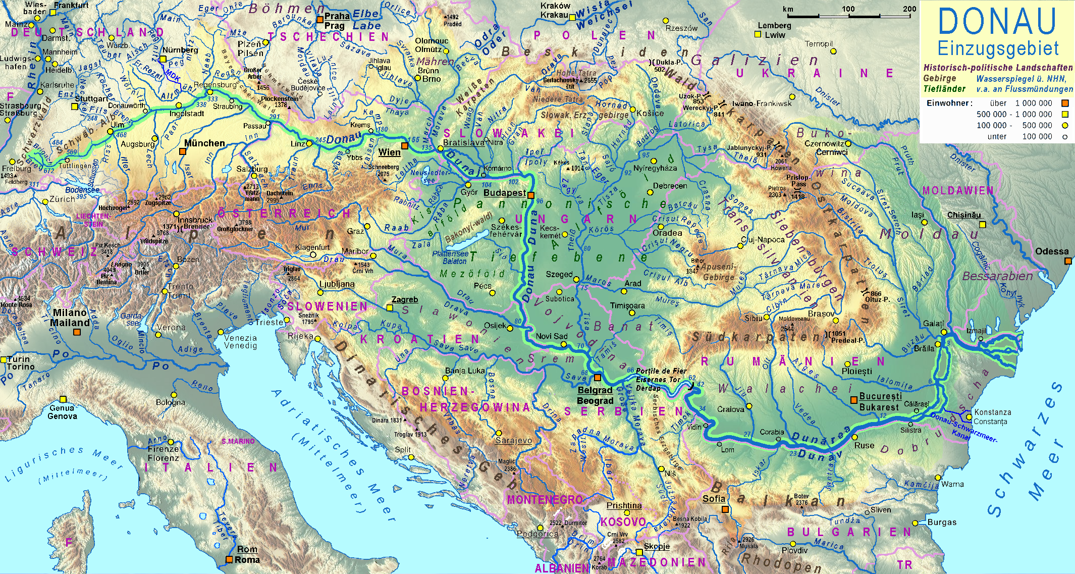
Deutsch: Einzugsgebiet der Donau
English: Basin of the River Danube |
| Date | 2011-10-10, major revision 2016-04-13…15 |
| Source |
|
| Author | TomGonzales, major revision by Ulamm in April 2016 |
| Other versions | file:Tisza Karte.png, file:Aliniamentul Sava-Dunăre.png |

|
This map has been made or improved in the German Kartenwerkstatt (Map Lab). You can propose maps to improve as well.
|
Licensing[edit]
I, the copyright holder of this work, hereby publish it under the following license:
This file is licensed under the Creative Commons Attribution-Share Alike 2.0 Generic license.
- You are free:
- to share – to copy, distribute and transmit the work
- to remix – to adapt the work
- Under the following conditions:
- attribution – You must give appropriate credit, provide a link to the license, and indicate if changes were made. You may do so in any reasonable manner, but not in any way that suggests the licensor endorses you or your use.
- share alike – If you remix, transform, or build upon the material, you must distribute your contributions under the same or compatible license as the original.
File history
Click on a date/time to view the file as it appeared at that time.
| Date/Time | Thumbnail | Dimensions | User | Comment | |
|---|---|---|---|---|---|
| current | 13:59, 6 September 2021 | | 2,130 × 1,137 (4.04 MB) | Claude Zygiel (talk | contribs) | Cosmetic |
| 01:08, 24 June 2018 |  | 2,130 × 1,137 (3.93 MB) | Ulamm (talk | contribs) | + upper course of Dunajec | |
| 13:13, 23 April 2017 |  | 2,130 × 1,137 (3.94 MB) | Ulamm (talk | contribs) | Brenz, Amper, Alz, Moravska Dyje, Reuss | |
| 08:39, 28 December 2016 |  | 2,130 × 1,137 (3.93 MB) | Ulamm (talk | contribs) | + upper Po | |
| 14:00, 22 April 2016 |  | 2,130 × 1,137 (3.93 MB) | Ulamm (talk | contribs) | river name actualized: Kogelnik > Cogâlnic + Kohylnyk | |
| 10:51, 22 April 2016 |  | 2,130 × 1,137 (3.93 MB) | Ulamm (talk | contribs) | sections and passes of the Carpathian Mountains | |
| 14:42, 21 April 2016 |  | 2,130 × 1,137 (3.94 MB) | Ulamm (talk | contribs) | redundance deleted and one more city | |
| 13:59, 21 April 2016 |  | 2,130 × 1,137 (3.94 MB) | Ulamm (talk | contribs) | Dual courses in Romania; major shipping canals | |
| 05:37, 21 April 2016 |  | 2,130 × 1,137 (3.94 MB) | Ulamm (talk | contribs) | eight more rivers, one more town | |
| 01:48, 21 April 2016 |  | 2,130 × 1,137 (3.94 MB) | Ulamm (talk | contribs) | four more rivers, two more cities |
You cannot overwrite this file.
File usage on Commons
The following 2 pages use this file:
- Danube
- File:Verlaufskarte Donau (de).png (file redirect)
.png&redirect=no)
File usage on other wikis
The following other wikis use this file:
- Usage on af.wikipedia.org
- Usage on ast.wikipedia.org
- Usage on de.wikipedia.org
- Usage on diq.wikipedia.org
- Usage on el.wikipedia.org
- Usage on en.wikipedia.org
- Usage on es.wikipedia.org
- Usage on es.wikibooks.org
- Usage on frr.wikipedia.org
- Usage on fr.wikipedia.org
- Usage on he.wikipedia.org
- Usage on hu.wikipedia.org
- Usage on hyw.wikipedia.org
- Usage on it.wikibooks.org
- Usage on nl.wikipedia.org
- Usage on pt.wikipedia.org
- Usage on rm.wikipedia.org
- Usage on ro.wikipedia.org
- Usage on ro.wikivoyage.org
- Usage on rue.wikipedia.org
- Usage on sr.wikipedia.org
- Usage on sv.wikipedia.org
- Usage on tr.wikipedia.org
- Usage on uk.wikipedia.org